
Carrizales, Hatillo, Puerto Rico facts for kids
Quick facts for kids
Carrizales
|
|
|---|---|
|
Barrio
|
|

Sardinera Beach in Carrizales
|
|

Location of Carrizales within the municipality of Hatillo shown in red
|
|

Carrizales, Hatillo, Puerto Rico
Location in Caribbean
|
|
| Commonwealth | |
| Municipality | |
| Area | |
| • Total | 5.09 sq mi (13.2 km2) |
| • Land | 4.4 sq mi (11 km2) |
| • Water | 0.69 sq mi (1.8 km2) |
| Elevation | 108 ft (33 m) |
| Population
(2010)
|
|
| • Total | 8,066 |
| • Density | 1,833.2/sq mi (707.8/km2) |
| Source: 2010 Census | |
| Time zone | UTC−4 (AST) |
| ZIP code |
00659
|
Carrizales is a beautiful coastal area, also known as a barrio, located in the municipality of Hatillo, Puerto Rico. It's a rural spot right by the ocean. In 2010, about 8,066 people lived here.
History of Carrizales
Early Days and Changes
Puerto Rico used to be controlled by Spain. After the Spanish–American War in 1898, Spain gave Puerto Rico to the United States. This happened because of an agreement called the Treaty of Paris of 1898. Puerto Rico then became a territory of the United States.
In 1899, the United States government did a count of all the people in Puerto Rico. This count, called a census, found that 969 people lived in the Carrizales barrio at that time. Over the years, the population of Carrizales has grown quite a lot. For example, by 1950, there were 1,569 people, and by 2010, the population had reached 8,066.
Carrizales Photo Gallery
-
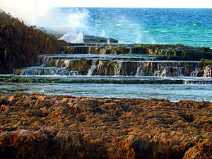
Playa La Sardinera in Carrizales is a great place to visit.
-
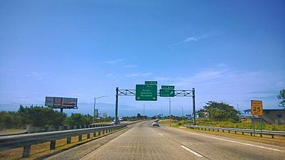
You can see Puerto Rico Highway 22 as it passes through Carrizales.


More to Explore
- List of communities in Puerto Rico
 In Spanish: Carrizales (Hatillo) para niños
