
Carville Historic District facts for kids
Quick facts for kids |
|
|
Carville Historic District
|
|

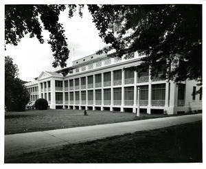
The 1859 Indian Camp Plantation House
|
|

Location in Louisiana

Location in the United States
|
|
| Location | 5445 Point Clair Road, Carville, Louisiana |
|---|---|
| Area | 60 acres (24 ha) |
| Built | 1859, 1939-1941 |
| Architect | Neill P. Thompson; Henry Howard |
| Architectural style | Classical Revival, Italianate |
| NRHP reference No. | 92001529 |
| Added to NRHP | November 18, 1992 |
The Carville Historic District in Carville, Louisiana, is a special place covering about 60 acres. It was added to the National Register of Historic Places on November 18, 1992. This district was once a hospital that helped people with a disease called Hansen's disease, also known as leprosy.
Over the years, it had different names like the National Leprosarium and the Gillis W. Long Hansen's Disease Center. In 1992, the district included 24 important buildings and two structures. Most of these were built between 1939 and 1941. Today, it is home to the National Hansen's Disease Museum, which tells the story of this unique facility.
Contents
History of Carville
From Sugar Farm to Hospital
This land was first a large sugar plantation. The main house, called the Indian Camp Plantation House, was built in 1859 for a sugar farmer named Robert C. Camp.
A Home for Healing
In 1894, this old sugar farm became the Louisiana Leper Home. It was located right by the Mississippi River in Carville. At that time, there wasn't much medicine to treat Hansen's disease. Patients had to stay there and often could not leave.
The "Home" started with just a few patients. It became known as a safe place where people could get care and understanding, not judgment. It offered hope and a comfortable place away from society. Over many years, it grew into a top-notch hospital. It had hundreds of staff and patients, including families with children.
A National Center
In 1921, the U.S. Public Health Service took over the hospital. It became the U.S. Marine Hospital Number 66, which was the main national center for Hansen's disease in the United States. A patient named Stanley Stein started a small newsletter in 1931. This newsletter grew into The STAR, a famous newspaper that is still published today.
In 1981, many U.S. Public Health Service hospitals closed or changed. But the Carville hospital stayed open thanks to Congressman Gillis W. Long. He worked hard to help people with Hansen's disease. He made sure that patients who wanted to stay at Carville could, even though the law no longer required them to be quarantined. In 1986, the hospital was renamed the Gillis W. Long Hansen's Disease (Leprosy) Center to honor him.
The Carville Historic District was created in 1992. In 1996, the National Hansen's Disease Museum opened its doors.
What Happened Next
In 1999, the U.S. Congress decided to move the Hansen's Disease Center to Baton Rouge, Louisiana. The special care and research for Hansen's disease still continue there today.
The federal government gave the Carville site back to the state of Louisiana in 1999. Now, the Louisiana National Guard uses part of the site as a special school for young people. Other military and government groups also use the area. Besides the museum, a few older residents who chose to stay lived on the grounds until 2015.
Today, some of the old buildings need a lot of repair. They are on a list of "Treasures in Trouble" because they are important historical sites.
National Hansen's Disease Museum
The National Hansen’s Disease Museum opened in 1996 at 5445 Point Clair Rd, Carville, Louisiana. It tells the story of the Carville hospital. You can learn about the U.S. Public Health Service and the Daughters of Charity of St. Vincent de Paul who worked as nurses and teachers there.
The museum has exhibits that show what a patient's room looked like in the 1940s. You can also hear stories from patients about their daily lives. The museum shares information about Hansen's disease and how treatments have improved over time.
The museum also keeps old photos and records. These include documents from the Daughters of Charity who worked at the hospital from 1896 to 2005. You can find copies of The STAR newspaper, which started in 1941. There are also old student and employee newsletters.
The property also has a beautiful chapel called the Sacred Heart Chapel. It is still used today and is connected to St. Gabriel Catholic Church.
Historic Buildings
The most important building in the Carville Historic District is the Indian Camp Plantation House. This grand house was built in 1859. It is the only building left from the original sugar plantation. It was designed by a famous architect named Henry Howard. The house has a classic style with tall columns and fancy details.
Many other buildings were added to the site over the years. These include patient living areas, a laundry, staff quarters, and chapels. They were built between 1859 and 1941. Each building tells a part of the long history of this special place.
See also
- List of hospitals in Louisiana
- List of plantations in Louisiana
- National Register of Historic Places listings in Iberville Parish, Louisiana
