Cashlaungar facts for kids
|
An Caisleán Gearr
|
|

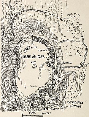
Diagram, Westropp (1913)
|
|
| Alternative name | Cashlaungarr, Cashlaun Gar |
|---|---|
| Location | Parish of Kilnaboy, The Burren |
| Region | Ireland |
| Coordinates | 53°00′48″N 9°04′47″W / 53.013209°N 9.079590°W |
| Type | Ringfort |
| Area | 914 m2 (0.224 acre) |
| History | |
| Material | limestone |
| Site notes | |
| Ownership | Public |
| Public access | Yes |
| Official name | Cashlaungarr |
| Reference no. | 270 |
Cashlaungar, also known as An Caisleán Gearr in Irish, is an ancient stone fort. It's often called a 'ringfort' or 'cashel'. This historic site is a National Monument, meaning it's protected by the government.
You can find Cashlaungar in The Burren, a special region in County Clare, Ireland. It's a cool place to visit if you're interested in old buildings and history!
Where is Cashlaungar?
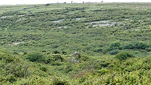
Cashlaungar is right in the middle of The Burren. It's about 2.7 kilometers (1.8 miles) south of a town called Carran. The fort sits on a hill, looking over the road that goes between Kilnaboy and Carran.
It's located in a place called Tullycommon, which is part of the Kilnaboy area. Not far from Cashlaungar, you can also find a bigger ringfort called Cahercommaun and an ancient burial site known as Tullycommon Wedge Tomb.
A Look Back in Time: Cashlaungar's History
The area where Cashlaungar is located, Tullycommon, was mentioned in old records from 1298. It was held by King Torlough O'Brien back then. Imagine armies marching through this land centuries ago! In 1317, an army led by Diarmait O'Brien reportedly passed through on their way to Corcomroe Abbey. They traveled "along the fortress-begirt tracks," meaning there were many forts like Cashlaungar around.
Later, in 1599, troops led by Hugh Roe O'Donnell raided this area during a big attack into Thomond. So, Cashlaungar has seen a lot of action over the centuries!
When archaeologists dug around the fort, they found interesting things. They discovered old trash heaps, called middens. They also found bones from deer and oxen. These finds help us learn about the people who lived here and what they ate.
What Does Cashlaungar Look Like?
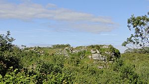
Cashlaungar is a stone fort built on top of a rocky hill with steep sides. It was a strong place to live!
When a historian named Thomas Johnson Westropp visited in the early 1900s, he described the fort's walls. The walls were made of long, carefully shaped stone blocks. In some places, the walls were as high as 4 meters (13 feet) and about 2.7 to 3.0 meters (9–10 feet) thick. That's a very sturdy wall!
The main entrance to the fort was quite high up, about 3 meters (10 feet) above the ground. People probably used a ladder to get in and out. At the bottom of the hill, near the entrance, there were broken pieces of stone. These might have been parts of the gate's roof that fell down.
Inside the fort, it measures about 40 meters (130 feet) from north to south and 23 meters (75 feet) from west to east. Archaeologists also found the remains of four round huts and one 'beehive hut' inside Cashlaungar. These were the homes where people lived long ago!
 | Isaac Myers |
 | D. Hamilton Jackson |
 | A. Philip Randolph |


