
Castle and Lands of Auchruglen facts for kids
Quick facts for kids Auchruglen Castle |
|
|---|---|
| Newmilns, East Ayrshire, Scotland | |

Auchruglen on an 1828 Map
|
|

Auchruglen Castle
|
|
| Coordinates | 55°36′10″N 4°19′28″W / 55.602718°N 4.3244500°W |
| Grid reference | grid reference NS5365436797 |
| Type | Tower |
| Site information | |
| Owner | Private |
| Controlled by | Clan Nesbitt and Clan Campbell |
| Open to the public |
No |
| Condition | Demolished |
| Site history | |
| Built | 16th century |
| Materials | Stone |
Auchruglen Castle was a historic tower located near Newmilns in East Ayrshire, Scotland. It was a type of strong building called a peel tower, used for protection. Over time, it was owned by two powerful Scottish families: the Nesbitts and the Campbells. Today, the castle is gone, but its story remains.
Contents
What was Auchruglen Castle?
Auchruglen Castle was known by many different names, like Achruglen and Auchenruglane. It was a square tower built around 1527. It wasn't a huge fortress, but a safe place for people to go during emergencies. It offered shelter and protection when danger was near.
The castle stood on a steep hill near the River Irvine. Even in 1866, people could still see parts of the old tower. It was a property of the Campbells of Loudoun, but it wasn't their main home.
Above where the castle once stood is a place called Gallow Law Cairn. Long ago, this spot was used for court hearings and punishments. In 1926, local miners built a memorial there. It remembers James Smith, a Covenanter who stood up for freedom in 1684.
Who lived at Auchruglen?
It's not completely clear if Auchruglen was a "Barony," which means a large area of land ruled by a lord. The land was in Kyle, a region where both the Nesbitt and Campbell clans were strong.
We know that James Nesbit owned Auchruglen in 1496. Later, in 1607, Margaret Nisbet married Hugh Campbell of Auchruglen. This shows how the ownership changed between the two clans. In 1553, Mariota Nisbet sold Auchinrugland to Hugh Campbell.
A man named John Campbell from Newmilns was involved with the "Lollards of Kyle." These were some of the first Protestants in Scotland. It's not known if he was connected to Auchruglen Castle.
Later, in 1803, Nicol Brown owned the land of Auchruglen. This shows the property passed through different hands over the centuries.
The Burning of Auchruglen Castle

Local stories say that Auchruglen Castle was destroyed by fire. This happened around 1527. The Kennedys, another powerful clan, are said to have burned it down. They were seeking revenge after the Earl of Cassilis was killed by Hugh Campbell of Loudoun.
However, there are no official records of the castle being burned in criminal files from that time. Many old songs, called ballads, tell stories about castles being burned. One famous ballad, "Adam of Gordon and his Men," talks about the burning of Towie Castle. Sometimes, traveling singers would change these ballads to fit local events.
Some versions of the ballad mention the burning of Loudoun Castle. But some local traditions say that Lady Loudoun and her children were actually at Auchruglen Castle when it was burned. They were hiding there instead of at Loudoun Castle.
An old Scottish record from 1845 says that Auchruglen Tower was indeed burned by the Kennedys. It suggests the fire happened about 350 years before, which would be around the year 1500.
One part of an old ballad even suggests that the attacker was the "Laird of Auchruglen" himself. This shows how different stories and traditions existed about the castle's fate.
Auchruglen Today

On maps from the 1800s, "Auchruglen" is shown as a house, not a castle. It was located near Windyhill and Crosstree Farms. This house was close to the Auchruglin Glen, a small valley with a burn (stream) flowing through it.
By 1895, this property was no longer lived in, but its name was still on maps. It was connected by a small path to Crosstrees Farm. Records show that in the late 1700s, a farmer named Thomas Gebbie lived at Auchruglen and owned a horse. Later, in the mid-1800s, Auchruglen was described as a cottage. It was owned by Thomas Brown.
The Auchruglin Burn starts near Gallow Law and flows past other farms before joining the Irvine Water.
Maps and Records
Old maps help us understand where Auchruglen Castle might have been.
- 1636-52: Gordon's map shows "Achinruglan Castle" on a hill near the River Irvine.
- 1560-1614: Timothy Pont and Joan Blaeu's map clearly shows "Achinrugglan Castle" on the east side of the Auchinrugglan Burn, above Dalloy Farm.
- 1745: Herman Moll's map of Ayrshire shows "Achinrugglan" below Molmont Hill. This is the last clear map showing it as a castle.
- 1775: Andrew Armstrong's map marks an "Auchen" in the area.
- 1832: John Thomson's map shows "Auchruglen" as a dwelling, not a castle, between Windyhill and Crosstree.
- Later maps: Modern maps don't show a castle. However, special Lidar mapping technology suggests there might have been a structure near Mount Pleasant and Crosstrees Farms.
Important Dates for Auchruglen
- 1496: James Nesbit inherited the lands of Auchruglen.
- Around 1527: Local stories say the Kennedys burned Auchruglen Castle.
- 1536 to 1550: The lands of Auchruglen were looked after for two young Nesbit daughters.
- 1553: Mariota Nisbet sold Auchruglen to Hugh Campbell.
- 1607: Margaret Nisbet married Hugh Campbell of Auchruglen.
- 1607: Hew Campbell of Auchruglen was the eldest son of Matthew Campbell and Elizabeth Gordon.
- 1636-52: Gordon's map shows "Achinruglan Castle."
- 1560-1614: Pont and Blaeu's map clearly shows "Achinrugglan Castle."
- 1745: Herman Moll's map is the last to clearly show a castle of that name.
- 1774: Margaret Donald was born in Auchruglen.
- 1775: Andrew Armstrong's map marks an "Auchen."
- 1797-1798: Thomas Gebbie lived at Auchruglen and paid tax for a horse.
- 1803: Nicol Brown became the owner of Auchruglen after John Brown died.
- 1832: John Thomson's map shows "Auchruglen" as a house.
- 1845: A historical account suggests the castle was burned around 1500.
- 1843-1882: The first Ordnance Survey map shows "Auchruglin" as a dwelling.
- 1855-1857: Auchruglen was a cottage occupied by Hugh McInnes.
- 1895: The Auchruglen property was empty but still named on maps.
Images for kids
-
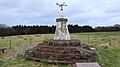
Gallow Law Covenanter Memorial
-
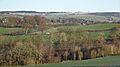
Possible site of Auchruglen Castle


