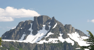
Castlecrag Mountain facts for kids
Quick facts for kids Castlecrag Mountain |
|
|---|---|
 |
|
| Highest point | |
| Elevation | 1,765 m (5,791 ft) |
| Prominence | 123 m (404 ft) |
| Geography | |
| Location | Vancouver Island, British Columbia, Canada |
| Parent range | Vancouver Island Ranges |
| Topo map | NTS 92F/11 |
Castlecrag Mountain is a cool mountain located on Vancouver Island in British Columbia, Canada. It's part of the amazing Vancouver Island Ranges. This mountain stands tall at 1,765 meters (about 5,791 feet) above sea level.
Castlecrag Mountain is found just south of a place called Moat Lake. It's also about 1.6 kilometers (or 1 mile) west of Mount Frink, sharing the same ridge line. Imagine two friends standing close together on a long hill – that's Castlecrag Mountain and Mount Frink!
Exploring Castlecrag Mountain
Many people enjoy hiking and exploring Castlecrag Mountain. It's often climbed as part of a fun adventure called the "Castlecrag - Mt. Frink loop." This means hikers visit both mountains in one trip!
Starting Your Adventure
The journey usually begins at Circlet Lake. To get there, you'd start from Paradise Meadows, which is near the Mount Washington Alpine Resort. It's a popular area for outdoor activities.
Why the Name Castlecrag?
Have you ever wondered how mountains get their names? Castlecrag Mountain got its name because of how it looks, especially from the north side. The mountain has a rugged, rocky appearance that reminded people of a castle.
In 1948, the Geographic Board of the BC Geographic Names Office officially decided on the name "Castlecrag Mountain." They thought "Castle Crag" was a bit too simple, so they added "Mountain" to make it clearer.
 | Madam C. J. Walker |
 | Janet Emerson Bashen |
 | Annie Turnbo Malone |
 | Maggie L. Walker |


