
Castlepoint facts for kids
Quick facts for kids
Castlepoint
Rangiwhakaoma
|
|
|---|---|
|
Town
|
|

Deliverance Cove towards Castlepoint and lighthouse
|
|
| Country | New Zealand |
| Region | Wellington Region |
| Territorial authority | Masterton District |
| Ward |
|
| Electorates |
|
| Area | |
| • Total | 0.81 km2 (0.31 sq mi) |
| Population
(June 2023)
|
|
| • Total | 60 |
| • Density | 74/km2 (192/sq mi) |
Castlepoint is a small beachside village located on the Wairarapa coast in the Wellington Region of New Zealand. It's famous for its tall lighthouse, which stands near the top of a long reef. This reef stretches for about one kilometre.
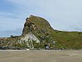
At the southern end of the reef, you'll find an island known as "Seagull Island." It gets its name from the many seagulls that live there. The southern side of Castle Rock is called Christmas Bay. Castlepoint is about an hour's drive from Masterton.
Captain Cook gave Castlepoint its name in 1770. He thought Castle Rock looked like the strong walls of a castle. The Māori name for this area is Rangiwhakaoma, which means 'where the sky runs'. You might spot small sea creatures like dolphins swimming near Castlepoint. Larger whales, like southern right whales and humpback whales, can sometimes be seen from the shore during their migration seasons.
Contents
Exploring Castlepoint's Landmarks
Castle Rock is a very important landmark in Castlepoint. It stands 162 metres high. You can enjoy a walk through woods and over bridges around the rock. This walk takes about 45 minutes.
North of Castlepoint, about 30 minutes away, are the Mataikona Sand Dunes. These are large sand dunes near the mouth of the Matakona River.
Who Lives in Castlepoint?
Castlepoint is a small rural village. It covers about 0.81 square kilometres. In 2018, about 57 people lived here. The population has been growing steadily over the years.
Most people living in Castlepoint are of European descent. A small number are Māori. Many people in Castlepoint say they don't have a religion. Others identify as Christian.
Marae in the Area
The local Whakataki marae is a special meeting place for the Ngāti Kahungunu hapū (sub-tribe) called Te Hika a Pāpāuma ki Wairarapa. A marae is a traditional Māori meeting ground and community area. Sadly, its main meeting house (wharenui) burned down in 1960.
Exciting Annual Horse Races
Since 1872, Castlepoint's beach has hosted a historic annual horse race meeting. Back then, local farm workers would ride their farm horses. They competed for simple prizes like bottles of rum or any spare coins. It's a long-standing tradition in this remote area.
The Famous Castle Point Lighthouse
The Castle Point Lighthouse is a well-known landmark near the village. The Castle Point Lighthouse is managed by Maritime New Zealand. It was built in 1913. It was one of the last lighthouses in New Zealand to have people living and working there.
In the early 1900s, Castle Point was one of the few lighthouses close to a school. This was important for the lighthouse keepers' families. For example, the Creamer family moved there around 1918. Their eldest son, Eric, had to finish five years of school in just three years. This was so he could go to secondary school, as he hadn't had much education at their previous lighthouse homes.
The lighthouse first used oil for its light. In 1954, an electric lamp replaced the oil lamp. This new light was powered by a local diesel generator. Later, in 1961, the lighthouse was connected to the main electricity grid. Many holidaymakers love this lighthouse, and it's sometimes called "The Holiday Light."
The lighthouse was finished on January 12, 1913. It became fully automatic in 1988. Now, it is controlled from a central room in Wellington. Even though it's a popular tourist spot, you cannot go inside the lighthouse.
The lighthouse is built from steel sheets that are riveted together. This is a very unusual way to build a lighthouse. It's the only one built this way in New Zealand.
At sea, the light from Castlepoint can be seen from 22 miles away. Sailors coming from South America used it as a guide when heading towards Wellington Harbour.
You can see a live view of the lighthouse from a camera set up on a nearby outcrop. Just visit castlepointlighthouse.com.
In December 2017, new multi-colour LED lights were added to the lighthouse. These lights shine on the outside of the lighthouse all year round. This cost $35,000. Some people in the Wairarapa region think the lights are too bright and cause unnecessary light pollution.
Images for kids
-
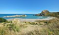
Deliverance Cove and Castle Rock
-
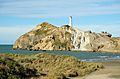
Castlepoint Lighthouse from the beach at Castlepoint
-
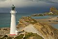
Castlepoint Lighthouse looking towards Castle Rock
-
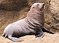
New Zealand fur seal on a rock at Castle point
-
Two surfers and their surfboards in Deliverance Cove in front of Castle Rock


.jpg)
.JPG)
