Caswell, Maine facts for kids
Quick facts for kids
Caswell, Maine
|
|
|---|---|

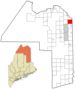
Location of Caswell, Maine
|
|
| Country | United States |
| State | Maine |
| County | Aroostook |
| Village | Caswell Plantation |
| Area | |
| • Total | 41.56 sq mi (107.64 km2) |
| • Land | 41.30 sq mi (106.97 km2) |
| • Water | 0.26 sq mi (0.67 km2) |
| Elevation | 810 ft (247 m) |
| Population
(2020)
|
|
| • Total | 293 |
| • Density | 7/sq mi (2.7/km2) |
| Time zone | UTC-5 (Eastern (EST)) |
| • Summer (DST) | UTC-4 (EDT) |
| ZIP Codes |
04750 (Caswell)
04736 (Caribou) |
| Area code(s) | 207 |
| FIPS code | 23-11335 |
| GNIS feature ID | 0582398 |
Caswell is a small town in Aroostook County, Maine, in the United States. In 2020, about 293 people lived there.
Contents
History of Caswell
The area that is now Caswell was first set up on April 14, 1879. It was called "Pleasant Ridge Plantation" back then. A "plantation" is a type of community in Maine that is not yet a full town.
Later, on July 16, 1986, it officially became an "incorporated" town named Caswell. This means it gained more control over its own local government.
The number of people living in Caswell has gone down a lot since its busiest times. This happened partly because a saw mill in town closed. Also, a nearby military base, Loring Air Force Base, closed in 1994. These closures meant fewer jobs, and many people moved away.
Geography of Caswell
Caswell is located in the state of Maine. It covers a total area of about 41.56 square miles (107.64 square kilometers).
Most of this area, about 41.30 square miles (106.97 square kilometers), is land. The rest, about 0.26 square miles (0.67 square kilometers), is water.
Nearby Towns and Places
Caswell shares its borders with several other towns and places:
- To the north: Hamlin
- To the east: Grand Falls, New Brunswick (in Canada)
- To the southeast: Drummond Parish, New Brunswick (in Canada)
- To the south: Limestone
- To the west: Connor
Population Changes
The number of people living in Caswell has changed over the years. Here is a look at the population from different census years:
| Historical population | |||
|---|---|---|---|
| Census | Pop. | %± | |
| 1890 | 212 | — | |
| 1900 | 368 | 73.6% | |
| 1910 | 529 | 43.8% | |
| 1920 | 558 | 5.5% | |
| 1930 | 642 | 15.1% | |
| 1940 | 650 | 1.2% | |
| 1950 | 687 | 5.7% | |
| 1960 | 853 | 24.2% | |
| 1970 | 693 | −18.8% | |
| 1980 | 586 | −15.4% | |
| 1990 | 408 | −30.4% | |
| 2000 | 326 | −20.1% | |
| 2010 | 306 | −6.1% | |
| 2020 | 293 | −4.2% | |
| U.S. Decennial Census | |||
What the 2010 Census Showed
In 2010, the census counted 306 people living in Caswell. These people lived in 134 different homes. About 91 of these homes were families.
The average age of people in Caswell in 2010 was about 45 years old.
- About 23% of the people were under 18 years old.
- About 25% were between 25 and 44 years old.
- About 26% were between 45 and 64 years old.
- About 25% were 65 years old or older.
The population was split evenly between males and females, with 50% male and 50% female.
Famous Person from Caswell
- Bernard Ayotte was a state representative. This means he was a person who helped make laws for the state of Maine.
See also
 In Spanish: Caswell (Maine) para niños
 | Madam C. J. Walker |
 | Janet Emerson Bashen |
 | Annie Turnbo Malone |
 | Maggie L. Walker |

