
Cato Reef facts for kids

Quick facts for kids Cato Reef |
|
|---|---|

Chart of Cato Reef
|
|

Cato Reef
Location in Queensland
|
|
| Coordinates | 23°15′S 155°32′E / 23.250°S 155.533°E |
| Type | Coral reef |
| Part of | Coral Bank |
| Ocean/sea sources | Coral Sea |
| Max. length | 21 kilometres (13 mi) |
| Max. width | 13 kilometres (8.1 mi) |
| Surface area | 20 square kilometres (7.7 sq mi) |
| Max. depth | 17 metres (56 ft) |
Cato Reef is a special coral reef area in the Coral Sea, located off the coast of Queensland, Australia. It's part of a larger underwater area called Cato Bank.
Contents
What is Cato Reef Like?
Cato Bank is a large underwater area, about 21 kilometers (13 miles) long and 13 kilometers (8 miles) wide. The water here is usually less than 17 meters (56 feet) deep.
Cato Reef itself is smaller, about 3.3 kilometers (2 miles) long and 1.8 kilometers (1.1 miles) wide. It has a shallow lagoon, which is like a small, calm lake inside the reef.
Cato Island: A Small Piece of Land
Inside Cato Reef's lagoon, there's a tiny island called Cato Island. It's a low-lying cay, which is a small, sandy island formed on top of a coral reef. Cato Island is about 650 meters (2,130 feet) long and 300 meters (980 feet) wide. It's only about 6 meters (20 feet) high.
Near the southeast part of Cato Bank, there's a spot called Hutchison Rock. It's just 1 meter (3 feet) below the water's surface.
How Was Cato Reef Formed?
The coral reefs of Cato Reef are built on top of a huge underwater volcano. This volcano was created by eruptions from the Tasmantid Seamount Chain, which is a long line of underwater mountains.
All About Cato Island

Cato Island is a small, oval-shaped island. It's about 375 kilometers (233 miles) east of Gladstone, Queensland and 270 kilometers (168 miles) east-southeast of the southern end of the Great Barrier Reef.
The island is made of coral pieces and sand. It's covered in grass and climbing plants that can grow up to 1 meter (3 feet) tall. On the northeast side of the island, there's an automatic weather station with two radio masts and a silver hut. This station helps scientists gather important weather information.
Reefs almost completely surround Cato Island. There are three narrow paths through the reefs on the northern side where boats can enter. The best way in is through the middle path.
The island sits on the western end of an oval-shaped reef that encloses a lagoon. This lagoon has many coral formations. The ocean waves crash over the reef in all kinds of weather. The reef itself is on Cato Bank, which drops off steeply into deeper water on all sides.
History of Cato Reef
Early Discoveries
Cato Island was first found by Captain John Park on the ship Cato and Lieutenant Robert Fowler on the ship Porpoise on August 17, 1803. The Porpoise later ran aground on a nearby reef called Wreck Reef.
Matthew Flinders, a famous explorer, visited the islands in 1814. He reported that many birds lived on the small islands and laid eggs between August and October. In 1821, a whaling ship named Echo was wrecked on the reef, but its crew was saved.
Cato Reef was a danger to ships traveling between Australia and places like Guangzhou (in China) or India. Because of this, the southern reefs were carefully mapped by Captain H. M. Denham on the ship Herald between 1858 and 1860.
Whalers and Wildlife
In the mid-1800s, more and more whalers visited the area, especially during the off-season in New Zealand. They came looking for humpback whales and sperm whales.
Captain Denham reported in 1863 that the small islands had only a few plants, including a bush about 3 to 4 meters (10 to 13 feet) tall. He also noted that many sea turtles, weighing 60 to 100 kilograms (130 to 220 pounds), visited the islands.
In 1858, Denham described Cato Island as being more solid than other small islands nearby. He said it was covered in coarse grass and other plants. Many shearwaters (also called mutton birds) burrowed into the ground, making it fertile. There were also huge groups of gannets, terns, and noddies, with lots of eggs and chicks. Denham even saw different types of shorebirds like godwits and plovers.
When sailors returned in 1859 with plants and seeds to help any shipwrecked people, Denham reported that the birds were so numerous they formed a cloud above the island. He also mentioned that sailors could collect more than 100 dozen eggs in just three hours!
Guano Mining
In 1862, the British government gave a company called the Anglo-Australian Guano Company the special right to collect guano (bird droppings used as fertilizer) from several islands, including those near Cato Reef. This company was very active on Bird Islet and other islands, but they lost five ships near Bird Islet between 1861 and 1882.
A newspaper report from 1863 mentioned that a message in a bottle was found on Cato Bank. It was from a whaling ship called Prince Edward, which had been whaling in the area.
Shipwrecks Near Cato Reef
Cato Reef has been the site of several shipwrecks over the years, showing how dangerous the area can be for ships.
The Dockenhuden
On August 3, 1853, a German ship called Dockenhuden was sailing between Melbourne and Bombay. It tried to turn near Cato Reef but didn't have enough space and hit the reef, sinking. The crew spent 15 days fixing their small boats before they could leave for Moreton Bay, which they reached safely.
The Thomas King
The Thomas King was a large sailing ship. On April 4, 1852, it left Sydney with a cargo of sugar and spirits, heading for the Philippines and China. However, on April 17, 1852, it crashed into a reef east of Cato Reef and was completely destroyed.
Some of the ship's boats were washed away. One boat set off for the mainland to get help, leaving the remaining crew on the reef. After 14 days, a whaling ship rescued them. The other boat eventually reached Double Island Bay. Sadly, when the people from that boat tried to walk overland to Moreton Bay, most of them were killed by Aboriginal people, except for the captain and one sailor.
When it sank, the Thomas King was carrying a valuable cargo, including gold dust.
Images for kids
-
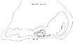
Chart of Cato Reef
See also
 In Spanish: Arrecife Cato para niños
