
Ceann Ear facts for kids
Disambiguation: "Ceann Ear" is a common Scottish placename meaning Eastern Headland
| Gaelic name | Ceann Ear |
|---|---|
| Meaning of name | Eastern Headland |
| OS grid reference | NF640619 |
| Coordinates | 57°31′N 7°37′W / 57.52°N 7.61°W |
| Physical geography | |
| Island group | Monach Islands |
| Area | 203 ha (0.78 sq mi) |
| Area rank | 108 |
| Highest elevation | 17 m (56 ft) |
| Administration | |
| Sovereign state | United Kingdom |
| Country | Scotland |
| Council area | Comhairle nan Eilean Siar |
| Demographics | |
| Population | 0 |
Ceann Ear is the biggest island in the Monach group, also known as Heisgeir. It's located off the coast of North Uist in northwest Scotland. This island is about 203 hectares (500 acres) big. At low tide, you can even walk across sandy paths to nearby islands like Ceann Iar and Sibhinis.
Long ago, people say you could walk all the way from Ceann Ear to Baleshare and then to North Uist. That's about 5 miles (8 km) away! But in the 1500s, a huge tidal wave reportedly washed these sandy paths away. Today, the Monach Islands, including Ceann Ear, are a special nature reserve.
Contents
Life on Ceann Ear: A Look at Human History
Ceann Ear was home to people for at least a thousand years. But eventually, everyone left the island. Like other Monach Islands, people first left because too many animals ate all the plants. This is called overgrazing. Later, people moved back to the island after a time known as the Highland Clearances.
Ancient Religious Sites and Nuns
In the 1200s, a chapel was built on Ceann Ear. This chapel had connections to Iona, a famous island known for its monastery. The monastery was probably at a place called Cladh na Beide in the northeast of the island. The monks living there were in charge of keeping a light burning on nearby Shillay. This light helped warn ships about dangerous rocks.
Ceann Ear was also known as "Heisgeir nan Cailleach." This means "Heisker of the Nuns." It's thought that a nunnery, a home for nuns, might have been built there around the same time. The word cailleach usually means "old woman," but it originally meant a nun.
Unique Homes and Village Life
The islanders on Ceann Ear had a very unusual way of drying their grain. They built their grain drying kilns inside their houses! This was very rare in the Hebrides, the islands off Scotland's west coast. It was more common to see this in Shetland, islands much further north.
Today, you can still see the remains of the old village in the southern part of the island. The old schoolhouse is still kept up. Fishermen use it as a shelter when they are working nearby. The island once had a post office and a school, but there were never any shops.
Exploring Ceann Ear's Natural Environment
Ceann Ear is a low-lying island made mostly of sand. It faces strong coastal erosion, which means the sea and wind slowly wear away the land. The highest point on the island is called Coilleag Mhòr nan Dàmh. It's located at Gortinish, in the northeast.
Weather and Plants
Gale-force winds, which are very strong winds, hit the Monach Isles about 160 days each year. Because of these constant winds, only certain tough plants can grow here. One example is marram grass, which can handle the blowing sand and salty sea spray.
Further inland, away from the coast, you can find more permanent areas of damp grassland. The wettest parts of these grasslands have rushes and moss growing in them.
Water Sources
There are only a few tiny lochs, which are small lakes, on Ceann Ear. All of them are quite salty, and some even dry up during certain times of the year. The remains of the small village of Ceann Ear are found around the biggest loch, called Loch nam Buadh. However, the villagers used to get their fresh drinking water from a few wells nearby.
Images for kids
-
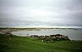
Ruin once used by lobster fishermen at Port Ruadh as a bothy
-
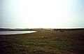
Loch nam Buadh, with the ruins of the village in the distance


See also
 In Spanish: Ceann Ear para niños
