
Central Norwalk facts for kids
Quick facts for kids
Central Norwalk
|
|
|---|---|
| Country | |
| State | |
| County | Fairfield |
| City | Norwalk |
| Time zone | UTC-5:00 (Eastern) |
| • Summer (DST) | UTC-4:00 (Eastern) |
| Area code(s) | 203 |
Central Norwalk, also known as Midtown or Downtown Norwalk, is a busy part of Norwalk, Connecticut. It's located in the middle of the city, just north of the South Norwalk area. Key streets here include Wall Street, West Avenue, and Belden Avenue.
This area is home to many important places. You'll find the state courthouse, the main post office, the Norwalk YMCA, and the Norwalk Library. The River View Mall is also located here.
On the north side of West Avenue, you'll discover Mathews Park. This park is special because it has the Lockwood-Mathews Mansion, a beautiful old house. It also has the Stepping Stones Museum for Children, which is a fun place to learn. You can also find The Center for Contemporary Printmaking here. St. Mary's Roman Catholic Church, with its tall steeple, is another famous building in the neighborhood.
Central Norwalk has been growing a lot recently. New buildings are popping up, and city leaders are even thinking about reopening the Wall Street train station. This would make it easier for people to travel around.
In 2006, local shops started the Main and Wall Street Festival. It began with 15 businesses and grew to 70 businesses by the next year. This festival is a great way for the community to come together and see what's new in the area.
Contents
History of Central Norwalk

This part of Norwalk has a long history. It was once called the Borough of Norwalk, starting in 1836. Later, in 1893, it became the first City of Norwalk. In 1913, Norwalk joined with South Norwalk and other parts of the town to form the city we know today.
Central Norwalk is now known as the First taxing district of the City of Norwalk. This means it's a special area for certain city services and taxes.
A very important historical spot here is the "Norwalk Green Historic District." It was added to the National Register of Historic Places in 1987. This district includes Mill Hill Historic Park, which has the old Norwalk Town House from 1835. It also includes the Norwalk Green, a lovely open space.
New Projects in the Neighborhood
Central Norwalk has seen many plans for new buildings and improvements. These are called redevelopment projects.
River View Plaza Changes
The old River View Plaza area has been transformed. A company called AvalonBay Communities built a large apartment complex there. It now has 312 apartments for people to live in.
West Avenue Plans
In 2007, the city approved plans to update a big area along West Avenue. These plans include building 350 new homes. There will also be over 600,000 square feet of office and retail space. This means more places to live, work, and shop!
Wall Street Updates
The city also approved plans for a 6.3-acre site on Wall Street. A company is building condominiums and townhomes there. This new development is called "Wall Street Place."
Norwalk Town Green
The Norwalk Town Green is a beautiful park in Central Norwalk. It's also known simply as "the Green." For a long time, it was a shared open space. Since 1851, it has been a park managed by Norwalk's First Taxing District.
The Green has a gazebo, which is like a small bandstand. Outdoor concerts are often held there. You can also see a historic cannon. This cannon was made in France in 1881 and was used in a big battle in 1916. France later gave it to Norwalk as a gift. In 2018, a veterans' group donated money to help take care of the cannon. Around its base, there are plaques with the names of local veterans.
The Green is the heart of the Norwalk Green Historic District. This district was added to the National Register of Historic Places in 1987 because of its historical importance.
Irving Freese Park
Irving Freese Park is named after a former mayor, Irving Freese. It was created in the 1960s after a big flood in 1955. The park is located where Main and Wall Streets meet.
From the west side of the park, you can look out over the Norwalk River. There are benches shaded by trees, perfect for relaxing and enjoying the view. The park also has a monument to the Hungarian uprising of 1956. Another plaque remembers Nathan Hale, who started his important spying mission from Norwalk Harbor in 1776.
The park has been improved over the years. In 2007, a power company helped pay for new lights, better pathways, and new railings along the river. These changes made the park even nicer for everyone to enjoy.
Pine Island Cemetery

Pine Island Cemetery is an old burial ground located behind Mathews Park, near the Lockwood-Mathews Mansion Museum. It dates back to 1708 and has about 1,000 graves. The oldest known grave belongs to Elizabeth Bartlet, who died in 1723. She was the wife of one of Norwalk's founders. The cemetery was used for burials until recently, with one as late as 2000.
The Norwalk Historical Commission has been working to get the cemetery listed on the National Register of Historic Places. They want to protect it, especially with new building projects happening nearby.
Emergency Services
The Norwalk Fire Department has two fire stations close to Central Norwalk. Fire Station #1 is on New Canaan Avenue, and Fire Station #2, which is the Fire Headquarters, is on Connecticut Avenue.
In the past, Norwalk's first volunteer fire companies were located in the Wall Street neighborhood. These were Phoenix Hose Co. 1 and Pioneer Hook & Ladder Co. 1. Later, another company, Hope Hose Co. 2, moved into their building.
Images for kids
-
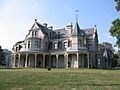
Lockwood-Mathews Mansion Museum, south side
-
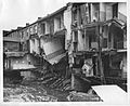
At Main and Wall streets after the October 1955 storm
-
Center for Contemporary Printmaking
-
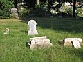
Examples of the many damaged gravestones at Pine Island Cemetery
-
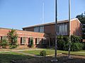
Former police headquarters, Mathews Park
-
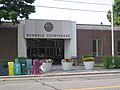
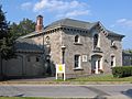
Norwalk Courthouse, Belden Avenue
-
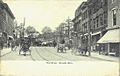
Wall Street, about 1905
-
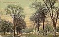
Union Park, about 1913


