
Central Square Historic District (Stoneham, Massachusetts) facts for kids
Quick facts for kids |
|
|
Central Square Historic District
|
|
 |
|

Location in Massachusetts

Location in the United States
|
|
| Location | Roughly bounded by Main, Central, Church, Winter and Common Sts., Stoneham, Massachusetts |
|---|---|
| Architect | Tidd, William; Brown, Charles |
| Architectural style | Mid 19th Century Revival, Classical Revival, Late Victorian |
| MPS | Stoneham MRA |
| NRHP reference No. | 89002277 |
| Added to NRHP | January 17, 1990 |
The Central Square Historic District is a special area in Stoneham, Massachusetts. It's like a time capsule, showing off many old buildings from the 1800s and early 1900s. This area became important for businesses after a big road, the Andover-Medford Turnpike (now Main Street), was built. This historic district was officially recognized and added to the National Register of Historic Places in 1990.
Contents
Discovering Central Square's History
Stoneham is a town located north of Boston. Today, many people who live in Stoneham travel to Boston for work. This is called being a commuter suburb.
Stoneham's Shoemaking Past
In the mid-1800s, Stoneham became a big center for making shoes. At first, people made shoes in small workshops. Over time, these small businesses grew into larger factories. A major road, the Andover Turnpike, and the Boston and Lowell Railroad helped transport shoes and materials.
One important building from this time is the old factory at 426 Main Street. It was built in 1858 by John Hill. This large building was the town's first big factory. It shows the Italianate style of architecture, which was popular back then.
The Heart of Stoneham
The spot where Main Street and Center Street meet became the main business area of Stoneham. Three special buildings built between 1868 and 1890 helped define this area. These buildings, the Dow Block, the Oddfellows Building, and the Chase Block, are all in the Second Empire style. This style often features mansard roofs, which are roofs with four sloping sides.
Important Buildings in the District
The southern part of the historic district includes the old Hill factory building. Right across Main Street is the Stoneham Public Library, built in 1904. This library is a beautiful example of early 20th-century design.
Just north of the main square, you'll find more important town buildings. The Central Firestation, built in 1918, is one of them. The town hall, where local government happens, was built in 1939 on the east side of Center Street.
As you go further north, towards Common Street, you'll see a group of churches. These churches mark the northern edge of the district. They include the First Congregational Church, built in 1840, and the First Unitarian Church, built in 1869. These buildings show different architectural styles from the 1800s.
Images for kids
-
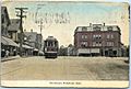
Early-20th-century postcard of the Dow Block

