
Central Square Historic District (Waltham, Massachusetts) facts for kids
Quick facts for kids |
|
|
Central Square Historic District
|
|
 |
|

Location in Massachusetts

Location in the United States
|
|
| Location | Roughly bounded by Church, Carter, Moody, Main and Lexington Sts., Waltham, Massachusetts |
|---|---|
| Area | 6.34 acres (2.57 ha) |
| Architect | Hartwell and Richardson; Et al. |
| Architectural style | Colonial Revival, Late Victorian |
| MPS | Waltham MRA |
| NRHP reference No. | 89001526 |
| Added to NRHP | September 28, 1989 |
The Central Square Historic District is a special area in Waltham, Massachusetts. It's like a time capsule! This district includes the main town common and many old buildings around it. You can find it near Carter, Moody, Main, and Elm Streets. The district has fourteen buildings on Main, Elm, Lexington, and Church Streets. This important area was added to the National Register of Historic Places in 1989.
Even though Waltham was settled a long time ago in the 1600s, it didn't have a clear town center until the 1830s. That's when the Boston Manufacturing Company gave the town land for its central square. The area became even more important when the railroad arrived in the 1840s. A bridge over the Charles River was also built around that time. Waltham officially became a city in 1884.
Contents
Exploring Central Square's History
Waltham's history comes alive in Central Square. Many important buildings are here.
Key Buildings and Their Stories
The City Hall, built between 1924 and 1926, is a beautiful building. It stands on the common at the corner of Main and Elm Streets. It was designed by William Rogers Greely.
The oldest government building in the district is the fire station at 25 Lexington Street. It was built in 1887. This brick building has a unique style called Queen Anne. A local architect named Samuel Patch designed it. Right next to it is the police station, built in 1890. It was designed by the famous architects Hartwell & Richardson.
Across Main Street, you'll see many commercial buildings. These were built mostly between 1880 and 1920. Many of them were designed by Henry W. Hartwell. He also designed the Music Hall building at 15 Elm Street.
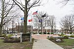
The Heart of the Square: Waltham Common
The common is a big, open space in the middle of Central Square. It's about 2.4 acres in size. Imagine a large rectangle with a smaller piece cut out for City Hall.
Discovering the Common's Features
The common is filled with tall, old trees. It has many paths for walking. You'll also find four important monuments there.
Monuments and Memories
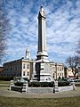
The oldest monument is a tall granite stone with an urn on top. It was designed by George F. Meacham and placed in 1867. This monument remembers the American Civil War.
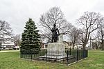
You'll also see a statue of Nathaniel P. Banks. He was born in Waltham and became a Governor of Massachusetts and a General in the Civil War. The statue was designed by Henry Hudson Kitson and placed in 1909.
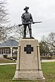
Another statue is called "The Hiker". It's a copy of a memorial to veterans of the Spanish–American War. This statue was designed by Kitson's wife, Theodora. It was placed in the early 1900s.
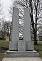
Finally, a memorial celebrating Waltham's 100th birthday was placed in 1984. It reminds everyone of the city's long history.
- Within Waltham Common
-
Nathaniel P. Banks statue
-
Civil War Monument and Town Hall
-
The Hiker
-
Waltham Centennial Memorial
-
Circle of Remembrance


Getting Around Central Square
Central Square is a busy place for transportation. The Waltham commuter rail station is right next door. Many MBTA bus lines also serve the area, connecting it to other parts of the city and beyond.
- 70 Cedarwood, Market Place Drive, or Central Square, Waltham - University Park
- 70A North Waltham - University Park via Watertown Square and Central Square, Cambridge
- 505 Central Square, Waltham - Downtown express via Massachusetts Turnpike
- 553 Roberts - Downtown Boston via Central Square, Waltham, Newtonville, Newton Corner & Turnpike
- 554 Waverly Square - Downtown Boston via Bentley College, Central Square, Waltham, Newtonville, Newton Corner & Turnpike
- 556 Waltham Highlands - Downtown Boston via Central Square, Waltham, Newtonville, Newton Corner & Turnpike
