Cerro Summit facts for kids
Quick facts for kids Cerro Summit |
|
|---|---|

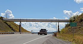
The summit in 2014.
|
|
| Elevation | 8,042 ft (2,451 m) |
| Traversed by | U.S. Route 50 |
| Location | Montrose County, Colorado, United States |
| Coordinates | 38°26′40″N 107°38′33″W / 38.44443°N 107.642498°W |
Cerro Summit is a mountain pass in the beautiful State of Colorado. It is located about 14 miles east of the town of Montrose, Colorado. A mountain pass is like a natural pathway or a lower area between mountains. It makes it easier for people and vehicles to travel across a mountain range.
This pass is important because it divides two different river systems. Water flowing east from the summit goes into the Cimarron River. Water flowing west goes into the Uncompahgre River. Both of these rivers eventually flow into the larger Gunnison River.
Contents
Discovering Cerro Summit
Cerro Summit sits at an elevation of about 8,042 feet (2,451 meters) above sea level. It's a key spot for travel and has an interesting past. Today, it's a place where you can enjoy nature and learn about history.
What is a Mountain Pass?
A mountain pass is a low point in a mountain range. It acts like a natural bridge or gateway. These passes are often used for roads, trails, or even railroads. They help people cross mountains without having to climb over the highest peaks.
A Bit of History
For many years, Cerro Summit has been an important route. Today, U.S. Route 50 travels over the summit. This highway connects many towns and cities across the United States.
Before 1949, a railroad line also crossed Cerro Summit. This was part of the Denver and Rio Grande Western Railroad. Their "Black Canyon line" ran between Gunnison and Montrose.
When it was first built in 1882, this railroad was part of a bigger plan. It was meant to be a "transcontinental line" to Salt Lake City. This means it would connect different parts of the country. Later, other, more direct routes were built.
Railroad Challenges
Even though the highway over Cerro Summit has gentle slopes, the old railroad was much steeper. It had a "ruling gradient" of 4%. This means for every 100 feet forward, the track went up 4 feet.
Because of this steepness, freight trains often needed extra help. They would use a "banker" or "helper" engine. This was an additional locomotive that pushed the train from behind. It helped the train get up the steep hill.
Fun at Cerro Summit
Since 2015, Cerro Summit has been home to the Cerro Summit Recreation Area. This is an "open space" area. It is managed by the City of Montrose.
The recreation area has many hiking trails. It's a great place for outdoor activities. You can explore nature and enjoy the beautiful Colorado scenery.
 | William L. Dawson |
 | W. E. B. Du Bois |
 | Harry Belafonte |

