Cetronia, Pennsylvania facts for kids
Quick facts for kids
Cetronia, Pennsylvania
|
|
|---|---|

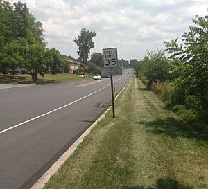
Cetronia in July 2021
|
|

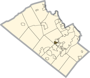
Location of Cetronia in Lehigh County, Pennsylvania
|
|
| Country | |
| State | |
| County | Lehigh |
| Township | South Whitehall |
| Area | |
| • Census-designated place | 0.81 sq mi (2.10 km2) |
| • Land | 0.81 sq mi (2.10 km2) |
| • Water | 0.00 sq mi (0.00 km2) |
| Elevation | 363 ft (111 m) |
| Population
(2020)
|
|
| • Census-designated place | 2,421 |
| • Density | 2,985.20/sq mi (1,152.43/km2) |
| • Metro | 865,310 (US: 68th) |
| Time zone | UTC-5 (EST) |
| • Summer (DST) | UTC-4 (EDT) |
| ZIP Code |
18104
|
| Area code(s) | 610 and 484 |
| FIPS code | 42-12424 |
| GNIS feature ID | 2628811 |
| Primary airport | Lehigh Valley International Airport |
| Major hospital | Lehigh Valley Hospital–Cedar Crest |
| School district | Parkland |
Cetronia is a small community in Pennsylvania, United States. It's known as a census-designated place (CDP). This means it's an area that the government counts as a separate place for population statistics. Cetronia is located in Lehigh County, close to the city of Allentown.
In 2020, about 2,421 people lived in Cetronia. It's part of a larger area called the Lehigh Valley. This bigger area has many towns and cities, and it's home to over 860,000 people.
Contents
Where is Cetronia Located?
Cetronia is found in the middle part of Lehigh County. It's in the southern section of South Whitehall Township.
Nearby Places
- To the north, Cetronia touches Allentown.
- To the southeast, you'll find Dorneyville. This area is also home to Dorney Park & Wildwater Kingdom, a popular amusement park.
Main Roads and Highways
Several important roads run through or near Cetronia:
- Tilghman Street (also known as State Route 1002) goes right through the community.
- Pennsylvania Route 309 forms the western edge of Cetronia.
- Cedar Crest Boulevard is on the far eastern side.
Major highways are also close by:
- Interstate 78 runs southwest of Cetronia.
- Interstate 476 (the Northeast Extension of the Pennsylvania Turnpike) is just west. It separates Cetronia from other small communities like Krocksville and Kuhnsville.
- U.S. Route 22 is about one mile north of Cetronia. It's a major road called the Lehigh Valley Thruway.
Natural Features
Cetronia covers an area of about 2.0 square kilometers (or 0.8 square miles). All of this area is land. A stream called Cedar Creek flows along part of Cetronia's southern border. This creek eventually flows into the Lehigh River, which then joins the Delaware River.
What's in Cetronia?
Even though Cetronia is a smaller community, it has some useful places. The Tilghman Square Shopping Center is nearby. You can also find many restaurants, medical offices, and car dealerships in the general area. However, some of these businesses are just outside the official "census-designated place" boundaries.
Community Services
Cetronia has its own emergency services:
- The Cetronia Ambulance Corps provides ambulance services.
- The volunteer Cetronia Fire Department helps with fires and other emergencies.
These groups serve Cetronia and the areas around it.
How Many People Live Here?
The population of Cetronia has grown over the years. Here's how it has changed:
| Historical population | |||
|---|---|---|---|
| Census | Pop. | %± | |
| 2000 | 1,952 | — | |
| 2010 | 2,115 | 8.4% | |
| 2020 | 2,421 | 14.5% | |
| U.S. Decennial Census | |||
See also
 In Spanish: Cetronia para niños
 | Ernest Everett Just |
 | Mary Jackson |
 | Emmett Chappelle |
 | Marie Maynard Daly |


