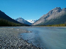
Chaba River (Canada) facts for kids
Quick facts for kids Chaba River |
|
|---|---|

Chaba River and Chaba Icefield
|
|
| Country | Canada |
| Province | Alberta |
| Physical characteristics | |
| Main source | Chaba Icefield 1,597 m (5,240 ft) 52°14′49″N 117°40′52″W / 52.24694°N 117.68111°W |
| River mouth | Athabasca River 1,380 m (4,530 ft) 52°25′05″N 117°39′38″W / 52.41806°N 117.66056°W |
The Chaba River is a cool, short river located in western Alberta, Canada. It flows from the amazing Canadian Rockies mountains and eventually joins up with the larger Athabasca River.
Contents
Where Does the Chaba River Get Its Water?
The Chaba River is a really important stream that feeds into the Athabasca River. Most of its water comes from melting ice and snow. This meltwater flows from the Chaba Icefield.
What Is the Chaba Icefield?
The Chaba Icefield is a large area of ice and snow. It includes tall mountains like Chaba Peak. Other peaks, Listening Peak and Sundial Peak, also contribute water. Even a small glacier on Mount Quincy adds to the river's flow.
How Did the Chaba River Get Its Name?
The river was named by a geologist named A. P. Coleman. He was born in Eastern Canada in 1852. Coleman explored the area and noticed something special.
What Did A. P. Coleman Observe?
Coleman saw "endless beaver dams and trees" along the river. Beavers are amazing builders! Because of all the beavers, he named the river "Chaba." This word means "beavers" in the language of the Stoney Indigenous people.
 | Selma Burke |
 | Pauline Powell Burns |
 | Frederick J. Brown |
 | Robert Blackburn |

