Chabinoche River facts for kids
Quick facts for kids Chibinoche |
|
|---|---|

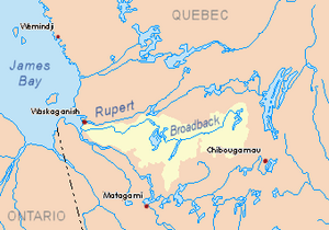
Watershed of Broadback River
|
|
| Country | Canada |
| Province | Quebec |
| Region | Eeyou Istchee Baie-James (municipality) |
| Physical characteristics | |
| Main source | Chabinoche Lake Eeyou Istchee Baie-James (municipality), Nord-du-Québec, Quebec 276 m (906 ft) 50°30′19″N 77°06′56″W / 50.50528°N 77.11556°W |
| River mouth | Evans Lake, Broadback River Eeyou Istchee Baie-James (municipality), Nord-du-Québec, Quebec 241 m (791 ft) 50°41′38″N 77°09′20″W / 50.69389°N 77.15556°W |
| Length | 33.1 km (20.6 mi) |
The Chabinoche River is a river located in the Nord-du-Québec region of Quebec, Canada. It flows into Evans Lake, which is part of the larger Broadback River system. The river is found in the Eeyou Istchee Baie-James (municipality) area.
A forest road provides access to the northern part of this river's area. The river's surface is usually frozen from early November until mid-May. However, it's generally safe to travel on the ice from mid-November to mid-April.
Contents
Where the Chabinoche River Flows
The Chabinoche River is surrounded by other important water bodies. Knowing these helps us understand its place in the region.
Nearby Rivers and Lakes
- To the north, you'll find Evans Lake and the Broadback River.
- To the east are the Salamandre River, Salamandre Lake, and Quenonisca Lake.
- To the south, there's the Muskiki River and Soscumica Lake.
- To the west, you'll see the Iskaskunikaw River, Pauschikushish Ewiwach River, and Kakaskutatakuch River.
The River's Journey
The Chabinoche River starts at the mouth of Lac Chabinoche. This lake is 5.2 kilometres (3.2 mi) long and sits at an altitude of 276 metres (906 ft).
- Lac Chabinoche is about 31.1 kilometres (19.3 mi) north of Soscumica Lake.
- It's also about 92.6 kilometres (57.5 mi) north of the town of Matagami.
From Lac Chabinoche, the Chabinoche River flows for a total of 33.1 kilometres (20.6 mi).
From Source to Lake Ouagama
- For the first 23.4 kilometres (14.5 mi), the river flows generally north. It makes a big curve towards the east. This part of the river leads to the south shore of Lake Ouagama.
Through Lake Ouagama
- Next, the river crosses Lake Ouagama for 5.7 kilometres (3.5 mi). Lake Ouagama is 6.3 kilometres (3.9 mi) long and is at an altitude of 259 metres (850 ft).
Final Stretch to Evans Lake
- The last 4.0 kilometres (2.5 mi) of the river flows north. It then reaches its end, flowing into the Southwest Bay of Evans Lake. The Broadback River also flows through Evans Lake.
Where the River Ends
The Chabinoche River's end point is located:
- About 12.5 kilometres (7.8 mi) east of Dana Lake.
- Around 45 kilometres (28 mi) north of Soscumica Lake.
- About 42.8 kilometres (26.6 mi) south of where Evans Lake flows out.
- Roughly 110 kilometres (68 mi) north of downtown Matagami.
What's in a Name?
The name "Chabinoche River" was officially recognized on December 5, 1968. This happened when the Commission de toponymie du Quebec (Quebec's Place Names Commission) was first created. This commission is responsible for naming places in Quebec.
 | Lonnie Johnson |
 | Granville Woods |
 | Lewis Howard Latimer |
 | James West |

