Dana Lake facts for kids
Quick facts for kids Dana Lake |
|
|---|---|

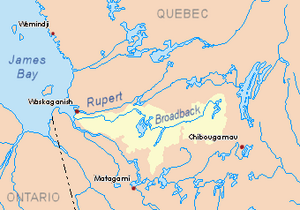
Broadback River basin in yellow
|
|
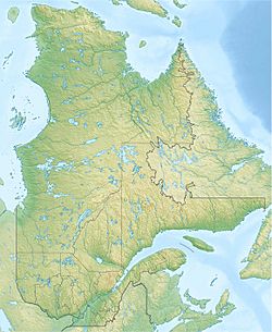
| Location | Baie-James |
| Coordinates | 50°53′03″N 77°20′15″W / 50.88417°N 77.33750°W |
| Type | Natural |
| Primary inflows | Discharge of Du Tast Lake, Utamikaneu River, Kapisaukanew creek, Pauschikushish Ewiwach River, Enistustikweyach River, Upaunan River. |
| Primary outflows | Evans Lake, Broadback River |
| Basin countries | Canada |
| Max. length | 37.5 kilometres (23.3 mi) |
| Max. width | 7.5 kilometres (4.7 mi) |
| Surface elevation | 241 metres (791 ft) |
Lake Dana is a large freshwater lake in the Eeyou Istchee Baie-James area of northern Quebec, Canada. It's an important part of the region's natural environment.
You can get to the lake by a forest road. This road goes north from Matagami and passes about 13.4 kilometers (8.3 miles) west of the lake. The lake's surface usually freezes over from early November until mid-May. It's generally safe to travel on the ice from mid-November to mid-April.
Contents
Exploring Dana Lake
Lake Dana is quite long, stretching about 37.5 kilometers (23.3 miles). It has two main sections. At its widest point, in the southern part, it measures about 7.5 kilometers (4.7 miles) across. The lake sits at an elevation of 241 meters (791 feet) above sea level.
Two Main Parts of the Lake
A land feature called Kapunamisi Point extends northeast for about 6.4 kilometers (4 miles). This point helps divide Lake Dana into two distinct parts.
The northern part of the lake is shaped like a crescent moon. It's quite long for boating, with a navigable length of about 60 kilometers (37 miles). This includes a bay where the Utamikaneu River flows in. The northern part receives water from the Utamikaneu River on its west side. It also gets water from Du Tast Lake to the north. This section of the lake features interesting areas like Wapushunikw Peninsula, Kaupakameyach Point, and Chipikamikw Point.
The southern part of the lake is about 12.7 kilometers (7.9 miles) long. Several rivers flow into this section. These include the Pauschikushish Ewiwach River, the Enistustikweyach River, and the Upaunan River. The last two rivers empty into Kapichiwashahach Bay. You'll find two hills near the southern part: Mitapeschikaw hill to the west and Epaschipich hill to the east.
Connecting the Lake Sections
Lake Dana has many bays and peninsulas. The two main parts of the lake are connected by a narrow strait. This strait is about 3.8 kilometers (2.4 miles) long. Its width changes, ranging from 0.3 kilometers (0.19 miles) to 0.5 kilometers (0.31 miles). The land around Lake Dana has many marshy areas.
Where the Water Goes
The water from Dana Lake flows directly into Evans Lake. This connection happens through a short strait known as Pastukamau Pass. This pass links Dana Lake to the West Bay of Evans Lake.
The exit point of Dana Lake is in a bay to the northwest. From this point:
- It's about 26.0 kilometers (16.2 miles) southwest of where Evans Lake empties.
- It's about 9.7 kilometers (6 miles) southwest of Kirk Island, which is in Evans Lake.
- It's about 126.5 kilometers (78.6 miles) east of where the Broadback River meets James Bay.
- It's about 133.6 kilometers (83 miles) north of downtown Matagami.
Nearby Water Systems
The main rivers and lakes near Dana Lake include:
- North side: Broadback River, Rupert River
- East side: Evans Lake, Broadback River
- South side: Muskiki River, Chabinoche river, Enistustikweyach river
- West side: Rodayer Lake, Desorsons Lake, Nottaway River
Naming the Lake
The name "Lac Dana" was officially recognized on December 5, 1968. This was done by the Commission de toponymie du Québec, which is the organization responsible for naming places in Quebec.
 | DeHart Hubbard |
 | Wilma Rudolph |
 | Jesse Owens |
 | Jackie Joyner-Kersee |
 | Major Taylor |


