Utamikaneu River facts for kids
Quick facts for kids Utamikaneu |
|
|---|---|

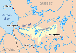
Watershed of Broadback River
|
|
| Country | Canada |
| Province | Quebec |
| Region | Eeyou Istchee Baie-James (municipality) |
| Physical characteristics | |
| Main source | Utamikaneu Lake Eeyou Istchee Baie-James (municipality), Nord-du-Québec, Quebec 262 m (860 ft) 50°52′17″N 77°34′56″W / 50.87139°N 77.58222°W |
| River mouth | Broadback River Eeyou Istchee Baie-James (municipality), Nord-du-Québec, Quebec 241 m (791 ft) 50°59′19″N 76°34′50″W / 50.98861°N 76.58056°W |
| Length | 24.0 km (14.9 mi) |
The Utamikaneu River is a river in Quebec, Canada. It flows into Dana Lake (Eeyou Istchee Baie-James). This lake is part of the larger Broadback River system. The river is located in the Eeyou Istchee Baie-James (municipality) area. This region is in Nord-du-Québec, a northern part of Quebec.
A road from Matagami passes close to the river's source. The river usually freezes over from early November to mid-May. It is generally safe to travel on the ice from mid-November to mid-April.
Contents
Exploring the Utamikaneu River's Path
The Utamikaneu River is surrounded by other important waterways. These are called hydrographic slopes. They show which way the water flows.
Rivers and Lakes Nearby
- On the north side, you'll find the Kauskatitineu River, Broadback River, and Ouasouagami River.
- To the east are Dana Lake (Eeyou Istchee Baie-James), Evans Lake, and the Broadback River.
- South of the Utamikaneu are the Matawawaskweyau River, Pauschikushish Ewiwach River, and Kapitastikweyack Creek.
- To the west, there are Dodayer Lake, Desorsons Lake, Chaboullié Lake, Wemistikushiiuch Kawichitwaw Creek, and the Nottaway River.
Where the Utamikaneu River Starts
The Utamikaneu River begins at Utamikaneu Lake. This lake is about 262 metres (860 ft) above sea level.
The source of the river is located:
- About 10.7 kilometres (6.6 mi) west of where the Utamikaneu River meets Dana Lake.
- About 31.2 kilometres (19.4 mi) southwest of where Dana Lake meets Evans Lake.
- About 53.8 kilometres (33.4 mi) southwest of where Evans Lake joins the Broadback River.
- About 60.0 kilometres (37.3 mi) northwest of Lake Soscumica.
- About 103 kilometres (64 mi) east of the mouth of the Broadback River.
- About 123.3 kilometres (76.6 mi) north of the town of Matagami.
How the River Flows
The Utamikaneu River flows for about 24.0 kilometres (14.9 mi). It follows these main directions:
- It flows southeast for about 10.2 kilometres (6.3 mi) until it meets a small creek.
- Then, it turns northeast for about 9.2 kilometres (5.7 mi) to meet another creek.
- Finally, it flows east for about 4.6 kilometres (2.9 mi) until it reaches its mouth.
Where the River Ends
The Utamikaneu River flows into a bay on the west side of Dana Lake (Eeyou Istchee Baie-James). Dana Lake then flows into the west side of Evans Lake. The Broadback River flows through Evans Lake towards the north.
The mouth of the Utamikaneu River is located:
- About 14.1 kilometres (8.8 mi) southwest of the mouth of Dana Lake (Eeyou Istchee Baie-James).
- About 38.3 kilometres (23.8 mi) southwest of the mouth of Evans Lake.
- About 61 kilometres (38 mi) north of Lake Soscumica.
- About 111.7 kilometres (69.4 mi) east of the mouth of the Broadback River.
- About 123.3 kilometres (76.6 mi) north of downtown Matagami.
What's in a Name? The Utamikaneu River's Meaning
The name "Utamikaneu River" comes from the Cree language. In Cree, this name means "the river of the cheek."
The official name "Utamikaneu River" was formally recognized on October 5, 1982. This was done by the Commission de toponymie du Québec, which is the official body for naming places in Quebec.
 | Kyle Baker |
 | Joseph Yoakum |
 | Laura Wheeler Waring |
 | Henry Ossawa Tanner |

