
Chain of Rocks Bridge facts for kids
Quick facts for kids Chain of Rocks Bridge |
|
|---|---|
 |
|
| Coordinates | 38°45′38″N 90°10′35″W / 38.76056°N 90.17639°W |
| Carries | Pedestrians and bicycles (1998–present) |
| Crosses | Mississippi River |
| Locale | St. Louis, Missouri / Madison, Illinois |
| Maintained by | Trailnet |
| Characteristics | |
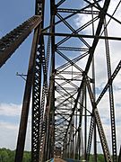
| Design | Cantilever through-truss |
| Total length | 5,353 feet (1,632 m) |
| Width | 24 feet (7 m) |
| Longest span | 700 feet (213 m) |
| History | |
| Opened | 1929 |
| Closed | 1970 (vehicle traffic) |
|
Chain of Rocks Bridge
|
|
| Lua error in Module:Location_map at line 420: attempt to index field 'wikibase' (a nil value). | |
| Location | West Chain of Rocks Rd., Madison, Illinois |
| Area | 12.6 acres (5.10 ha) |
| Built | 1929 |
| Architect | Brown, Baxter L.; et al. |
| Architectural style | Warren Truss |
| MPS | Route 66 through Illinois MPS |
| NRHP reference No. | 06001091 |
| Added to NRHP | December 01, 2006 |
The Chain of Rocks Bridge is an old bridge that crosses the Mississippi River. It's located on the northern edge of St. Louis, Missouri. One end of the bridge is in Madison, Illinois, on Chouteau Island. The other end is on the Missouri side. This bridge is famous for a unique feature: it has a 22-degree bend right in the middle!
This bridge was once a busy road for cars. It was even part of the famous U.S. Route 66. But now, it's a special path just for people who want to walk or ride bikes. A newer bridge, called the New Chain of Rocks Bridge, handles all the car traffic nearby. The old road leading to the bridge is now called Chain of Rocks Road. You can park there and start your walk or bike ride. In 2006, the bridge was added to the National Register of Historic Places. This means it's an important historical landmark.
Contents
What's in a Name?
The bridge gets its name from a dangerous part of the Mississippi River. This area was called the "Chain of Rocks." It was a series of rocky rapids that made it very hard for boats to pass safely.
In the 1960s, a special dam was built. This dam covered most of the rocky area. Now, you can only see the Chain of Rocks when the water level is extremely low. Before this dam, the Chain of Rocks was the only thing stopping boats from having a clear path on the Mississippi River. This path stretched all the way from St. Paul, Minnesota, to New Orleans.
The Chain of Rocks Reach
This tricky part of the river was about 17 miles (27 km) long. It started just north of St. Louis. It was a series of rock ledges that were very difficult and risky for boats to navigate.
In the late 1940s and early 1950s, the U.S. Army Corps of Engineers built a new canal. This canal was about 8.4 miles (13.5 km) long. It helped boats avoid the dangerous Chain of Rocks area. They also built a dam, called Dam No. 27, and a lock, called Locks No. 27. These structures helped keep the water deep enough for boats.
Bridge History
The area around the bridge was chosen for the St. Louis water system in 1865. Construction started in 1887, and the water plant opened in 1894. A filter plant was added in 1915. At that time, it was the largest filter plant in the world!
Building the Bridge
The Chain of Rocks Bridge was built in 1929. It cost $3 million to build. It started as a toll bridge, meaning people had to pay to cross it. Later, it was given to the city of Madison, Illinois, which still owns it today. Engineers thought that ten workers might die during construction. However, only one worker was killed, which was a remarkable achievement for such a large project back then.
Route 66 and Beyond
In the late 1930s, the bridge became part of Bypass US 66. This route helped drivers avoid the busy downtown area of St. Louis. On August 2, 1966, the tolls were removed. This ended a long disagreement about tolls with the state of Missouri.
In 1966, a new bridge was built right next to the Chain of Rocks Bridge. This new bridge, the New Chain of Rocks Bridge, carries I-270 traffic. Because of the new bridge, the old Chain of Rocks Bridge was closed to cars on February 25, 1970.
A New Purpose
For almost 30 years, no one knew what would happen to the bridge. Many thought it would be torn down. But tearing it down would have been very expensive. So, it stayed until a new use was found for it.
In 1998, a local group called Trailnet leased the bridge. They wanted to turn it into a path for walking and biking. About $4.5 million was spent to fix up the bridge for this new purpose.
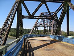
Today, if you visit the bridge, you'll see signs for "HISTORIC ROUTE 66." From the bridge, you can even see the famous Gateway Arch downriver. You can also spot two old water intake buildings for the St. Louis Waterworks. One looks like an old castle, and the other looks like ancient Roman ruins.
Gallery
-
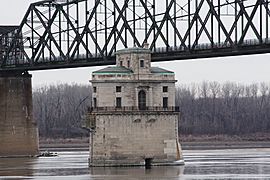
Water intake with one span of the Chain of Rocks Bridge
-
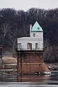
Water intake near Chain of Rocks Bridge
-
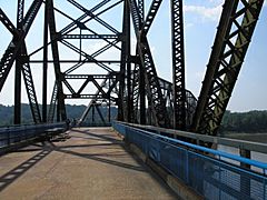
View on the bridge
-
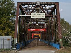
Illinois entrance to bridge
-
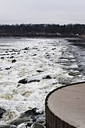
Low-water River Dam #27
-
Just inside Illinois entrance to bridge
-
Close-up photo of 22-degree bend


