
Chaiyaphum province facts for kids
Quick facts for kids
Chaiyaphum
ชัยภูมิ
|
|||
|---|---|---|---|

Pa Hin Ngam National Park
|
|||
|
|||
| Motto(s):
"ชัยภูมิ เมืองผู้กล้า พญาแล" ("Chaiyaphum, Brave city and Phaya Lae")
|
|||

Map of Thailand highlighting Chaiyaphum province
|
|||
| Country | Thailand | ||
| Capital | Chaiyaphum | ||
| Area | |||
| • Total | 12,698 km2 (4,903 sq mi) | ||
| Area rank | Ranked 8th | ||
| Population | |||
| • Total | 1,137,357 | ||
| • Rank | Ranked 19th | ||
| • Density | 91/km2 (240/sq mi) | ||
| • Density rank | Ranked 51st | ||
| Human Achievement Index | |||
| • HAI (2017) | 0.5744 "somewhat low" Ranked 48th |
||
| Time zone | UTC+7 (ICT) | ||
| Postal code |
36xxx
|
||
| Calling code | 044 | ||
| ISO 3166 code | TH-36 | ||


Chaiyaphum (Thai: ชัยภูมิ) is one of Thailand's 76 provinces. It is located in the central northeastern part of Thailand, an area also known as Isan. The provinces that border Chaiyaphum are Khon Kaen to the north, Nakhon Ratchasima to the east, Lopburi to the south, and Phetchabun to the west.
Contents
What Does "Chaiyaphum" Mean?
The name Chaiyaphum has a special meaning. The word chaiya comes from the ancient Sanskrit word jaya, which means 'victory'. The word phum comes from the Sanskrit word bhumi, meaning 'earth' or 'land'. So, the name of the province literally means 'land of victory'. It's like saying "Victory Land"!
Exploring Chaiyaphum's Geography

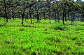
Chaiyaphum province is split by the Phetchabun mountain range. The highest point in the province is 1,222 meters tall. The eastern part of the province is a flat area called the Khorat Plateau. About 31.4 percent of the province is covered by forests, which is a large area of 3,982 km2 (1,537 sq mi).
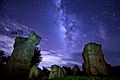
Amazing National Parks
Chaiyaphum is home to several beautiful national parks, which are protected areas of nature.
- Tat Ton National Park is in the northwest. It has lovely waterfalls and dry forests.
- Sai Thong National Park in the west is famous for its Sai Thong waterfall. You can also see fields of the beautiful Siam tulip flower there.
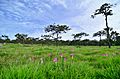
- Pa Hin Ngam National Park in the southwest also has fields of Siam tulips. Its name means 'beautiful rock forest' because of the unique, strangely shaped rock formations you can find there.
- Phu Laen Kha National Park covers 200 km2 (77 sq mi) of forested hills northwest of Chaiyaphum city.
There are six national parks in total:
- Nam Nao National Park, 966 km2 (373 sq mi)
- Sai Thong National Park, 319 km2 (123 sq mi)
- Tat Ton National Park, 217 km2 (84 sq mi)
- Nam Phong National Park, 197 km2 (76 sq mi)
- Phu Laenkha National Park, 200 km2 (77 sq mi)
- Pa Hin Ngam National Park, 100 km2 (39 sq mi)
Wildlife Sanctuaries
Chaiyaphum also has three wildlife sanctuaries, which are special places to protect animals and their homes:
- Phu Khiao Wildlife Sanctuary, 1,560 km2 (600 sq mi)
- Tabo–Huai Yai Wildlife Sanctuary, 654 km2 (253 sq mi)
- Pha Phueng Wildlife Sanctuary, 189 km2 (73 sq mi)
A Look at Chaiyaphum's History
The history of Chaiyaphum city goes back a long time, to the 12th century. Back then, during the Khmer Empire, it was a small town along an important travel route.
In 1817, people from Laos came to settle in the area. They were led by a man named Nai Lae. He was an official working for King Anouvong of Vientiane, which was a state that paid tribute to the Thai king. Nai Lae and his people first settled in another area, but soon moved to what is now Chaiyaphum city.
In 1826, King Anouvong decided to fight against the Thai King Rama III to gain full independence. Nai Lae, who had become a high-ranking official called a chao praya by the Thai king, chose to support the Thai army. He bravely defended his city against Anouvong's army but was sadly killed. A few weeks later, Anouvong was defeated by the Thai forces.
King Rama III remembered Nai Lae's loyalty. He honored him with the title Phraya Phakdi Chumpon. Today, Phraya Phakdi Chumpon is still seen as a local hero in Chaiyaphum. His statue is a symbol of the province, reminding everyone of his courage and loyalty.
The People of Chaiyaphum
Most people living in Chaiyaphum province are ethnically Lao. This means their families originally came from Laos. The main language spoken by most people here is the Lao language.
Chaiyaphum's Economy

The main crops grown in Chaiyaphum are rice, tapioca (used to make things like tapioca pearls), sugar cane, and taro root. These crops are very important for the province's economy.
The Chulabhorn Dam is a major source of water for farming. It helps to irrigate the fields. Because of a serious drought in 2019, there are plans to build three more dams in Chaiyaphum. These new dams would help store more water for irrigation, which is very important for the farmers in the area.
Health Services
The main hospital in Chaiyaphum province is Chaiyaphum Hospital. It is run by the Ministry of Public Health.
Symbols of Chaiyaphum
Every province has symbols that represent it.
- The provincial seal shows a triangular flag. This flag is a symbol of victory in war.
- The provincial tree is the Siamese senna (Cassia siamea).
- The provincial flower is the beautiful Siam Tulip (Curcuma alismatifolia).
The provincial slogan is: "เมืองโบราณ บ้านนักสู้ ภูเสียดฟ้า ป่าช้างหลาย ทุ่งไพรรก น้ำตกใส ผ้าไหมดี สตรีงาม แดนธรรมแดนทอง". This translates to: 'Enchanted city, home to heroes, mountain peaks, elephant forests, waterfalls, beautiful silk, lovely ladies, conscientious Buddhists'. It describes many wonderful things about Chaiyaphum!
How Chaiyaphum is Governed
Provincial Government
Chaiyaphum province is divided into 16 main areas called districts (amphoes). These districts are then further divided into 124 subdistricts (tambons) and 1,393 villages (mubans).
|

Local Government
As of late 2019, Chaiyaphum has one main Provincial Administration Organisation. It also has 36 municipal areas. The city of Chaiyaphum itself has "town" status (thesaban mueang). There are also 35 smaller subdistrict municipalities (thesaban tambon). The areas that are not municipalities are managed by 106 Subdistrict Administrative Organisations (SAOs).
Images for kids
-

Sai Thong National Park
-

Pha Ham Hot, Sai Thong National Park
-

Pha Ham Hot, Sai Thong National Park
-
Pathumma (Curcuma alismatifolia), Sai Thong National Park
-

Phu Laen Kha National Park
-
Phu Laen Kha National Park
-

Phu Laen Kha National Park
-
Pathumma (Curcuma alismatifolia), Pa Hin Ngam National Park


See also
 In Spanish: Provincia de Chaiyaphum para niños
- Khit cloth
