Chapo Lake facts for kids
Quick facts for kids Chapo Lake |
|
|---|---|
 |
|
| Coordinates | 41°27′S 72°30′W / 41.450°S 72.500°W |
| Basin countries | Chile |
| Max. length | 17 km (11 mi) |
| Max. width | 5 km (3.1 mi) |
| Surface area | 45.3 km2 (17.5 sq mi) |
| Average depth | 183.1 m (601 ft) |
| Max. depth | 298 m (978 ft) |
| Water volume | 8.296 km3 (1.990 cu mi) |
| Surface elevation | 234 m (768 ft) |
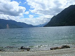
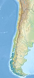
Chapo Lake (which is Lago Chapo in Spanish) is a beautiful lake found in Chile. It is located in the Los Lagos Region, a part of southern Chile.
This lake is an important natural feature. It sits close to some interesting landmarks. For example, it is just southeast of the Calbuco volcano. It is also south of the Llanquihue National Reserve. Right to the south of the lake, you can find the Alerce Andino National Park.
Contents
Where is Chapo Lake Located?
Chapo Lake is in the area called Puerto Montt. This is in the Llanquihue province. It is part of the Los Lagos Region in Chile.
Getting to Chapo Lake
The lake is about 115 kilometers (71 miles) southeast of Puerto Varas. It is also 43 kilometers (27 miles) northeast of Puerto Montt city. If you are in Correntoso, the lake is only 8 kilometers (5 miles) to the east.
How is Chapo Lake Used?
Chapo Lake is more than just a pretty place. It plays a role in providing power. The water from the lake is used to help create hydroelectric power. This means it helps make electricity using the force of water.
Lake's Water Flow
The water that flows out of Chapo Lake goes into the Reloncaví Estuary. An estuary is where a river meets the sea. So, the lake's water eventually reaches the ocean.
See also
 In Spanish: Lago Chapo para niños
 | Jessica Watkins |
 | Robert Henry Lawrence Jr. |
 | Mae Jemison |
 | Sian Proctor |
 | Guion Bluford |


