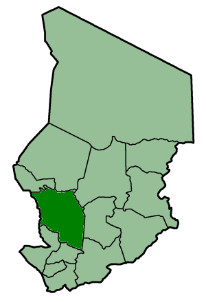
Chari-Baguirmi facts for kids
Chari-Baguirmi was an important administrative area, or prefecture, in the country of Chad. It was one of 14 prefectures that existed in Chad for many years. Think of a prefecture like a large county or region within a country. Its main city, or capital, was N'Djamena, which is also the capital city of Chad today.
Quick facts for kids Chari-Baguirmi Prefecture
Préfecture du Chari-Baguirmi
|
|||||||||||||
|---|---|---|---|---|---|---|---|---|---|---|---|---|---|
| Prefecture of Chad | |||||||||||||
| 1960–1999 | |||||||||||||
 |
|||||||||||||
| Capital | Fort-Lamy (1960–1973) N'Djamena (1973–1999) |
||||||||||||
| Area | |||||||||||||
| • Coordinates | 12°06′N 15°2′E / 12.100°N 15.033°E | ||||||||||||
|
• 1960
|
100,000 km2 (39,000 sq mi) | ||||||||||||
|
• 1993
|
82,910 km2 (32,010 sq mi) | ||||||||||||
| Population | |||||||||||||
|
• 1960
|
300,043 | ||||||||||||
|
• 1993
|
720,941 | ||||||||||||
| • Type | Prefecture | ||||||||||||
| Historical era | Cold War | ||||||||||||
|
• Established
|
13 February 1960 | ||||||||||||
|
• Disestablished
|
1 September 1999 | ||||||||||||
| Political subdivisions | Sub-prefectures (1993)
|
||||||||||||
|
|||||||||||||
| Area and population source: | |||||||||||||
Contents
What Was Chari-Baguirmi?
Chari-Baguirmi was one of the main administrative divisions of Chad. It was known as a prefecture. This means it was a large area managed by the government. It helped organize the country and its people.
Where Was Chari-Baguirmi Located?
Chari-Baguirmi was located in the central part of Chad. It was named after the Chari River and the historic Baguirmi Kingdom. The Chari River is a very important river in Chad.
What Was Its Capital City?
The capital city of Chari-Baguirmi changed over time. From 1960 to 1973, its capital was called Fort-Lamy. After 1973, the city's name changed to N'Djamena, and it remained the capital of the prefecture until 1999. N'Djamena is still the capital of Chad today.
How Many People Lived There?
The number of people living in Chari-Baguirmi grew a lot over the years.
- In 1960, about 300,043 people lived in the prefecture.
- By 1993, the population had more than doubled to about 720,941 people.
The size of the area also changed slightly. In 1960, it was about 100,000 square kilometers. By 1993, it was about 82,910 square kilometers.
How Was Chari-Baguirmi Organized?
To help manage the large area, Chari-Baguirmi was divided into smaller parts called sub-prefectures. In 1993, these sub-prefectures included:
- Bokoro
- Bousso
- Massakory
- Massénya
- N'Djamena-Rural (the areas around N'Djamena)
- N'Djamena-Urban (the city of N'Djamena itself)
When Did Chari-Baguirmi Exist?
Chari-Baguirmi was officially established on February 13, 1960. It existed as a prefecture for many years. It was eventually disestablished, or ended, on September 1, 1999. After this, Chad's administrative divisions were reorganized into different regions.
|
|||
|
Batha · Biltine · Borkou-Ennedi-Tibesti · Chari-Baguirmi · Guéra · Kanem · Lac · Logone Occidental · Logone Oriental · Mayo-Kébbi · Moyen-Chari · Ouaddaï · Salamat · Tandjilé · |
|||
|
See also : Regions of Chad - Departments of Chad |
 | Percy Lavon Julian |
 | Katherine Johnson |
 | George Washington Carver |
 | Annie Easley |


