
Charlotte, Iowa facts for kids
Quick facts for kids
Charlotte, Iowa
|
|
|---|---|
 |
|
| Motto(s):
Little Country Town, Big on Friendly
|
|

Location of Charlotte, Iowa
|
|
| Country | |
| State | |
| County | Clinton |
| Incorporated | December 5, 1904 |
| Area | |
| • Total | 0.57 sq mi (1.48 km2) |
| • Land | 0.57 sq mi (1.48 km2) |
| • Water | 0.00 sq mi (0.00 km2) |
| Elevation | 696 ft (212 m) |
| Population
(2020)
|
|
| • Total | 389 |
| • Density | 681.26/sq mi (262.95/km2) |
| Time zone | UTC-6 (Central (CST)) |
| • Summer (DST) | UTC-5 (CDT) |
| ZIP code |
52731
|
| Area code(s) | 563 |
| FIPS code | 19-12855 |
| GNIS feature ID | 0455357 |
Charlotte (pronounced shar-LOT) is a small city located in Clinton County, Iowa, in the United States. In 2020, about 389 people lived there, making it a close-knit community.
Contents
History of Charlotte

Charlotte was officially planned out and marked on a map in 1871. This process is called "platting" a town. However, a post office had already been set up in the area much earlier, in 1853. The town got its name from Charlotte Gilmore, who was the wife of the very first postmaster.
Geography of Charlotte
Charlotte is located at specific points on Earth, much like coordinates on a treasure map. Its coordinates are 41.961163 degrees North and -90.469704 degrees West.
The city covers a total area of about 0.57 square miles (or 1.48 square kilometers). All of this area is land, meaning there are no large lakes or rivers within the city limits.
Population of Charlotte

The population of Charlotte has changed over many years. Here is a quick look at how many people have lived in Charlotte during different census years:
| Historical populations | ||
|---|---|---|
| Year | Pop. | ±% |
| 1880 | 294 | — |
| 1910 | 356 | +21.1% |
| 1920 | 464 | +30.3% |
| 1930 | 407 | −12.3% |
| 1940 | 393 | −3.4% |
| 1950 | 427 | +8.7% |
| 1960 | 417 | −2.3% |
| 1970 | 444 | +6.5% |
| 1980 | 442 | −0.5% |
| 1990 | 359 | −18.8% |
| 2000 | 421 | +17.3% |
| 2010 | 394 | −6.4% |
| 2020 | 389 | −1.3% |
| Source: and Iowa Data Center Source: |
||
Charlotte's Population in 2020
According to the census taken in 2020, Charlotte had 389 residents. There were 157 households, which are groups of people living together in one home.
Most of the people in Charlotte (about 88.9%) identified as White. A small percentage (7.7%) were of Hispanic or Latino background.
The average age of people living in Charlotte was about 36.9 years old. Many young people lived there, with 32.1% of residents being under 20 years old.
Charlotte's Population in 2010
In the 2010 census, Charlotte had 394 people. The population density was about 691 people per square mile. This means that for every square mile, there were roughly 691 people living there.
About 87.8% of the residents were White. Around 11.7% of the population identified as Hispanic or Latino.
The average age in 2010 was 33.3 years. About 29.2% of the residents were under 18 years old.
Transportation in Charlotte
Charlotte is easy to reach by road. It is located right on Iowa Highway 136. This highway connects Charlotte to other towns and cities in the area. County Road Z24 also ends in Charlotte, providing another route for travel.
Schools in Charlotte
The Northeast Community School District is responsible for the public schools that serve the Charlotte community. This district makes sure that students in Charlotte have access to education.
Images for kids
-
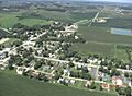
A view of Charlotte, Iowa.
-

Map showing Charlotte's location in Clinton County, Iowa.
See also
 In Spanish: Charlotte (Iowa) para niños
