
Chesapeake, Ohio facts for kids
Quick facts for kids
Chesapeake, Ohio
|
|
|---|---|
|
Village
|
|

Symmes Creek at its mouth
|
|

Location of Chesapeake, Ohio
|
|

Location of Chesapeake in Lawrence County
|
|
| Country | United States |
| State | Ohio |
| County | Lawrence |
| Township | Union |
| Government | |
| • Type | Mayor-council government |
| Area | |
| • Total | 0.56 sq mi (1.45 km2) |
| • Land | 0.47 sq mi (1.23 km2) |
| • Water | 0.09 sq mi (0.22 km2) |
| Elevation | 558 ft (170 m) |
| Population
(2020)
|
|
| • Total | 765 |
| • Estimate
(2023)
|
729 |
| • Density | 1,613.92/sq mi (623.70/km2) |
| Time zone | UTC-5 (Eastern (EST)) |
| • Summer (DST) | UTC-4 (EDT) |
| ZIP code |
45619
|
| Area code(s) | 740 |
| FIPS code | 39-13904 |
| GNIS feature ID | 2397614 |
Chesapeake is a small village located in Lawrence County, Ohio, United States. In 2020, about 765 people lived there. It sits right across the Ohio River from a bigger city called Huntington, West Virginia. Chesapeake is also where Symmes Creek flows into the Ohio River.
A special bridge, the Robert C. Byrd Bridge, connects Chesapeake to downtown Huntington, West Virginia. For a long time, this was the only bridge linking Ohio to Huntington across the Ohio River. Now, there are more bridges that connect to other parts of Huntington. Chesapeake is part of the larger Huntington-Ashland metropolitan area.
Contents
History of Chesapeake
The name Chesapeake comes from an old Algonquin word. It means "place where water is spread out." This name probably describes how the river looks near the village.
Geography of Chesapeake
Chesapeake is a small place, covering about 0.56 square miles (1.45 square kilometers). Most of this area is land, but a small part is water, mainly from the Ohio River and Symmes Creek.
Population and People
| Historical population | |||
|---|---|---|---|
| Census | Pop. | %± | |
| 1910 | 541 | — | |
| 1920 | 821 | 51.8% | |
| 1930 | 1,094 | 33.3% | |
| 1940 | 1,068 | −2.4% | |
| 1950 | 1,285 | 20.3% | |
| 1960 | 1,396 | 8.6% | |
| 1970 | 1,364 | −2.3% | |
| 1980 | 1,370 | 0.4% | |
| 1990 | 1,073 | −21.7% | |
| 2000 | 842 | −21.5% | |
| 2010 | 745 | −11.5% | |
| 2020 | 765 | 2.7% | |
| 2023 (est.) | 729 | −2.1% | |
| U.S. Decennial Census | |||
In 2010, there were 745 people living in Chesapeake. Most of the people were White (96.8%). A small number were African American, Native American, or Asian. About 0.9% of the population was Hispanic or Latino.
The average age of people in the village was about 44 years old. About 20% of the residents were under 18, and about 21% were 65 or older. There were slightly more females than males living in Chesapeake.
Community and Schools
Chesapeake has a public library, which is part of the Briggs Lawrence County Public Library system. This is a great place for students to find books and learn new things.
The village is served by the Chesapeake Union Exempted Village School District. This district has an elementary school, a middle school, and Chesapeake High School. Students in Chesapeake can attend these local schools.
Images for kids
-
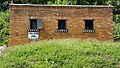
The Chesapeake Village jail was used from 1910 until 1961

See also
 In Spanish: Chesapeake (Ohio) para niños
