Chester Hill, Pennsylvania facts for kids
Quick facts for kids
Chester Hill, Pennsylvania
|
|
|---|---|
|
Borough
|
|

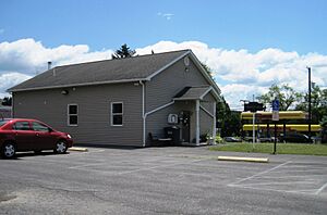
Borough hall and keystone marker
|
|

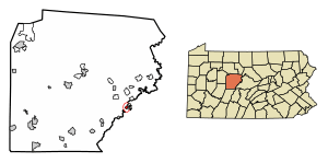
Location of Chester Hill in Clearfield County, Pennsylvania.
|
|

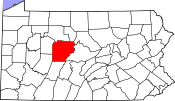
Map showing Clearfield County in Pennsylvania
|
|
| Country | United States |
| State | Pennsylvania |
| County | Clearfield |
| Settled | 1849 |
| Incorporated | 1883 |
| Government | |
| • Type | Borough Council |
| Area | |
| • Total | 0.48 sq mi (1.24 km2) |
| • Land | 0.44 sq mi (1.15 km2) |
| • Water | 0.04 sq mi (0.09 km2) |
| Elevation | 1,450 ft (440 m) |
| Population
(2020)
|
|
| • Total | 821 |
| • Density | 1,853.27/sq mi (716.17/km2) |
| Time zone | UTC-5 (Eastern (EST)) |
| • Summer (DST) | UTC-4 (EDT) |
| ZIP code |
16866
|
| Area code(s) | 814 |
| FIPS code | 42-13240 |
Chester Hill is a small town, known as a borough, located in Clearfield County, Pennsylvania, United States. It's a quiet community where about 821 people lived according to the 2020 census. The town was first settled in 1849 and officially became a borough in 1883.
Contents
Geography of Chester Hill
Chester Hill is found in the eastern part of Clearfield County. It sits on the west side of a stream called Moshannon Creek. Right across the creek, in a different county (Centre County), is the town of Philipsburg.
Location and Roads
A main road, Pennsylvania Route 53, goes right through Chester Hill. This road connects the borough to Philipsburg in the northeast and to Osceola Mills, about 3.7 miles (6 km) to the southwest. The exact location of Chester Hill is 40°53′30″N 78°13′44″W / 40.89167°N 78.22889°W.
Size of the Borough
Chester Hill covers a total area of about 0.48 square miles (1.23 square kilometers). Most of this area is land, about 0.44 square miles (1.14 square kilometers). A small part, about 0.04 square miles (0.09 square kilometers), is water, making up about 7.30% of the borough's total area.
People of Chester Hill
The number of people living in Chester Hill has changed over the years. Here's a quick look at how the population has grown and shrunk:
| Historical population | |||
|---|---|---|---|
| Census | Pop. | %± | |
| 1890 | 563 | — | |
| 1900 | 710 | 26.1% | |
| 1910 | 648 | −8.7% | |
| 1920 | 823 | 27.0% | |
| 1930 | 786 | −4.5% | |
| 1940 | 885 | 12.6% | |
| 1950 | 954 | 7.8% | |
| 1960 | 919 | −3.7% | |
| 1970 | 868 | −5.5% | |
| 1980 | 1,054 | 21.4% | |
| 1990 | 945 | −10.3% | |
| 2000 | 918 | −2.9% | |
| 2010 | 883 | −3.8% | |
| 2020 | 821 | −7.0% | |
| 2021 (est.) | 808 | −8.5% | |
| Sources: | |||
Population Details (2010 Census)
In 2010, there were 883 people living in Chester Hill. These people lived in 382 different homes, and 250 of these were families. On average, there were about 2.31 people in each home.
Most of the people in Chester Hill were White (96.9%). A small number were Black or African American (0.6%), Asian (0.9%), or from two or more races (1.4%). About 0.6% of the population identified as Hispanic or Latino.
Age Groups in Chester Hill
The population of Chester Hill includes people of all ages:
- About 26.6% of the people were under 18 years old.
- About 8.6% were between 18 and 24 years old.
- About 25.3% were between 25 and 44 years old.
- About 24.1% were between 45 and 64 years old.
- About 15.4% were 65 years old or older.
The average age of people in Chester Hill was 36 years.
Household Income
In 2010, the typical income for a household in Chester Hill was $26,500 per year. For families, the typical income was $49,375 per year. The average income per person in the borough was $17,320.
Some families and individuals in Chester Hill had lower incomes. About 23.9% of families and 33.0% of all people lived with incomes below what is considered the poverty line. This included 52.9% of those under 18 and 13.0% of those 65 or older.
See also
 In Spanish: Chester Hill para niños
 | George Robert Carruthers |
 | Patricia Bath |
 | Jan Ernst Matzeliger |
 | Alexander Miles |


