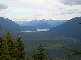
Chester Morse Lake facts for kids
Quick facts for kids Chester Morse Lake |
|
|---|---|

seen from Rattlesnake Mountain
|
|
| Location | King County, Washington |
| Coordinates | 47°23′13″N 121°42′01″W / 47.38694°N 121.70028°W |
| Primary inflows | North Fork of the Cedar River, South Fork of the Cedar River, and the Rex River |
| Primary outflows | Cedar River |
| Basin countries | United States |
| Surface elevation | 1,560 ft (475 m) |
Chester Morse Lake is a large lake in the state of Washington, United States. It was originally called Cedar Lake. This lake is a very important part of the Seattle area's water supply.
The lake's surface used to be 1,530 feet (466 m) above sea level. But in 1900, a dam was built on the Cedar River. This dam raised the lake's elevation to 1,560 feet (475 m). Chester Morse Lake is now more than four miles (6 km) long. It gets most of its water from the North and South Forks of the Cedar River and the Rex River.
Contents
How Chester Morse Lake Was Formed
Chester Morse Lake was once a natural lake named Cedar Lake. It formed about 14,000 years ago. This happened when a large glacier moved down the Cedar River valley. The glacier left behind a pile of rock and dirt called a terminal moraine. This moraine created a natural dam, forming the lake.
The Dam and Water Supply
Today, Chester Morse Lake is held back by a large masonry dam. There is also another control structure called the Overflow Dike. The lake now works as a huge storage tank for water. This water is used by people in the Seattle area. The dam also helps to power a 30-megawatt hydroelectric facility. This means it uses the force of moving water to create electricity.
Unique Fish in the Lake
Fish cannot easily travel upstream to Chester Morse Lake. This is because Cedar Falls naturally blocks their path. Because of this, the fish in Chester Morse Lake are special. They have been separated from other fish populations for at least 13,000 years.
Special Fish Species
Two unique types of fish live in Chester Morse Lake:
- Bull trout: These fish are a type of char.
- Pygmy whitefish: These are small, slender fish.
Both of these fish populations are genetically unique. This means they are different from other bull trout and pygmy whitefish found elsewhere. These fish usually stay in the deeper parts of the lake.
Lake Level Changes and Habitat
The water level of Chester Morse Lake changes a lot each year. It can go up or down by about 20 feet. These changes affect the plants and animals living near the Cedar and Rex river deltas. When the lake level stays higher, some plants like sedges and willows move further up the shore. Also, when the lake floods the river channels, it can cause dirt to settle. This might harm the eggs of bull trout. Scientists are studying these effects.
Other Lakes in the Watershed
The Cedar River Watershed has other interesting lakes.
Walsh Lake
Walsh Lake is the largest lake in the lower part of the watershed. It covers 68 acres. This lake has the most types of fish of all the lakes in the watershed. There are 11 different species found here.
A special type of fish called kokanee lives in Walsh Lake. Kokanee are a form of sockeye salmon that live their whole lives in freshwater. They spawn, or lay their eggs, in Webster Creek, which flows into Walsh Lake. Researchers from the University of Washington say that Walsh Lake is one of the most natural lakes in the Puget Sound area.
Images for kids
 | Janet Taylor Pickett |
 | Synthia Saint James |
 | Howardena Pindell |
 | Faith Ringgold |


