Chesterfield Inlet facts for kids
Quick facts for kids Chesterfield Inlet |
|
|---|---|

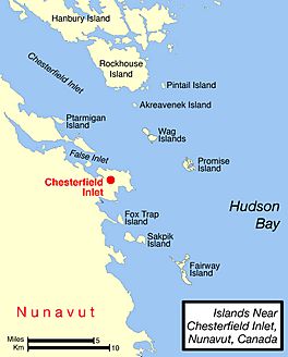
Map of Chesterfield Inlet area.
|
|
| Location | Hudson Bay |
| Coordinates | 63°32′24″N 091°04′48″W / 63.54000°N 91.08000°W |
| River sources | Thelon River |
| Basin countries | Canada |
| Settlements | Chesterfield Inlet, Nunavut |
Chesterfield Inlet is a long, narrow arm of the sea located in Nunavut, Canada. In the Inuit language, it is called Igluligaarjuk. This name means "place with a few houses" or "small house". It is found in the Kivalliq Region of Nunavut.
This inlet is a part of the northwestern Hudson Bay. It is also where the Thelon River ends its journey. The river flows into Chesterfield Inlet after passing through a large body of water called Baker Lake. About 30 kilometers (18.6 miles) east of Baker Lake, the inlet widens into an area known as Cross Bay. You can also find several islands within the inlet.
Exploring Chesterfield Inlet
Chesterfield Inlet was first explored by Europeans in the 1700s. In 1747, a man named William Moor sent small boats to explore about 60 miles (97 km) up the inlet. Later, in 1762, William Christopher traveled the entire length of the inlet. He reached Baker Lake, mapping the waterway completely.
The Hamlet of Chesterfield Inlet
Near the mouth of the waterway, there is a small community. It is also called Chesterfield Inlet. This community is a hamlet, which is a small village. In the past, this area was home to different groups of Inuit people. These groups included the Aivilingmiut and the Qaernermiut. They lived and hunted in this region for many years.
See also
 In Spanish: Chesterfield Inlet para niños
 | Toni Morrison |
 | Barack Obama |
 | Martin Luther King Jr. |
 | Ralph Bunche |


