
Chilkoot River facts for kids
Quick facts for kids Chilkoot River |
|
|---|---|

Chilkooot River from the Chilkoot Lake outlet
|
|
| Lua error in Module:Location_map at line 420: attempt to index field 'wikibase' (a nil value).
Location of the mouth of the Chilkoot River in Alaska
|
|
| Country | US |
| Physical characteristics | |
| Main source | Takshanuk Mountains of Haines Borough, Alaska |
| River mouth | Chilkoot Inlet into the Lynn Canal 30 feet (9.1 m) |
| Length | 20 miles (32 km) |
| Basin features | |
| River system | Chilkoot River Watershed |
| Basin size | Alaska, USA |
The Chilkoot River is a river in Southeast Alaska, United States. It flows for about 20 miles (32 km) and drains an area of 100 square miles (260 km2). The river starts in the Takshanuk Mountains and from glaciers.
The upper part of the river flows for about 16 miles (26 km) into Chilkoot Lake. From the lake, the lower part of the river flows for about 1.5 miles (2.4 km). It then empties into Chilkoot Inlet, which is part of the Lynn Canal.
Long ago, a village of the Chilkoot Indian people was located by the lake. The river and lake are named after this historic settlement.
.jpeg)
Today, the Chilkoot River area is carefully watched over. This is done by the Chilkoot River Corridor Strategic Planning Project. Their goal is to protect its nature and history. A special fence, called a fishing weir, helps count fish. This weir tracks fish moving from the lake into the river and inlet.
Contents
River's Journey


The Chilkoot River starts in the Takshanuk Mountains. It also gets water from the Ferebee glacier and other mountains. The river has three main parts.
The "Upper Reach" is the first part of the river. It flows from the glaciers down to the lake. This part of the river is not easy to travel on. It has many rocks and log jams.
The "Chilkoot Lake" is the middle part of the river. It is about 2.5 miles (4.0 km) long and 1 mile (1.6 km) wide. The lake is quite deep, reaching about 300 feet (91 m). You can use boats on the lake. Canoes are best because it can be windy.
The "Lower Reach" is the last part of the river. It flows from Chilkoot Lake to the Lynn Canal. This section is about 1.5 miles (2.4 km) long. It is a small stream, about 3.6 yards (3.3 m) wide and 2 feet (0.61 m) deep. Boats can travel on part of this section when the tides are high.
The river and lake are popular for fishing. Many people come to catch coho, pink, chum, Dolly Varden, and sockeye salmon. The road to the river is even called the 'Bear Highway'. This is because brown bears often visit to catch salmon.
River's Past
The Chilkoot River and Chilkoot Lake have a rich history. They were traditionally owned by the L’uknax Adi clan of the Tlingit people. Their special symbol was the red salmon. Another Tlingit group, the Jilkoot Kwaan, also lived nearby.
The river and lake are named after the Chilkoot village. This village was a very important place for the Tlingit people. They settled there long ago to fish for salmon and hooligan. Hooligan fish were used to make fish oil for cooking.
The word Chilkoot comes from the Tlingit language. It means without a storehouse. This is because the Chilkoot people used to store their fish in snow, not in buildings.
Over time, fewer people lived in the village. By the 1940s, it was empty. Many Tlingit families moved to Haines. This happened partly because canneries were built to process salmon. Also, fishing tools changed from nets to modern rods and reels.
In 1976, a fishing weir was built on the lower Chilkoot River. This helped biologists count the sockeye salmon moving downstream from the lake. Roads were also improved in the 1950s and 1960s. This made it easier to reach the river for fishing and timber.
Boats were once used by the Tlingit for fishing and hunting. Later, they carried building materials. Today, commercial boats offer tours for fishing and sightseeing.
Animals of the River

The Chilkoot River is full of amazing wildlife. You can see Bald eagles, harbor seals, and bears. Mountain goats live on the hillsides. Many of these animals come to the river to feed on salmon.

The most common fish is the Sockeye salmon. Studies show that many sockeye salmon lay their eggs in the river's upper parts. Other fish like coho, Dolly Varden, and chum salmon are also found here.
Bald Eagles are a common sight from May to September. They perch on trees and rocks, or fly overhead. Brown Bears are often seen in spring and early summer. They come to the river to eat salmon.
A special sign near the river explains the "Salmon Forest." It shows how salmon are vital to the ecosystem. They are food for eagles, bears, gulls, and other animals. These animals then carry salmon nutrients into the forest, helping plants grow.
Traditional Fishing Tools
The Tlingit tribes used special tools to catch fish. One tool was a long-handled scoop net called go qtc. It was about 18 inches (46 cm) wide and 10 feet (3.0 m) deep. They used it from a canoe, scooping fish from the riverbed.
Another method involved building rock walls in the river. These walls created small channels. A fisherman would stand on a platform and use a gaff hook to catch salmon. Today, most people use modern fishing rods and reels.
Counting Fish

The Alaska Department of Fish and Game built a fishing weir on the Chilkoot River in 1976. This weir is a fence that helps count the sockeye salmon. It allows biologists to see how many fish pass through from the lake. This helps them manage the fish population.
Chilkoot Lake Fun
The Chilkoot Lake State Recreation Site is a great place for outdoor fun. It is managed by the Alaska Department of Natural Resources. The site is located in a forest of Sitka trees, right on the southern shore of Chilkoot Lake.
It's about 10 miles (16 km) from Haines. The site has 80 acres (32 ha) of land with 32 campsites and picnic areas. There is also a boat launch.
Camping and More
The old Chilkoot village site has been turned into a camping area. It's a peaceful spot for visitors.
Besides camping, the lower Chilkoot River hosts a fun event. It's called the “Mad Raft Race.” This race happens every year during Fourth of July celebrations in Haines. People use homemade rafts, which are light and easy to move.
Protecting the River
The Chilkoot River Corridor (CRC) is a special area. Many Alaskan brown bears visit it in August and September to eat salmon. This also attracts many visitors who want to watch bears and bald eagles.
To keep both people and bears safe, a project was started. It's called the Chilkoot River Corridor Strategic Planning Project. Its main goal is to manage the area's natural, cultural, and historical resources for the long term.
Important Rules
To protect the area, some rules have been made. These rules help manage visitors and protect wildlife. They also aim to preserve the historical sites and Tlingit culture.
One key rule is about human-wildlife conflicts. People should not do anything that attracts bears. This includes leaving food or garbage out. Bears should be allowed to feed without being disturbed. Firearms should only be used for self-defense or legal hunting. They should not be used to scare bears away. These rules help everyone enjoy the Chilkoot River safely.
Images for kids
-
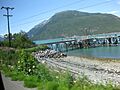
Chilkoot Inlet and the harbour
-
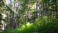
Chilkoot catchment covered with rain forests


