
Chittoor district facts for kids
Chittoor district is a cool place in the Rayalaseema region of Andhra Pradesh, an Indian state. The main city and headquarters of the district is Chittoor.
In 2011, about 4,170,468 people lived here. Chittoor district is famous for its many important temples. Two of the most well-known are the Tirupati Temple and the Kanipakam Temple.
The district is located in the Poini river valley in the southern part of Andhra Pradesh. It's also along a big highway that connects Chennai and Bangalore. Chittoor is a major trading spot. You can find lots of mangoes, grains, sugarcane, and peanuts here.
How Many People Live Here?
According to the 2011 census, Chittoor district had a population of 4,170,468 people. This made it the 47th most populated district out of 640 in India. It was also the 6th most populated district in its own state.
About 275 people lived in every square kilometer of the district. Between 2001 and 2011, the population grew by about 11.33%. For every 1000 boys, there were 1002 girls, which is called the sex ratio. Also, about 72.36% of the people could read and write, which is called the literacy rate.
In 2007–2008, a study looked at homes in Chittoor district. They found that most homes (92.7%) had electricity. Almost everyone (99.6%) had drinking water. About 33.3% of homes had toilet facilities. More than half (53.8%) of the people lived in a strong, permanent home.
The main language spoken and used officially in Chittoor district is Telugu.
Images for kids
-
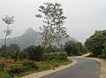
Road to Kanipakam
-
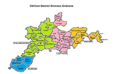
Map showing different parts of Chittoor District
-
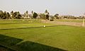
Farms and agriculture near Chittoor


See also
 In Spanish: Distrito de Chittoor para niños
