
Andhra Pradesh facts for kids
.svg)
Andhra Pradesh (Telugu: ఆంధ్ర ప్రదేశ్) is a state in the Republic of India. It's home to about 75.7 million people, based on the 2001 census. The state has a long coastline of about 600 miles along the Bay of Bengal in the east. Andhra Pradesh covers an area of about 106,195 square miles. It's bigger than Burkina Faso but smaller than Ecuador. In traditional Indian maps, it's considered part of South India.
The capital city of Andhra Pradesh is Hyderabad. Andhra Pradesh is a very important state for India's economy. Its total economic output (called Gross Domestic Product or GDP) is 123.56 billion US dollars. This makes it the third-largest economy among Indian states, after Maharashtra and Uttar Pradesh. Andhra Pradesh is also known as the "Rice Bowl of India" because it produces so much rice. The state is located at 17.3660°N latitude and 78.4760°E longitude.
Contents
History
How Andhra Pradesh Got Its Name
Long ago, a group of people called the Andhra tribe were mentioned in old Indian texts, like the Aitareya Brahmana (around 800–500 BCE). These texts say that the Andhras moved from northern India and settled in the south. Later, a powerful family called the Satavahanas were also called "Andhra" in ancient stories. It's thought they were called this because of their family background or because their kingdom included the Andhra region.
Ancient and Medieval Times

Old discoveries from places like Amaravati show that the Andhra region was once part of the big Maurya Empire. Amaravati might have been an important center for the Mauryan rulers. After Emperor Ashoka died around 200 BCE, the Mauryan Empire became weaker. Smaller kingdoms then took over in the Andhra region.
The Satavahana dynasty was very powerful in the Deccan region from the 1st century BC to the 3rd century. Later, the Satavahanas made Dharanikota and Amaravathi their capital cities. It's believed that Nagarjuna, a famous Buddhist thinker, lived there in the 2nd and 3rd centuries.
Another old family, the Salankayanas, ruled the Andhra region between the Godavari and Krishna rivers from 300 to 440 CE. Their capital was Vengi, which is modern-day Pedavegi.
The Kakatiyas ruled Andhra Pradesh for almost 200 years and built many forts. After them came the Musunuri Nayaks.
The Reddy dynasty (1325–1448 CE) was started by Prolaya Vema Reddi in the early 14th century. They ruled from what is now Kondaveedu.


The Vijayanagara Empire began in the Deccan Plateau in the early 14th century. It was founded in 1336 by two brothers, Harihara Raya I and Bukka Raya I.
Modern History
In 1347 CE, a new independent Muslim kingdom, the Bahmani Sultanate, was formed in south India. This happened when Ala-ud-Din Bahman Shah rebelled against the Delhi Sultanate. The Qutb Shahi dynasty then ruled the Andhra region for about 200 years, from the early 1500s to the late 1600s.
In the early 1800s, the Northern Circars region was given to the British East India Company. This area became part of the Madras Presidency and is now known as the Coastal Andhra region. Later, the Nizam rulers of Hyderabad gave five more areas to the British. These areas became the Rayalaseema region. The Nizams kept control of their inner provinces as the princely state of Hyderabad. They agreed to British rule but kept their local freedom. However, Komaram Bheem, a tribal leader, fought against the rulers of Hyderabad for freedom. Meanwhile, the French controlled Yanam, a town in the Godavari delta, until 1954. In 1947, Vizianagaram was the largest Hindu princely state in Andhra Pradesh.
India became independent from the United Kingdom in 1947. The Nizam wanted Hyderabad State to remain independent from India. But the people of Hyderabad wanted to join India. So, Hyderabad was made part of India by force in 1948 through an action called Operation Polo.
After Independence
In February 2014, the Parliament of India passed a law called the Andhra Pradesh Reorganisation Act, 2014. This law created the new state of Telangana by separating ten districts from Andhra Pradesh. Hyderabad was made a shared capital for both states for up to ten years. The new state of Telangana officially started on June 2, 2014, after the President of India approved it.
Geography


Andhra Pradesh has many different types of land, from the hills of the Eastern Ghats and Nallamala Hills to the sandy shores of the Bay of Bengal. This variety supports many different plants and animals. Two major rivers, the Krishna and Godavari, flow through the state. The coastline stretches along the Bay of Bengal from Srikakulam to Nellore district. The flat lands east of the Eastern Ghats are called the Eastern coastal plains. These plains are mostly delta regions formed by the Godavari, Krishna, and Penner Rivers. The Eastern Ghats are not a continuous mountain range; they have breaks and different local names. They form an important dividing line in the state's geography. The Kadapa Basin, formed by two parts of the Eastern Ghats, is rich in minerals. The coastal plains are mostly used for farming. The Rayalaseema region has dry, semi-desert-like conditions.
Nature and Wildlife

The Andhra Pradesh Forest Department works to protect and manage the state's forests. After the state was divided, Andhra Pradesh now has about 22,862 square kilometers of forest cover. The forests can be divided into four main types:
- Deccan Plateau
- Central Plateau
- Eastern Highland
- East Coastal Plains
The Eastern Ghats region has thick tropical forests. As you move away from the Ghats towards the Deccan Plateau, the trees become fewer, and you see more bushes. The plants found in the state are mostly dry deciduous types, including trees like teak, Terminalia, Dalbergia, Pterocarpus, and Anogeissus.
The state has many wildlife sanctuaries, national parks, and zoological parks. Some famous ones are Coringa, Krishna Wildlife Sanctuary, Nagarjunsagar-Srisailam Tiger Reserve, Kambalakonda Wildlife Sanctuary, Sri Venkateswara Zoological Park, and Indira Gandhi Zoological Park. Bird sanctuaries like Atapaka Bird Sanctuary, Nelapattu Bird Sanctuary, and Pulicat Lake Bird Sanctuary attract many birds that travel long distances.
Andhra Pradesh is home to some rare plants like Cycas beddomei and Pterocarpus santalinus. The animal life includes tigers, panthers, hyenas, black bucks, deer, sambars, sea turtles, and many types of birds and reptiles. The areas where the Godavari and Krishna rivers meet the sea have rich mangrove forests, which are home to fishing cats and otters.
Climate
The weather in Andhra Pradesh changes a lot depending on the area. Summers are from March to June. In the coastal areas, summer temperatures are usually higher, ranging from 20°C to 41°C. July to September is the season for tropical rains. About one-third of the total rainfall comes from the northeast monsoon. In October and November, low-pressure systems and tropical cyclones form in the Bay of Bengal. These, along with the northeast monsoon, bring rains to the southern and coastal parts of the state.
November, December, January, and February are the winter months. Since the state has a long coastline, winters are not very cold. Winter temperatures are generally between 12°C and 30°C. Lambasingi in Visakhapatnam district is the only place in South India that gets snowfall. This is because it is located about 1,000 meters above sea level. It is also called the Kashmir of Andhra Pradesh, and its temperature ranges from 0°C to 10°C.
People and Cities
Largest cities of Andhra Pradesh


- Visakhapatnam - population 1,735,922
- Vijayawada - population 1,434,358
- Guntur - population 743,354
- Nellore - population 600,869
- Kurnool - population 424,920
- Kadapa - population 343,054
- Rajahmundry - population 341,831
- Kakinada - population 312,538
- Tirupati - population 287,482
- Eluru - population 283,648
In 2014, the population of Andhra Pradesh was about 49.6 million people, with about 304.5 people living per square kilometer.

| Religion in Andhra Pradesh | ||||
|---|---|---|---|---|
| Religion | Percent | |||
| Hinduism | 90.87% | |||
| Islam | 7.32% | |||
| Christianity | 1.38% | |||
| Others | 0.43% | |||


Andhra Pradesh ranks tenth among all Indian states in the Human Development Index, which measures things like health, education, and living standards. In 2001, Krishna, West Godavari, and Chittoor were the rural districts with the highest Human Development Index scores.
Languages
The main and official language of Andhra Pradesh is Telugu. The government has even declared Telugu a "Classical Language" because of its long history and rich literature.
Religions
Most people in Andhra Pradesh are Hindus. Muslims make up a significant group, and there are also Christians. According to the 2011 census, Hindus are 90.87%, Muslims are 7.32%, and Christians are 1.38%. Other religions like Buddhists, Sikhs, and Jains make up a small part of the population.
- Hinduism
The Sri Venkateswara Temple at Tirupati is one of the richest temples in the world. Millions of devotees visit it every year. Andhra Pradesh is also home to many Hindu saints like Yogi Vemana and Sri Sathya Sai Baba.
- Buddhism

Buddhism came to Andhra Pradesh very early. The Krishna River valley was a place of great Buddhist activity for almost a thousand years. Ancient Buddhist sites like Amaravati and Nagarjunakonda date back to at least the third century BCE. The region was very important in the development of Mahayana Buddhism.
Administrative Divisions
Regions
Andhra Pradesh is divided into two main regions:
- Kosta
- Rayalaseema
Smaller Divisions
The state has 50 revenue divisions, which are then divided into 670 smaller areas called mandals. Chittoor district has the most mandals (66), while Vizianagaram has the fewest (34).
Cities
There are a total of 31 cities in Andhra Pradesh. This includes 16 municipal corporations and 14 municipalities. Two cities, Visakhapatnam and Vijayawada, have more than one million people living in them.
Economy


Andhra Pradesh was ranked eighth among Indian states in terms of its total economic output (called GSDP) for the financial year 2014–2015. The state's economy is growing. The agriculture sector contributes a lot, as does the industrial sector. The service sector (like IT and tourism) contributes the most to the state's economy. In 2010, Forbes magazine listed several people from Andhra Pradesh among the top 100 richest Indians.
Agriculture

Andhra Pradesh's economy relies heavily on farming and raising livestock. Four important rivers – the Godavari, Krishna, Penna, and Thungabhadra – flow through the state and provide water for irrigation. About 60% of the population works in agriculture. Rice is the main food crop and the staple food here. The state exports many farm products and is known as the "Rice Bowl of India." There are special farming zones for mango pulp and vegetables in Chittoor district, mangoes in Krishna district, and chilies in Guntur district.
Besides rice, farmers also grow jowar, bajra, maize, other grains, many types of pulses (like lentils and beans), oil seeds, sugarcane, cotton, chili pepper, mangoes, and tobacco. Crops used for making vegetable oil, such as sunflower and peanuts, are also popular. Many large irrigation projects are being built, including the Godavari River Basin Irrigation Projects and Nagarjuna Sagar Dam.
Raising livestock and poultry is also a profitable business. The state is the largest producer of eggs in India, earning it the nickname "Egg Bowl of Asia."
Fishing is also very important. Andhra Pradesh produces 10% of India's total fish and over 70% of its shrimp. The state's location along the coast allows for both sea fishing and inland fish farming. Vannamei shrimp are a major export.
Industries

Andhra Pradesh has important industries like pharmaceuticals, automobiles, and textiles. Sricity in Chittoor district is a big business hub with many famous companies like PepsiCo, Isuzu Motors, Cadbury India, Kellogg's, Colgate-Palmolive, and Kobelco. PepsiCo has its largest plant in India at Sri City.
The state is also growing in information technology (IT) and biotechnology. Visakhapatnam's IT earnings were high in 2012–2013. IT development is also improving in smaller cities like Vijayawada, Kakinada, and Tirupati.
Natural Resources
Andhra Pradesh is rich in mineral resources. Its varied geology means it has many different industrial minerals and building stones.
Andhra Pradesh is a top state in India for mica deposits and production. Other minerals found here include limestone, oil and natural gas, manganese, asbestos, iron ore, gold, diamonds, graphite, and quartz. It has about one-third of India's limestone reserves and is known for its large deposits of barytes and galaxy granite, which are popular internationally.
Mining Mining is a key area for the state's industrial growth. The Tummalapalle Uranium mine in Andhra Pradesh has confirmed 49,000 tonnes of uranium ore, and there might be three times more. There are also 700 million tonnes of bauxite deposits near Visakhapatnam Port.
Reliance Industries Limited found huge natural gas reserves in the KG basin, about 150 km off the Andhra Pradesh coast near Kakinada. This discovery is expected to bring fast economic growth. In 2016, about 134 trillion cubic feet of methane hydrate deposits were found in the KG basin. Extracting this could provide India with energy for many decades.
Power Plants The state is a leader in solar power generation. APGENCO is the state-owned company that generates power. Andhra Pradesh now produces more electricity than it needs and exports the extra power to other states.

By 2015, the state had power plants (using natural gas and coal) and renewable power plants that could generate a total of 21,000 MW.
Culture
Andhra Pradesh has a rich culture and heritage. Kuchipudi, the state dance, started in the village of Kuchipudi in Krishna district. It even set a Guinness World Records for a performance with 6,117 dancers in Vijayawada. The state has many special products that have "geographical indications" (GI tags), meaning they are unique to this region. These include Banaganapalle Mangoes and Bandar laddu. Other GI-tagged items are Bobbili Veena, Kondapalli Toys, Machilipatnam Kalamkari, and Tirupati Laddu.
Arts and Crafts

Machilipatnam and Srikalahasti Kalamkari are two unique textile art forms practiced in India. There are also other notable handicrafts, like the soft limestone carvings from Durgi. Etikoppaka in Visakhapatnam district is famous for its Lac industry, which makes lacquered wooden toys.
The state has many museums that display ancient sculptures, paintings, idols, weapons, and religious items. Examples include the Amaravati Archaeological Museum, Visakha Museum, and the Victoria Jubilee Museum in Vijayawada.
Music and Films

Many famous composers of Carnatic music, like Annamacharya and Bhadrachala Ramadas, were from the Telugu region. Modern Carnatic music singers like Ghantasala and M. Balamuralikrishna are also of Telugu descent.
Food
The traditional sweet of Telugu people, Pootharekulu, originated from Atreyapuram village in Andhra Pradesh.

Tourism
Andhra Pradesh has several beautiful beaches along its coast, such as Rushikonda, Mypadu, and Suryalanka. It also has interesting caves like Borra Caves, Indian rock-cut architecture depicting Undavalli caves, and the country's second-longest caves, Belum Caves. The state also has scenic valleys and hills, including Araku Valley, Horsley Hills, and Papi Hills. Arma Konda peak in Visakhapatnam district is the highest peak in the Eastern Ghats.
The state is home to many religious places. These include Tirumala Temple, Simhachalam Temple, Annavaram, Srisailam temple, Kanaka Durga Temple, and Srikalahasti. There are also Buddhist centers at Amaravati and Nagarjuna Konda.
Transport
Andhra Pradesh is well connected to other states by roads and railways. It also connects to other countries through airports and seaports. With a long coastline along the Bay of Bengal, it has many ports for sea trade. The state has one of the largest railway junctions at Vijayawada and one of the largest seaports at Visakhapatnam.
Roads


Roads in Andhra Pradesh include National Highways, state highways, and district roads. The Andhra Pradesh State Road Transport Corporation (APSRTC) is the main public bus service, running thousands of buses across the state. The Pandit Nehru Bus Station (PNBS) in Vijayawada is one of the largest bus terminals in Asia.
Railways


Andhra Pradesh has a total railway route of 3703.25 km for broad gauge trains. The state's railway density is 16.59 km per 1,000 km, which is lower than the Indian average. The Howrah–Chennai main line, which passes through the state, is planned to be upgraded into a high-speed rail corridor.
The railway network is managed by two zones of Indian Railways. These include the Vijayawada, Guntur, and Guntakal railway divisions of the South Central Railway zone, and the Waltair railway division of the East Coast Railway zone. There is a request to create a single railway zone for the state based in Visakhapatnam.
There are three A1 category and twenty-three A-category railway stations in the state. Visakhapatnam railway station has been named the cleanest railway station in the country. The railway station of Shimiliguda was the first highest broad gauge railway station in India.
Airports


Visakhapatnam Airport is the only airport in the state with international flights. Vijayawada Airport at Gannavaram is also expected to start international flights soon. The state has four other domestic airports at Rajahmundry, Renigunta, Cuddapah, and a private airport at Puttaparthi. There are also 16 smaller airstrips in the state.
Sea Ports

Andhra Pradesh has one of India's largest ports at Visakhapatnam, based on the amount of cargo it handles. Other important ports are Krishnapatnam Port (Nellore), Gangavaram Port, and Kakinada Port. Gangavaram Port is a deep seaport that can handle very large ocean liners. There are also 14 smaller ports along the coast.
Education and Research
Andhra Pradesh has a literacy rate (people who can read and write) of 67.41% as per the 2011 Indian census. Education from primary to secondary levels is provided by government, aided, and private schools. The main languages of instruction are Telugu and English, but also Urdu, Hindi, Kannada, Odia, and Tamil.
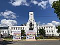
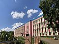
Higher education is managed by the Department of Higher Education. There are central universities like All India Institute of Medical Sciences, IIM Visakhapatnam, IIT Tirupati, and National Institute of Technology Andhra Pradesh. The Government of Andhra Pradesh started Rajiv Gandhi University of Knowledge Technologies (RGUKT) in 2008 to help rural youth get an education. Some universities like GITAM and K L University are considered "Deemed Universities." There are 18 state universities offering higher education in subjects like farming, law, medicine, technology, and veterinary science. Andhra University, established in 1926, is the oldest university in the state.
Research
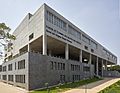
Both the central and state governments have set up research institutes. Some important ones include the Naval Science & Technological Laboratory (NSTL), National Institute of Oceanography in Visakhapatnam, and the School of Planning and Architecture at Vijayawada. The National Atmospheric Research Laboratory studies the atmosphere and space. The Central Tobacco Research Institute in Rajahmundry researches tobacco for farmers. The Indian Institute of Oil Palm Research (IIOPR) near Eluru focuses on oil palm.
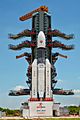
Space Research
The Indian Space Research Organisation (ISRO) has its main satellite launching station at Sriharikota in Nellore district of Andhra Pradesh. India's lunar orbiter, Chandrayaan-1, was launched from here on October 22, 2008.
Sports
The Sports Authority of Andhra Pradesh is in charge of developing sports facilities for cricket, field hockey, association football, Olympic weightlifting, chess, water sports, tennis, badminton, table tennis, and cycling.
Cricket is one of the most popular sports in the state.
Provincial symbols of Andhra Pradesh
-
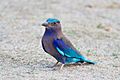
Provincial bird of Andhra Pradesh
-
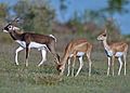
Provincial animal of Andhra Pradesh
-
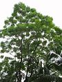
Provincial tree of Andhra Pradesh
-
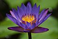
Provincial flower of Andhra Pradesh


Images for kids
-
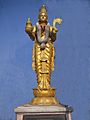
Telugu Thalli
-
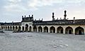
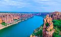
Gandikota fort view
-
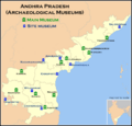
Archaeological Museums map of Andhra Pradesh
-
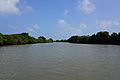
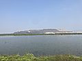
Mangrove forest near Kakinada
-
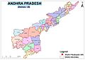
Andhra Pradesh Political Map
-
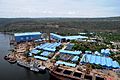
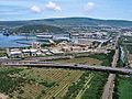
Aerial View of Hindustan Shipyard Limited (HSL)
-
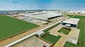
Isuzu Motors India manufacturing plant aerial view
-
IBM-Software-IconicCampus-Visakhapatnam
-
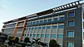
CELKON Manufacturing plant at Tirupati
-
Mangampet Barytes
-
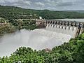
Srisailam Hydel power project
-
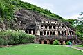
Undavalli Caves, a monolithic example of Indian rock-cut architecture
-
Gandikota Canyon
-
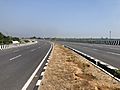
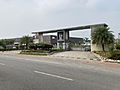
NH 140 near Tirupati
-
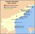
Map of seaports in Andhra Pradesh
-
Visakhapatnam seaport
-
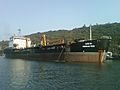
A ship at the Visakhapatnam port
-
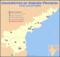
Map of universities in Andhra Pradesh
-
Agriculture University, Guntur
-
ICI Tirupati
-
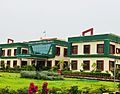
SVU Admin Building
-
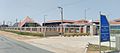
S V Agricultural College Tirupati
-
SPA Vijayawada
-
Satish Dhawan Space Centre [SDSC], Sriharikota, Tirupati
-
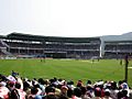
Dr. Y. S. Rajasekhara Reddy ACA–VDCA Cricket Stadium in Visakhapatnam
-
Map of Andhra Pradesh
-
Map of Sugar industries in Andhra Pradesh


.jpg)


See Also
 In Spanish: Andhra Pradesh para niños
