
Godavari River facts for kids
Quick facts for kids Godavari River |
|
|---|---|

The Godavari bridge across the Godavari in Rajahmundry at East Godavari district
|
|

Path of the Godavari through the South Indian Peninsula
|
|
| Country | India |
| State | Maharashtra, Telangana, Andhra Pradesh, Chhattisgarh, Odisha |
| Region | West India and South India |
| Physical characteristics | |
| Main source | Brahmagiri Mountain, Trimbakeshwar, Nashik, Maharashtra, India 920 m (3,020 ft) 19°55′48″N 73°31′39″E / 19.93000°N 73.52750°E |
| River mouth | Bay of Bengal Antarvedi,Konaseema district Andhra Pradesh, India 0 m (0 ft) 17°0′N 81°48′E / 17.000°N 81.800°E |
| Length | 1,465 km (910 mi) |
| Discharge (location 2) |
|
| Discharge (location 3) |
|
| Basin features | |
| Basin size | 312,812 km2 (120,777 sq mi) |
| Tributaries |
|
The Godavari River is the second longest river in India, after the Ganga. It flows into the third largest river basin in India, covering about 10% of India's total land area. The river starts in Trimbakeshwar, Nashik, Maharashtra. It flows east for 1,465 kilometres (910 mi), passing through the states of Maharashtra (48.6%), Telangana (18.8%), Andhra Pradesh (4.5%), Chhattisgarh (10.9%), and Odisha (5.7%). Finally, the Godavari empties into the Bay of Bengal through many smaller rivers that branch off.
Its basin is huge, covering about 312,812 km2 (120,777 sq mi). This makes it one of the largest river basins in the Indian subcontinent, with only the Ganga and Indus rivers having bigger basins. The Godavari is the largest river in peninsular India in terms of length, area it covers, and water flow. It is often called the Dakshina Ganga (which means "Ganges of the South").
People have respected the Godavari River in Hindu holy books for thousands of years. It continues to support a rich culture. In recent decades, several barrages and dams have been built on the river. These structures help control the water level and reduce how much water evaporates. The wide river delta near the sea is home to many people, almost twice the average population density of India. This area also faces a high risk of flooding, which could get worse if global sea levels rise.
Contents
- The River's Journey
- Water Flow and Discharge
- Tributaries of the Godavari
- Religious Importance
- Towns and Cities Along the Godavari
- Places of Interest Along the Godavari
- Wildlife and Nature
- Waterfalls of Godavari Basin
- Bridges Across the Godavari
- Dams on the Godavari
- Hydro Power Stations
- Environmental Concerns
- Images for kids
- Read More
- See also
The River's Journey


The Godavari River begins in the Western Ghats of central India, near Nashik in Maharashtra. This is about 80 km (50 mi) from the Arabian Sea. It flows for 1,465 km (910 mi). First, it goes east across the Deccan Plateau. Then, it turns southeast, entering the Eluru district and Alluri Sitharama Raju district of Andhra Pradesh. Finally, it splits into two main branches that form a large river delta at Dhavaleshwaram Barrage in Rajamahendravaram, before flowing into the Bay of Bengal.
The Godavari River basin covers an area of 312,812 km2 (120,777 sq mi). This is almost one-tenth of India's total area. It's like the size of the United Kingdom and Republic of Ireland combined! The river basin is divided into three main parts:
- Upper (from its source to where it meets the Manjira)
- Middle (between where it meets the Manjira and the Pranhita)
- Lower (from where it meets the Pranhita to its mouth at the sea)
These three sections make up about 24.2% of the total basin area. The river's average annual water flow is about 110 billion cubic meters. About half of this water is currently used. How the water is shared among the states is decided by the Godavari Water Disputes Tribunal. The Godavari has some of the highest flood flows in India. In 1986, it had a record flood of 3.6 million cusecs (a measure of water flow). An annual flood of 1.0 million cusecs is considered normal.
Journey Through Maharashtra
In Maharashtra state, where it starts, the Godavari River flows for a long distance. The upper part of its basin (from its source to where it meets the Manjira) is entirely within Maharashtra. This area drains about 152,199 km2 (58,764 sq mi), which is about half the size of Maharashtra.
In Nashik district, the river flows northeast until it reaches the Gangapur Reservoir. This reservoir, along with the Kashypi Dam, provides potable water (drinking water) to Nashik, a large city on the river's banks. As the river flows out of the dam, about 8 km (5.0 mi) upstream from Nashik, it goes over a rocky bed with many drops and ledges. This creates two important waterfalls: the Gangapur and the Someshwar waterfalls. The Someshwar waterfall is also known as the Dudhsagar Waterfall.
About 10 km (6.2 mi) east of Gangapur, the river passes the town of Nashik. Here, it collects water from the Nasardi River, which joins it from the right. About 0.5 km (0.31 mi) south of Nashik, the river sharply bends east. It flows past a high cliff that used to have a Mughal fort, but floods are slowly eroding it away. About 25 km (16 mi) below Nashik, the Godavari meets one of its tributaries, the Darna.
For most of the year, the river flows as a small stream in a wide, gravelly bed. The banks are about 4 to 6 m (13 to 20 ft) high and covered with black soil. A few kilometers after meeting the Darna, the Godavari turns northeast. Then, the Banganga joins it from the northwest on the left side. The main river then turns more to the south. At Nandur-Madhmeshwar, the Kadva, another large river, adds a lot more water to the Godavari.
The river then begins its southeast flow, which is typical for rivers on the Deccan Plateau. It leaves the Niphad Taluka of Nashik and enters the Kopargaon taluka, in Ahmednagar District. In Ahmednagar District, the river quickly flows past the town of Kopargaon and reaches Puntamba. After this, the river forms a natural border between several districts:
- Ahmednagar and Aurangabad: Here, it receives its first major tributary, the Pravara River, which drains the Ahmednagar district. They meet at Pravarasangam.
- Beed and Jalna
- Beed and Parbhani: Here, it meets the Sindphana, an important tributary that drains a large area within Beed. The Bindusara River, a smaller river, is a landmark in Beed.
The river then flows into Parbhani near the village of Sonpeth. In Parbhani district, it flows through Gangakhed taluka. Because the Godavari is also called Dakshinganga, the city is named Gangakhed (meaning "a village on the bank of Ganga"). This place is important for Hindu rituals, especially for scattering ashes into the river after someone passes away.
Its path here is not very eventful, except for receiving two smaller streams, Indrayani and Masuli, which join it from the left and right banks. In the last taluka of Parbhani district, Purna, the river receives a major tributary with the same name: Purna.
It then enters the neighboring Nanded. About 10 km (6.2 mi) before reaching Nanded town, it is held back by the Vishnupuri Dam. This dam powers Asia's largest lift irrigation projects. A little downstream from Nanded, the river receives Asna, a small stream, on its left bank. It then flows into the Babli project area and soon leaves Maharashtra, though only for a short time, as it merges with a major tributary, the Manjira.
After flowing into Telangana, the river reappears and forms a state boundary between Mancherial, Telangana, and Gadchiroli, Maharashtra. At the state border, it flows between Sironcha and Somnoor Sangam. Here, it receives two more tributaries: the Pranahita and then the Indravati.
Journey Through Telangana

The Godavari enters Telangana in Nizamabad district at Kandakurthy. Here, the Manjira and Haridra rivers join the Godavari, forming a "Triveni Sangamam" (meeting of three rivers). The river flows along the border between Nirmal and Mancherial districts in the north, and Nizamabad, Jagtial, and Peddapalli districts to its south. About 12 km (7.5 mi) after entering Telangana, it merges with the backwaters of the Sriram Sagar Dam.
After flowing through the dam gates, the river has a wide bed, often splitting around sandy islands. The river receives a smaller but important tributary called Kadam river. It then flows east to act as a state border with Maharashtra, before finally entering Bhadradri Kothagudem district. In this district, the river flows through Bhadrachalam, an important Hindu pilgrimage town. The river swells further after receiving a minor tributary, the Kinnerasani River, and then exits into Andhra Pradesh.
Journey Through Andhra Pradesh

In Andhra Pradesh, the Godavari flows through the hilly Eastern Ghats, specifically an area known as the Papi hills. This is why its bed narrows as it passes through a gorge for a few kilometers, only to widen again at Polavaram. The deepest part of the Godavari River bed, located 36 km (22 mi) upstream of the Polavaram dam, is 45 m (148 ft) below sea level. Before crossing the Papi hills, it receives its last major tributary, the Sabari River, on its left bank. When the river reaches the plains, it begins to widen until it reaches Rajamahendravaram. Arma Konda (1,680 m (5,510 ft)) is the highest peak in the Godavari river basin and in the Eastern Ghats.
The Dowleswaram Barrage was built across the river in Rajamahendravaram. At Rajamahendravaram, the Godavari splits into two large branches called Gautami (Gautami Godavari) and Vasishta Godavari, and five smaller branches. The Vasishta branch also splits into two more branches named Vasishta and Vainateya. These four main branches flow into the Bay of Bengal at different places, forming a delta 170 km (110 mi) long along the coast. This area is called the Konaseema region. This delta, along with the delta of the Krishna River, is known as the Rice Granary of South India.
Journey Through Puducherry
The Gautami, which is the largest branch of the Godavari, passes along Yanam in the Union territory of Puducherry. It then flows into the sea at Point Godavery. Yanam is bordered on the south by the Gautami branch. The Coringa River starts at Yanam and flows into the sea near Coringa village in Andhra Pradesh.

Water Flow and Discharge
The table below shows the average annual water flow (Q – cubic meters per second) at Rajahmundry from 1998 to 2022. This helps us understand how much water the Godavari carries each year.
| Year | (m3/s) | Year | (m3/s) |
|---|---|---|---|
| 1998 | 3,863 | 2011 | 4,969 |
| 1999 | 3,411 | 2012 | 3,198 |
| 2000 | 3,052 | 2013 | 3,681 |
| 2001 | 2,378 | 2014 | 2,564 |
| 2002 | 3,360 | 2015 | 2,297 |
| 2003 | 5,114 | 2016 | 2,401 |
| 2004 | 5,142 | 2017 | 2,415 |
| 2005 | 4,162 | 2018 | 2,791 |
| 2006 | 3,097 | 2019 | 2,625 |
| 2007 | 3,674 | 2020 | 3,061 |
| 2008 | 3,594 | 2021 | 3,706 |
| 2009 | 4,669 | 2022 | 4,950 |
| 2010 | 6,355 | Average | 3,626 |
Tributaries of the Godavari
[[Pie chart |thumb = right |caption = Drainage basin of the Godavari |label1 = Upper, middle, and lower basins of the Godavari|color1 = #FF6600 |value1 = 24.2 |label2 = Pranhita|color2 = #FFFF00 |value2 = 34.87 |label3 = Indravati|color3 = DodgerBlue |value3 = 12.98 |label4 = Manjira|color4 = Green |value4 = 9.86 |label5 = Sabari|color5 = Gold |value5 = 6.53 |label6 = Purna|color6 = Pink |value6 = 4.98 |label7 = Manair |color7 = Black |value7 = 4.18 |label8 = Pravara|color8 = Gray |value8 = 2.08 ]] The Godavari River has many smaller rivers, called tributaries, that flow into it. These can be grouped into two types:
- Left bank tributaries: These include the Purna, Pranhita, Indravati, and Sabari River. They contribute nearly 59.7% of the total water to the basin.
- Right bank tributaries: These include the Pravara, Manjira, and Manair. Together, they add 16.1% of the water to the basin.
The Pranhita River is the largest tributary of the Godavari. It covers about 34% of the Godavari's drainage basin. Even though the Pranhita itself is only 113 km (70 mi) long, its many tributaries like the Wardha, Wainganga, and Penganga drain a huge area. This includes the entire Vidharba region and the southern parts of the Satpura Ranges.
The Indravati is the second largest tributary. It is known as the "lifeline" for the Kalahandi and Nabarangapur areas of Odisha, and the Bastar district of Chhattisgarh. Because the Indravati and Pranhita have such large sub-basins, they are often considered important rivers on their own.
The Manjira is the longest tributary and holds the Nizam Sagar reservoir. The Purna River is very important for the Marathwada region of Maharashtra, which often faces water shortages.
| Tributary | Bank | Confluence location | Confluence elevation | Length | Sub-basin area |
|---|---|---|---|---|---|
| Pravara | Right | Pravara Sangam, Nevasa, Ahmednagar, Maharashtra | 463 m (1,519 ft) |
208 km (129 mi) |
6,537 km2 (2,524 sq mi) |
| Purna | Left | Jambulbet, Parbhani, Marathwada, Maharashtra | 358 m (1,175 ft) |
373 km (232 mi) |
15,579 km2 (6,015 sq mi) |
| Manjira | Right | Kandakurthi, Renjal, Nizamabad, Telangana | 332 m (1,089 ft) |
724 km (450 mi) |
30,844 km2 (11,909 sq mi) |
| Manair | Right | Arenda, Manthani, Peddapalli, Telangana | 115 m (377 ft) |
225 km (140 mi) |
13,106 km2 (5,060 sq mi) |
| Pranhita | Left | Kaleshwaram, Mahadevpur, Jayashankar Bhupalpally, Telangana | 99 m (325 ft) |
113 km (70 mi) |
109,078 km2 (42,115 sq mi) |
| Indravati | Left | Somnoor Sangam, Sironcha, Gadchiroli, Maharashtra | 82 m (269 ft) |
535 km (332 mi) |
41,655 km2 (16,083 sq mi) |
| Sabari | Left | Kunawaram, Alluri Sitharama Raju district, Andhra Pradesh | 25 m (82 ft) |
418 km (260 mi) |
20,427 km2 (7,887 sq mi) |
Besides these seven main tributaries, many smaller but important ones also flow into the Godavari. For example, during floods, water from the Indravati river can overflow into the Jouranala, which is part of the Sabari basin. A barrage (a type of low dam) at 19°7′19″N 82°14′9″E / 19.12194°N 82.23583°E has been built across the Indravati river. This helps to send Indravati water into the Sabari river, which can then be used to generate more hydropower.
The Seven Mouths of Godavari
Before it flows into the Bay of Bengal, the Godavari River splits into seven main branches, or "mouths." These are considered sacred by local Hindus. According to traditional belief, the holy waters of the Godavari were brought from the head of Lord Shiva by the Rishi Gautama. The seven branches by which it reached the sea are said to have been made by seven great rishis (wise sages), known as Sapta Rishis.
These branches are named after these seven great rishis: Tulyabhāga (also called Tulya or Kaśyapa), Ātreya (Atri), Gautamī (Gautama), Jamadagni (now replaced by Vṛddhagautamī or Old Gautami), Bhardwāja (Bharadwaja), Kauśika (Viswamitra), and Vaśișṭha (Vasishtha). Bathing in these mouths is believed to be a very religious act for Hindus.
These mouths are remembered in a Sanskrit verse:
tulyātreyī bharadvāja gautamī vṛddhagautamī
kauśikīca vaśiṣṭhaaca tathā sāgaraṃ gataḥ
(Godavari becomes) Tulya, Ātreyi, Bharadvāja, Gautamī, Vṛddhagautamī,
Kauśikī and Vaśiṣṭhaa and then passes into sea.
Together, they are called Sapta Godavari (Seven Godavaris). The Godavari river before it splits is called Akhanda Godavari (Undivided Godavari).
There is also an eighth mouth called Vainateyam. This one is not among the traditional seven. It is believed to have been created by a rishi of that name who took some water from the Vasisththa branch. In ancient Indian writings, the Godavari was often called Ganga or Ganges.
However, the original branches of Kauśika, Bhardwaja, and Jamadagni no longer exist. Pilgrims now bathe in the sea at the spots where these branches are believed to have been. The traditional Bharadwāja mouth is in Tirthālamondi (now near Savithri Nagar of Yanam). The traditional Kauśika mouth is at Rameswaram, a small village in Allavaram Mandal of Konaseema district. The traditional Jamadagni mouth is not known, so people bathe in the Vriddha Gautami branch at Kundaleswaram village in Katrenikona Mandal of Konaseema district. There's a local story that the Godavari river split the villages of Injaram and Patha (Old) Injaram. The Godavari flowing between them is now called Gautami, and the old passage is called Vriddha Gautami.
Religious Importance


The Godavari River is considered very sacred by Hindus. Many places along its banks have been pilgrimage sites for thousands of years. Important figures like the deity Baladeva (5000 years ago) and the saint Chaitanya Mahaprabhu (500 years ago) are said to have bathed in its waters for cleansing rituals. Every twelve years, a special fair called Pushkaram is held on the river banks.

A legend tells that the sage Gautama lived in the Brahmagiri Hills at Tryambakeshwar with his wife Ahalya. They later lived in a village called Govuru, now known as Kovvur ("cow"). Ahalya lived nearby in a place called Thagami (now Thogummi). The sage grew rice and other crops to practice annadanam (giving food to those in need).
One day, the god Ganesha, at the request of some munis (sages), sent a magical cow, maaya-dhenu. It looked like a normal cow and started to spoil the rice while Gautama was meditating. Since cows are sacred to Hindus and must be treated with respect, Gautama gently touched the cow with dharbha grass. To his surprise, the cow fell dead. The munis and their wives were shocked and cried out, "We thought Gautama-maharishi was a good man, but he killed a cow!"
The sage wanted to make up for this serious sin. So, he went to Nashik and performed tapas (deep meditation and penance) to Lord Tryambakeshwara (a form of the god Shiva). He prayed for forgiveness and asked Shiva to make the Ganges flow over the cow. Shiva was pleased with the sage and redirected the Ganges. This water flowed over the cow, washing away the sin, and gave birth to the Godavari river in Nashik. The river then flowed past Kovvur and eventually joined the Bay of Bengal.
Sapta Sāgara Yatra
In olden days, people who wanted to have children would go on a pilgrimage called sapta sāgara yātra. This journey involved bathing in the holy waters from the seven mouths of the Godavari. It would start with a holy bath in the Tulyabhaga river at Chollangi village. This happened on Amavasya (new moon day) during the Krishna Paksha (dark half) of the Pushya month in the Hindu calendar. That day is known locally as Chollangi Amavasya. The place where this river branch meets the sea is called Tulya Sāgara Sangamam.
Next, they would bathe in the Coringa river in Coringa village, which is considered the Atreya branch of Godavari. This holy bathing spot is called Atreya Sāgara Sangamam. After bathing at different banks of the other branches, the pilgrimage would end by bathing near Narsapuram or Antarvedi.
Towns and Cities Along the Godavari

In Maharashtra
- Nashik: A holy city and a site for the Simhastha Kumbha Mela bathing festivals.
- Trimbakeshwar: Home to a shrine for the Jyotirlinga of the god Shiva.
- Kopargaon
- Puntamba: A pilgrimage site with old temples, including the resting place (Samadhi) of Sant Changdev. This town is in Rahata Taluka of Ahmednagar district, 18 km (11 mi) from the holy place of Sai Baba of Shirdi. There is also a temple dedicated to Kartik Swamy (Lord Shiva's elder son) on the river bank. The Godavari, after entering Kopargaon taluka from Nashik, forms a natural border between Aurangabad and Ahmednagar districts. It then meets the Pravara river at Pravarasangam village, where the famous Bhakti saint Shree Sant Dhnyaneshwar wrote his commentary on the Bhagavatgeeta, called 'Dnyaneshwari'.
- Paithan: The ancient capital of the Satavahana dynasty.
- Gangakhed
- Nanded: Location of the Hazur Sahib Nanded Sikh Gurdwara.
- Sironcha: A town located near where the Godavari and Pranahita rivers meet.
In Telangana

- Basara, Nirmal district: Home to the Gnana Saraswati Temple.
- Goodem gutta, Adilabad (temple) Luxettipet, Adilabad
- Mancherial, Mancherial
- Godavarikhani, Ramagundam
- Nirmal, Nirmal district: Known for Nirmal toys.
- Chennur, Adilabad
- Tadpakal, Nizamabad district: Known for Armoor toys.
- Battapur, Nizamabad district: Also known for Armoor toys.
- Dharmapuri, Jagtial district
- Godavarikhani, Ramagundam, Sripada Yellampalli Project
- Manthani, Peddapalli district: Has Gautameshwara Swami (Shiva) temple, Sri Rama, and Sarswathi temples.
- Kaleshwaram, Jayashankar Bhupalpally district: Home to the Kaleswara Mukhteswara Swamy (Shiva) temple.
- Mahadevpur Jayashankar Bhupalpally district
- Eturnagaram, Jayashankar Bhupalpally district
- Manuguru, Bhadradri Kothagudem district
- Bhadrachalam, Bhadradri Kothagudem district
In Andhra Pradesh


- Polavaram, Eluru district: Has the Sri Bhadrakalisametha Sri Veereswara Swami temple.
- Rajamahendravaram, East Godavari: This is where the Akhanda Godavari splits into two streams, "Gautami" and "Vashista," before flowing into the Bay of Bengal.
- Kovvur, East Godavari district
- Ravulapalem, Konaseema district
- Kothapeta, Konaseema district
- Mukteswaram, Dr. B.R. Ambedkar Konaseema district: Has the Sri Kshana Muktheswara Swamy temple.
- Kotipalli, Konaseema district: Has the Sri Someswara Swamy temple.
- Antarvedi, Konaseema district: Famous for the Sri Laxmi Narasimha Swamy temple (built between the 15th and 16th centuries). There is also an older temple of Lord Siva, whose idol was installed by Lord Sri Rama.
- Narasapuram, West Godavari district
In Puducherry
- Yanam district: Yanam is a small area located within East Godavari district. The Gautami branch of the Godavari flows into the Bay of Bengal here. Yanam belongs to the Puducherry union territory.
Places of Interest Along the Godavari
Sites of pilgrimage and other interesting places include:
- Basar (originally, Vyasara): The Sri Gyana Saraswati temple is on the banks of the Godavari in Adilabad district, Telangana. It's about 210 km (130 mi) from Hyderabad and can be reached by road and rail. It is believed that the sage Vyasa wrote the Mahabharata here, which is why the place was called Vyasara.
- Kandhakurthi: This is a "Thriveni sangamam" where three rivers meet: Godavari, Manjira River, and Haridra River.
- Bhadrachalam: A Hindu Temple dedicated to Rama, built by Bhakta Ramdas in the 16th century.
- Dharmapuri, Telangana: A Hindu Temple dedicated to Narasimha. The Godavari flows from north to south here, so it's locally called 'Dakshina Vahini' (South Flowing).
- Kaleshwaram: The Sri Kaleswara Mukhteswara swamy Temple is located here, at the meeting point of the Godavari and Pranahita rivers.
- Trimbakeshwar: One of the twelve Jyotirlingas and an ancient temple of Shiva.
- Nanded: Home to Takht Sri Hazur Sahib, one of the five most sacred places in Sikhism.
- Nashik: One of the four locations for the Sinhastha Kumbh Mela, a major Hindu pilgrimage.
- Paithan: The hometown of Saint Eknath, famous for the Jayakwadi Dam, and a beautiful garden named after Sant Dnyneshwar.
- Antarvedi, Konaseema district: Famous for the Laxmi Narasimha Swamy temple (15th-16th centuries) and an older Lord Siva temple.
- Konaseema: The delta region formed by the Godavari.
- Pattiseema: A village with a Hindu temple on a small hill on an island in the river.
- Kovvur: A village where cows once lived and where the maaya-dhenu cow is said to have died. Footprints of the holy cow are still seen at "Goshpadakshetram" or "Gopadala Revu" near the Lord Shiva temple. This village is linked to the birth of the Godavari River. It's also known for a Sanskrit school built 63 years ago.
- Rajamahendravaram: A city known for its importance in Telugu culture and the birthplace of writers like Nannayya. It is known for floriculture, tourism, industries, and its heritage. The Godavari Pushkaralu is a major local festival held every 12 years.
- Deomali peak: Located in the Godavari basin, it is the highest peak (1,672 m (5,486 ft)) in Odisha state.
Wildlife and Nature
- The Krishna Godavari Basin is a key nesting area for the endangered olive ridley sea turtle. The Godavari is also home to the endangered fringed-lipped carp (Labeo fimbriatus).
- The Coringa mangrove forests in the Godavari delta are the third largest mangrove forests in India. Part of this area is the Coringa Wildlife Sanctuary, famous for its reptiles. These forests also provide an important home for many types of fish and crabs. They act as natural barriers against cyclones, tropical storms, and storm surges, protecting nearby villages.
- The Jayakwadi Bird Sanctuary is a safe place for birds. It's located near Paithan, spread across the backwaters of the NathSagar Reservoir, which was formed by the large Jayakwadi Dam. Its 341 km2 (132 sq mi) area has islands in the reservoir where birds can nest.
- The Nandurmadmeshwar Bird Sanctuary is located along the Godavari river's backwaters near Nashik, where it meets the Kadva River. It is known as the Bharatpur of Maharashtra because of the wide variety of bird life it supports.
Here are a few other wildlife sanctuaries in the river basin:
- Bor Wildlife Sanctuary
- Eturnagaram Wildlife Sanctuary
- Gautala Wildlife Sanctuary
- Indravati National Park
- Kanger Ghati National Park
- Kawal Wildlife Sanctuary
- Kinnerasani Wildlife Sanctuary
- Kolleru Wildlife Sanctuary
- Manjira Wildlife Sanctuary
- Nagzira Wildlife Sanctuary
- Navegaon National Park
- Painganga Wildlife Sanctuary
- Papikonda Wildlife Sanctuary
- Pench National Park
- Pocharam Forest & Wildlife Sanctuary
- Pranahita Wildlife Sanctuary
- Tadoba Andhari Tiger Project
- Tipeshwar Wildlife Sanctuary
Waterfalls of Godavari Basin
Duduma Waterfalls is 175 metres (574 ft) high and one of the highest waterfalls in southern India. It is located on the Sileru River, which forms the boundary between Andhra Pradesh and Odisha states. Here are a few other waterfalls found in the Godavari river basin:
- Bogatha
- Chitrakoot
- Kuntala
- Pochera
- Sahastrakunda
- Teerathgarh

Bridges Across the Godavari

There are four major bridges that cross the Godavari River between the East Godavari and West Godavari districts:
- Old Godavari Bridge (also known as Havelock bridge)
- Godavari Bridge (also known as Rail-cum-road bridge)
- Godavari Arch Bridge (also known as New railway bridge)
- Godavari Fourth Bridge (also known as new road bridge)
Here are some details about them:
- Old Godavari Bridge: Construction began in 1876 and finished in 1897. It was built under the supervision of British engineers F.T. Granville Walton and Granville Mills. This bridge is over 3 km (1.9 mi) long and connected the East Godavari and West Godavari districts. It was very important for trains traveling between Chennai and Howrah for a century. Train services stopped in 1997 after two new bridges were built.
- Godavari Bridge: Built between 1970 and 1974, this bridge carries both trains and road traffic between the East Godavari and West Godavari Districts.
- Godavari Arch Bridge: This bridge was completed in 1997 and was built upstream (further up the river) from the older bridges.
- Godavari Fourth Bridge: This is the newest bridge. It opened to the public during the Godavari Pushkaras festival in 2015. It's a road bridge designed to help ease traffic flow between Rajamahendravaram and Kovvur.
Dams on the Godavari

.jpg)

The main Godavari River, up to where it meets the Pranhita tributary, has many dams built on it to use the water for irrigation. However, its main tributaries like Pranhita, Indravati, and Sabari, which join the river further downstream, carry three times more water than the main Godavari itself.
In 2015, the Godavari River, which often has excess water, was connected to the Krishna River, which sometimes has less water. This was done by building the Polavaram right bank canal and using the Pattiseema lift scheme. This helps to increase water availability for the Prakasam Barrage in Andhra Pradesh. More dams have been built in the Godavari River basin than in any other river basin in India.
Here are some of the dams located in the river basin:
- Gangapur Dam: This is a large earth-fill dam that can store 215.88 million cubic meters of water. It's located 10 km (6.2 mi) upstream from Nashik city. The reservoir, called Gangapur Bandh Sagar, provides drinking water to Nashik and also supplies water to a power station downstream at Eklahare.
- Jayakwadi Dam: Located near Paithan, this is one of the largest earthen dams in India. It was built to solve two problems: flooding along the banks during monsoon months and drought during the rest of the year in the Marathwada region. Two canals, a 'left' and a 'right' one, provide irrigation to fertile land all the way to Nanded district. This dam has helped with industrial growth in Aurangabad and Jalna, Maharashtra. The Majalgaon Dam was also built as part of Jayakwadi stage 2 to further expand irrigation in Parbhani, Nanded, and Beed districts.
- Vishnupuri barrage: Asia's Largest Lift Irrigation project, the Vishnupuri Prakalp, was built on the river about 5 km (3.1 mi) from Nanded city.
- Ghatghar Dam: This dam was built to generate hydropower. It diverts water from the Pravara tributary (which is part of the Godavari basin) to a west-flowing river that goes into the Arabian Sea.
- Upper Vaitarna reservoir: This reservoir was built across the west-flowing Vaitarna river, which includes some of the Godavari river's catchment area. Water from the Godavari basin stored here is diverted outside the basin to supply drinking water to Mumbai city after generating hydropower.
- Sriram Sagar Dam: This is another multi-purpose project on the Godavari River, located on the borders of Adilabad and Nizamabad Districts. It's near Pochampadu town, 60 km (37 mi) from Nizamabad. The Hindu newspaper has called it a "lifeline for a large part of Telangana" because it helps with irrigation in Karimnagar, Warangal, Adilabad, Nalgonda, and Khammam districts, and also generates electricity.
- Sir Arthur Cotton Barrage: This barrage was built by Sir Arthur Cotton in 1852. It was damaged in floods in 1987 but was rebuilt soon after as a barrage and roadway, named after him. The roadway connects Rajamahendravaram in East Godavari and Vijjeswaram in West Godavari. The irrigation canals from this barrage are also part of National Waterway 4.
Hydro Power Stations

The Godavari river in Maharashtra has not been fully used for generating hydro electricity. The 600 MW (800,000 hp) capacity Upper Indravati hydro power station is the largest hydro power station that diverts Godavari River water to the Mahanadi River basin. Here is a list of some hydroelectric power stations (excluding small and medium ones) in the Godavari basin:
| Name of the project | Rated Power (in MW) |
|---|---|
| Upper Indravati | 600 |
| Machkund | 120 |
| Balimela | 510 |
| Upper Sileru | 240 |
| Lower Sileru | 460 |
| Upper Kolab | 320 |
| Pench | 160 |
| Ghatghar pumped storage | 250 |
| Polavaram (under construction) | 960 |
Environmental Concerns

The Godavari River often dries up during the hotter, drier months, which is a big worry. One clear reason for this is the many dams built along the river without careful planning. In Maharashtra, irrigation for sugarcane farms has been blamed as a major cause.
In 2013, the river's water level in the Nizamabad district of Telangana was at its lowest ever. This made it hard for fish to survive, causing problems for fishermen. The water was so low that people could easily walk into the middle of the river. It was thought that less rainfall and the closing of the Babli project gates in Maharashtra affected the river's flow and water availability for the Sriram Sagar Project. This problem usually happens unless there's more than 20% excess monsoon rain (which is about one out of every four years).
A study found that the Godavari delta is at a higher risk because the rate at which sediment builds up (raising the delta's level) is no longer faster than the rise in sea level. The study also states that the amount of suspended sediment (dirt and particles floating in the water) at the delta has dropped significantly. It went from 150.2 million tons between 1970 and 1979 to 57.2 million tons by 2000-2006. This is a three-fold decrease in just 40 years. The effects of this can be seen in destroyed villages like Uppada in the Godavari delta, the destruction of Mangrove forests, and the breaking up of the shoreline. This is possibly a result of dam construction.
The Polavaram Project is seen by some as an example of not caring enough about the Godavari. This project is huge, both in size and in the number of rules it might be breaking. Some people think it's unnecessary and driven by politics. Concerns have been raised about environmental approvals, the displacement of people living upstream, the loss of forest cover, technical issues in the dam's design that might downplay flood risks, and unsafe embankments.
Many coal-fired power stations release water with high alkalinity from their ash dump areas into the river. This further increases the river's alkalinity, which is already naturally high because the basin drains a large area of basalt rock formations. This problem gets worse during months when the river flow is low throughout the entire basin. Already, the Godavari basin area in Telangana is suffering from high alkalinity and salty water, which is turning soils into unproductive sodic alkali soils.
Here are some of the coal-fired power stations located in the Godavari river basin:
| Name of Power Station | Rated Power (in MW) |
|---|---|
| Koradi Thermal Power Station | 2,600 |
| Khaparkheda Thermal Power Station | 1,340 |
| Tiroda Thermal Power Station | 3,300 |
| Butibori Power Plant | 600 |
| RattanIndia Nashik TPS | 1,350 |
| Chandrapur STPS | 3,340 |
| Mauda Super Thermal Power Station | 1,000 |
| Parli Thermal Power Station | 1,130 |
| Dhariwal Power Station | 300 |
| Nashik Thermal Power Station | 910 |
| Wardha Warora Power Plant | 540 |
| Pench Thermal Power Plant | 1,320 |
| Lanco Vidarbha Thermal Power | 1,320 |
| NTPC Ramagundam | 2,600 |
| Kothagudem Thermal Power Station | 1,720 |
| Kakatiya Thermal Power Station | 1,100 |
| Ramagundam B Thermal Power Station | 60 |
| Manuguru Heavy water plant's power station | 90 |
| Singareni thermal power station | 1,800 |
| Bhadradri Thermal Power Plant | 1,080 |
Images for kids
-
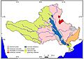
Generalized Geological Map of Godavari Drainage Basin

Read More
- Peninsular River System Of India
See also
 In Spanish: Río Godavari para niños
- Godavari Water Disputes Tribunal
- Detailed list of Tributaries
- Godavari River Basin Irrigation Projects
- Godavari Arch Bridge
- Godavari Bridge
- Old Godavari Bridge
- List of dams and reservoirs in India
- River basins in Madhya Pradesh
- Godavari Maha Pushkaram
