
Chuathbaluk, Alaska facts for kids
Quick facts for kids
Chuathbaluk
Curarpalek
|
|
|---|---|

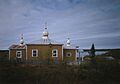
St. Sergius Chapel
|
|

Chuathbaluk, Alaska
Location in Alaska
|
|
| Country | United States |
| State | Alaska |
| Census area | Bethel |
| Incorporated | 1975 |
| Area | |
| • Total | 6.22 sq mi (16.12 km2) |
| • Land | 4.47 sq mi (11.58 km2) |
| • Water | 1.75 sq mi (4.54 km2) |
| Elevation | 154 ft (47 m) |
| Population
(2020)
|
|
| • Total | 104 |
| • Density | 23.27/sq mi (8.98/km2) |
| Time zone | UTC-9 (Alaska (AKST)) |
| • Summer (DST) | UTC-8 (AKDT) |
| ZIP code |
99557
|
| Area code | 907 |
| FIPS code | 02-14330 |
| GNIS feature ID | 1400376 |
Chuathbaluk (pronounced Choo-ath-bah-look) is a small city in Alaska, United States. Its name in the local Yup'ik language is Curarpalek. It is located in the Bethel Census Area.
In 2020, about 104 people lived in Chuathbaluk. This number was a bit lower than in 2010, when 118 people lived there.
Contents
Where is Chuathbaluk Located?
Chuathbaluk is found in a beautiful part of Alaska. It sits right on the Kuskokwim River. This river is very important for the people who live there.
The city is about 100 miles (160 kilometers) upstream from a larger town called Bethel. Just north of Chuathbaluk, you can see a small group of mountains called the Russian Mountains.
How Big is Chuathbaluk?
The city covers a total area of about 6.2 square miles (16.1 square kilometers). Most of this area is land, about 4.5 square miles (11.6 square kilometers). The rest is water, which includes parts of the Kuskokwim River.
Who Lives in Chuathbaluk?
The population of Chuathbaluk has changed over the years. Here's how many people have lived there during different census counts:
| Historical population | |||
|---|---|---|---|
| Census | Pop. | %± | |
| 1970 | 94 | — | |
| 1980 | 105 | 11.7% | |
| 1990 | 97 | −7.6% | |
| 2000 | 119 | 22.7% | |
| 2010 | 118 | −0.8% | |
| 2020 | 104 | −11.9% | |
| U.S. Decennial Census | |||
Chuathbaluk first appeared in the census in 1970. It officially became a city in 1975. Before that, it was sometimes called "Little Russian Mission." This name helped people tell it apart from another place called Russian Mission on the Yukon River.
Most people living in Chuathbaluk are Native American. In 2000, about 91.6% of the people were Native American. The average family size was about four people.
Age Groups in Chuathbaluk
In 2000, many young people lived in Chuathbaluk. About 43% of the population was under 18 years old. The average age of people in the city was 23 years.
What is the History of Chuathbaluk?
Chuathbaluk has a rich history, especially for the Deg Hit'an Athabascan people. They used to have summer camps in this area to catch fish.
The Russian Orthodox Church
In the late 1800s, the Russian Orthodox Church built a mission here called St. Sergius Mission. This was around 1894. People from a nearby village called Kukuktuk moved to live near the mission.
How the Name Changed
Over time, the village had several names, like Chukbak and Little Russian Mission. Because it was often confused with another Russian Mission on the Yukon River, the name was changed in the 1960s. The new name, Chuathbaluk, comes from a Yup'ik word, Curapalek. This word means "the hills where the big blueberries grow."
Challenges and Rebuilding
In 1900, many people in the village were lost due to a sickness. By 1929, the area was empty, but Russian Orthodox church members still held services at the mission.
In 1954, the family of Crow Village Sam Phillips moved back to the mission site. Later, other families from nearby towns joined them. The church was rebuilt in the late 1950s. A state school opened in the 1960s, which was important for the children. Finally, the community officially became a city in 1975.
Education in Chuathbaluk
Students in Chuathbaluk attend the Crow Village Sam School. This school is part of the Kuspuk School District. It teaches students from kindergarten all the way through 12th grade.
Images for kids
-
St. Sergius Chapel
See also

- In Spanish: Chuathbaluk para niños
