
Chumar facts for kids
Quick facts for kids
Chumar
ཆུ་མུར་
Chumur
|
|
|---|---|
|
Village
|
|

Chumar
Location in Ladakh

Chumar
Location in India
|
|
| Country | |
| Union Territory | Ladakh |
| District | Leh |
| Tehsil | Nyoma |
| Government | |
| • Type | Halqa Panchayat |
| Elevation | 5,100 m (16,700 ft) |
| Languages | |
| • Official | Ladakhi, Hindi |
| Time zone | UTC+5:30 (IST) |
Chumar or Chumur (Tibetan: ཆུ་མུར་, Wylie: chu mur) is a small village in south-eastern Ladakh, India. It is a key area for nomads who move their animals to different pastures. The village is located in the Rupshu region, south of the Tso Moriri lake. It sits on the bank of the Parang River (also called Pare Chu). Chumar is very close to Ladakh's border with Tibet. Since 2012, there has been a discussion about the border in this area, but the village of Chumar itself is not part of this dispute.
Contents
Where is Chumar?


Chumar is found along the Pare Chu river, near the border between Ladakh and Tibet. The Pare Chu river starts in Himachal Pradesh, India. It flows through Ladakh and then turns towards Tibet. After about 80 miles, the Pare Chu river flows back into Himachal Pradesh. There, it joins the Spiti River.
The village of Chumar is in a side valley of the Pare Chu. It is on the bank of a small stream called Chumur Tokpo. This stream flows down from a mountain known as Mount Shinowu. There is also an old Buddhist temple, called a gompa, near the village. Further upstream, you can find a Chumur monastery.
Pastures and Nomads
Along the Pare Chu river and its smaller streams, there are many grasslands. These are used as pastures by the nomadic people of Rupshu. Some of these important grazing areas include Sarlale, Takdible, Nirale, Tible, Lemarle, and Chepzile.
Chepzile is close to a small village called Chepzi. This hamlet even has some farmlands. Two smaller rivers join the Pare Chu near Chepzi. One is the Kyumsalung Panglung stream from the east. The other is the Chepzilung stream from the west. The Chepzilung stream starts below Mount Gya, which is an important point on the border between Spiti Valley and Tibet.
According to a map made by Frederic Drew in 1874, these two smaller rivers were considered border rivers of Ladakh. Drew noted that people from Jammu and Kashmir could graze their animals up to this boundary. People from Tibet did the same on their side of the border.
Border Discussions

After India became independent in 1947, some parts of the Chepzilung valley were given to Tibet. When India officially defined its borders in 1954, it also moved its boundary away from the Panglung river. The new border was set along a mountain ridge. On the Pare Chu river itself, India's border is about five miles south of Chumar. This allows Tibetan herders to use the rivers at Chepzi.
These decisions created a "bulge" in Indian territory near the Pare Chu river. The Indian government explained that people from Ladakh had always used these grazing lands near Chepzi. The people of Chumar say they continued to use the farmlands and grazing areas at Chepzi until recently. They claim that the People's Liberation Army has stopped them from reaching these lands. Even today, the local noble family of Rupshu owns farmland and a palace in Chepzi.
The Indian Army has sometimes said that the Chepzi grazing grounds are "beyond the Indian borders." However, local people believe the Army does not fully understand their traditional grazing routes.
China's Claims
In border talks with India in the 1960s, China claimed a border line north of India's claim. By 2012, China was claiming a border even further north. This created its own "bulge" of territory, as shown on some maps.
Border Interactions
Chumar is one of the most active areas along the Line of Actual Control (LAC). This is where Chinese and Indian troops often meet. Chumar was a difficult area for Chinese troops because, until 2014, they did not have roads close to the LAC there.
Experts say that China might want a straighter border in Chumar. This would remove the "bulge" in the LAC. Before 2012, this area was considered an international border, not a disputed line.
In 2013, during a border disagreement, India agreed to remove some military shelters in Chumar. In return, China pulled back its troops from another disputed area.
There is a road from Chumar that goes up to the LAC. Along this road, there is an Indian military post called Point 30R. It is named 30R because it is on a sharp rise of 30 meters. Chinese patrols often come to 30R. However, their vehicles cannot reach this point. They have even tried using horses to get there.
The Chinese have tried to build a road across 30R. In 2014, they claimed they had orders to build a road to Tible. But India has stopped them from doing this. During a standoff in 2014, Chinese troops were on 30R with heavy machinery for road building. There were also reports that Chinese troops removed Indian surveillance cameras from the area. This face-off in 2014 started just before the Chinese leader visited India and continued during his visit. Indian media reported that nearly 1000 Chinese soldiers entered Indian territory in the Chumar area during this time.
How to Get There
Chumar is connected by roads to several other places. These include:
- Rayul Lake, about 50 km north.
- Hanle, about 100 km east.
- Tso Moriri, about 60 km north.
- Meroo on NH-3, about 225 km north.
In 2020, a new road project was approved. This road will be about 150 km long. It will link Chumar in Ladakh to Pooh in Himachal Pradesh.
Images for kids
-
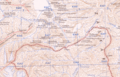
Map 1: The border near Chumar in 1954
-
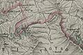
Map 2: Geologist Frederic Drew's map from 1874
-
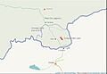
Map 3: Border lines claimed by China and India in 2012
