
Chumphon Province facts for kids
Quick facts for kids
Chumphon
ชุมพร
|
|||
|---|---|---|---|

Mu Ko Chumphon National Park
|
|||
|
|||
| Motto(s):
"ประตูภาคใต้ ไหว้เสด็จในกรมฯ ชมไร่กาแฟ แลหาดทรายรี ดีกล้วยเล็บมือ ขึ้นชื่อรังนก" ("Southern door, Worshiping in (Chumphon Khet Udomsak),See coffee plantations, See Sairee beach, Banana fingernail and Famous for bird's nest")
|
|||

Map of Thailand highlighting Chumphon province
|
|||
| Country | Thailand | ||
| Capital | Chumphon | ||
| Area | |||
| • Total | 6,009 km2 (2,320 sq mi) | ||
| Area rank | Ranked 37th | ||
| Population
(2018)
|
|||
| • Total | 510,963 | ||
| • Rank | Ranked 54th | ||
| • Density | 85/km2 (220/sq mi) | ||
| • Density rank | Ranked 56th | ||
| Human Achievement Index | |||
| • HAI (2017) | 0.6252 "high" Ranked 15th |
||
| Time zone | UTC+7 (ICT) | ||
| Postal code |
86xxx
|
||
| Calling code | 077 | ||
| ISO 3166 code | TH-86 | ||


Chumphon (Thai: ชุมพร) is a beautiful province in southern Thailand. It's located right on the Gulf of Thailand. This province is often called the "Gateway to the South" because it connects central Thailand to the southern parts of the country and the Malay Peninsula.
Chumphon shares its borders with other Thai provinces like Prachuap Khiri Khan, Surat Thani, and Ranong. To its west, it also touches the country of Burma (Myanmar).
Contents
Geography of Chumphon
Chumphon is special because it sits on the Isthmus of Kra. This is a very narrow strip of land that connects the big mainland of Thailand to the long, thin Malay Peninsula.
On the western side of Chumphon, you'll find hills that are part of the Phuket mountain range. To the east, there's a flat coastal area next to the Gulf of Thailand. The main river flowing through the province is the Lang Suan River.
Chumphon has a long coastline, stretching about 222 kilometers (138 miles). It also has 44 islands! This means you can find many different natural sights here, like waterfalls, calm beaches, green forests, mangrove swamps, and rivers. About 21.5% of the province is covered by forests.
National Parks
Chumphon is home to two important national parks. These parks help protect the natural beauty and wildlife of the area:
- Namtok Ngao National Park
- Mu Ko Chumphon National Park
Wildlife Sanctuaries
There are also four special wildlife sanctuaries in Chumphon. These places are set aside to protect animals and their natural homes:
- Khuan Mae Yai Mon Wildlife Sanctuary
- Thung Raya–Na Sak Wildlife Sanctuary
- Prince Chumphon South Park Wildlife Sanctuary
- Prince Chumphon North Park (lower) Wildlife Sanctuary
History of Chumphon
The southern part of Chumphon province used to be a separate province called Lang Suan. But in 1932, it became part of Chumphon.
In November 1989, a very strong storm called Typhoon Gay hit Chumphon. It caused a lot of damage and affected many people. It was the only typhoon ever recorded to reach Thailand with such strong winds.
What's in a Name?
There are two interesting ideas about how Chumphon got its name:
- One idea is that it comes from Chumnumphon, which means 'gathering of forces'. This makes sense because Chumphon was a frontier city where soldiers would gather before battles.
- Another idea is that the name comes from a local tree called Maduea Chumphon (มะเดื่อชุมพร), which is a type of fig tree. These trees were very common in the province.
Symbols of Chumphon
Every province has special symbols!
- The provincial seal of Chumphon shows a special angel-like figure called a thevada sitting on a lotus flower. On either side of the angel are two fig trees. In the background, you can see a fort and two watchtowers. This reminds everyone that Chumphon was a place where brave warriors gathered to fight for their land.
- The provincial flower is the Indian shot (Canna indica).
- The finger banana is another important symbol of the province.
- The provincial fish is the Spanner barb (Barbodes lateristriga).
How Chumphon is Governed

Chumphon province is divided into eight main areas called districts (amphoes). These districts are further split into 70 sub-districts (tambons), and then into 736 villages (mubans).
Here are the eight districts:
- Mueang Chumphon
- Tha Sae
- Pathio
- Lang Suan
- Lamae
- Phato
- Sawi
- Thung Tako
The province has a main administration organization. There are also 27 municipal areas. The cities of Chumphon and Lang Suan have "town" status. Other smaller areas are managed by subdistrict municipalities or administrative organizations.
Chumphon's Economy
Chumphon is known for its important crops.
- The Ban Panwal valley in Tha Sae District is famous for coffee farms. It produces a huge amount of robusta coffee every year. In fact, Chumphon province grows about 60% of all the coffee in Thailand! Some local coffee brands are Thamsing and Khao Tha-Lu Chumporn.
- Chumphon is also the second-largest durian growing area in Thailand. Durian is a popular fruit, and in 2017, Chumphon had a large area dedicated to growing it, bringing in a lot of money for the province. More farmers are choosing to grow durian each year.
Getting Around Chumphon
It's easy to travel to and within Chumphon!
By Air
Chumphon Airport is about 30 kilometers (19 miles) north of Chumphon city. You can fly directly to Chumphon from Bangkok's Don Mueang Airport (DMK). The flight takes about an hour. Airlines like Nok Air and Thai AirAsia offer these flights. The airport also helps travelers connect to popular islands in the Gulf of Thailand like Ko Tao, Ko Pha Ngan, and Ko Samui.
By Rail

Chumphon Railway Station is the main train station in the province. It's about 485 kilometers (301 miles) south of Bangkok Railway Station. Chumphon has 26 other smaller railway stations and stops. The Lang Suan Railway Station is the last stop on the Southern Railway that starts from Thon Buri Railway Station in Bangkok.
By Road
Chumphon is about 463 kilometers (288 miles) south of Bangkok by road. You can take Petchkasem Road (Thailand Route 4) to get there. The drive usually takes about 7 hours. You can also travel to Chumphon by bus from Bangkok's Southern Bus Terminal or Northern Bus Terminal.
Tourism in Chumphon
Chumphon is becoming more and more popular with tourists! In 2015, the number of visitors grew a lot, and tourism brought in a lot of money for the province.
Beautiful Beaches
Chumphon has a long coastline with many lovely beaches.
- Hat Thung Wua Laen: This beach is about 16 kilometers (10 miles) northeast of downtown Chumphon. It's a great place to find food and places to stay. It's also close to the train station and the airport.
- Hat Saphli: Just about 2 kilometers (1.2 miles) from Hat Thung Wua Laen, this beach has a pretty crescent shape and white sand. It was even named the cleanest beach in Thailand in 2017! Nearby, there's a fishing village called Ban Tha Samet that's famous for making shrimp paste and fish sauce.

- Hat Sai Ri: This beach has soft white sand and clear water. It's also a very special place because it's home to a shrine for Prince Abhakara Kiartivongse, who is known as the "Father of the Royal Thai Navy." Close by, you can see the HTMS Chumphon, which is a real torpedo boat!
Notable People
- Baitong Jareerat Petsom (born 1993) - She is an environmental advocate, writer, host, director, and even won the title of Miss Earth - Fire 2021 in a beauty pageant!
Images for kids
-
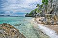
Ko Rangkachio, Mu Ko Chumphon National Park
-
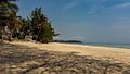
Thung Wua Laen Beach
-
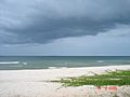
Another corner of Thung Wua Laen Beach
-
Prince of Chumphon Shrine at Hat Sai Ri
-
Thai nameplate of Hat Sai Ri, it states that "once upon a time at Hat Sai Ri, Chumphon"
-
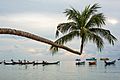
The Extraordinary Coconut Tree in Ko Tao


_-_panoramio.jpg)
.jpg)
.jpg)

See also
 In Spanish: Provincia de Chumphon para niños
