Claremont Canyon Regional Preserve facts for kids
Quick facts for kids Claremont Canyon Regional Preserve |
|
|---|---|

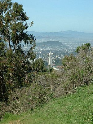
View from Claremont Canyon Regional Preserve. March 13, 2004. The University of California, Berkeley's Sather Tower is in the near view. Behind that is Albany Hill, and the large mountains in the background are the Marin Hills.
|
|
| Lua error in Module:Location_map at line 420: attempt to index field 'wikibase' (a nil value). | |
| Type | Regional park |
| Location | Oakland, California |
| Area | 205 acres (83 ha) |
| Created | 1978 |
| Operated by | East Bay Regional Parks District |
| Status | Open |
Claremont Canyon Regional Preserve is a cool nature park in Oakland, California. It's managed by the East Bay Regional Park District. The park gets its name from Claremont Canyon, where Claremont Creek flows. This creek eventually joins Temescal Creek. Long ago, this area was called "Harwood's Canyon," then "Telegraph Canyon." A developer later changed the name to Claremont, like the nearby Claremont neighborhood.
Contents
Discovering Claremont Canyon's Past
This land, now known as Claremont Canyon, has a long history. In 1820, it was part of a Spanish land grant called Rancho San Antonio. Later, it became an important path for American settlers moving to California. In 1858, a telegraph line was built through the canyon. This line helped send messages across the country. From the 1860s, the famous "Pony Express" also carried mail through this canyon.
The East Bay Regional Park District (EBRPD) started buying parts of this land in 1978. First, they bought 80 acres (32 ha) near the U.C. Berkeley campus. Then, they added more land from different owners. Finally, they bought another 64 acres (26 ha) in Gwin Canyon. All these pieces together became the Claremont Canyon Regional Preserve.
Exploring the Park's Landscape
Even though it's only 205 acres (83 ha), Claremont Canyon Regional Preserve is a key part of the parks along the Berkeley Hills. The park starts at about 420 feet (130 m) above sea level. This is right behind the Clark Kerr campus of the University of California, Berkeley. It then rises to an average of 1300 feet (400 m) at the ridge of the East Bay hills.
The preserve connects to other parks like Tilden Regional Park and Sibley Volcanic Regional Preserve. It links up through land owned by the University and the East Bay Municipal Utility District. This means you can walk directly from the cities of Berkeley and Oakland into this park system. You can even get there using public transportation!
Fun Activities at the Preserve
Claremont Canyon Regional Preserve is mostly natural and doesn't have many fancy facilities. But it offers two great hiking trails for visitors: the Stonewall Panoramic Trail and the Gwin Canyon Trail.
Hiking the Stonewall Panoramic Trail
The Stonewall Panoramic Trail begins at a parking spot on Stonewall Road. This is located behind the old Claremont Hotel. The trail is 1.6 miles (2.6 km) long. It climbs about 700 feet (210 m) up the hill.
This steep path leads to amazing views from the ridge. You can see across the cities of Berkeley and Oakland. Beyond that, you'll spot the San Francisco Bay, the famous Golden Gate Bridge, and the city of San Francisco. On clear days, especially in winter, you might even see the Farallon Islands. These islands are about 44 miles (70 km) away!
Walking the Gwin Canyon Trail
Inside the preserve, there's a smaller canyon called Gwin Canyon. It has a 2-mile (3.2 km) trail. You can reach this trail from the end of Norfolk Road, near Strathmoor Drive in the Oakland Hills. The trail ends just above Claremont Creek. This is about 0.6 miles (0.97 km) from where you start.
Even though they are not part of the preserve, the University of California owns and manages an extra 225 acres (0.91 km2) of open space next to it. A local group called the Claremont Canyon Conservancy also helps. They work with landowners to care for the area and offer educational programs.
Getting to the Preserve
There isn't much public parking right at or near the preserve. Parking on the street is not allowed. Visitors are encouraged to use public transportation to get to the UC Berkeley campus. From there, you can hike into the preserve.
 | Aurelia Browder |
 | Nannie Helen Burroughs |
 | Michelle Alexander |

