Clarence Island (South Shetland Islands) facts for kids

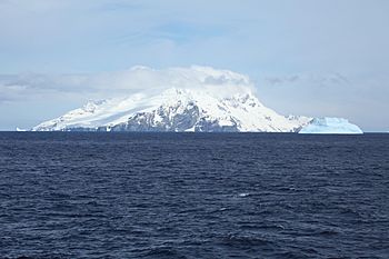
Clarence Island seen from the north, with Cape Lloyd and Jubilee Peak in the foreground
|
|

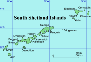
Location of Clarence Island
|
|
| Geography | |
|---|---|
| Location | Antarctica |
| Coordinates | 61°12′S 054°05′W / 61.200°S 54.083°W |
| Archipelago | South Shetland Islands |
| Length | 21.46 km (13.335 mi) |
| Highest elevation | 1,950 m (6,400 ft) |
| Highest point | Mount Irving |
| Administration | |
| Administered under the Antarctic Treaty System | |
| Demographics | |
| Population | 0 |
Clarence Island is the island furthest to the east in the South Shetland Islands. These islands are found off the coast of Antarctica. The island is claimed by three different countries. These are Argentina, Britain, and Chile. However, the island is managed under an international agreement. The name Clarence Island has been used for a very long time, since at least 1821.
Contents
About Clarence Island
Where is Clarence Island?
Clarence Island is part of the South Shetland Islands. These islands are located in the Southern Ocean, near the continent of Antarctica. It is the easternmost island in this group.
What Does Clarence Island Look Like?
Clarence Island is about 21.46 km (13.3 mi) long. It stretches from the south-southwest to the north-northeast. The inside of the island is very mountainous. It has two main ridges called Ravelin Ridge and Urda Ridge.
The highest point on the island is Mount Irving. This mountain is 1,950 meters (6,398 ft) tall. It stands about 6.675 km (4.148 mi) north of Cape Bowles. Cape Bowles is the southernmost tip of the island.
Glaciers and Coves
Many glaciers flow down the slopes of Clarence Island. On the southeast side, you'll find Dobrodan, Highton, Treskavets, Orcho, and Banari Glacier. On the northwest side, there are Skaplizo, Giridava, and Bersame Glacier.
There are also small islands near Clarence Island. One of these is Sugarloaf Island, located just to the east. The island also has several coves, which are small, sheltered bays. Chinstrap Cove is on the northwest coast. Istros Bay, Smith Cove, and Kutela Cove are on the southeast side.
Who Claims Clarence Island?
Even though Clarence Island is in Antarctica, three countries claim it as their territory. These are Argentina, Britain, and Chile. However, because of the Antarctic Treaty System, no single country fully owns it. This treaty helps make sure Antarctica is used for peaceful scientific research.
History of Exploration
Clarence Island has been part of some important explorations.
Ernest Shackleton's Expedition
The famous Antarctic explorer Ernest Shackleton saw Clarence Island during his Imperial Trans-Antarctic Expedition. This was after his ship was crushed by ice in the Weddell Sea. His crew considered landing on Clarence Island. However, they decided to land on nearby Elephant Island instead.
Later Expeditions
In 1970, a group called the Joint Services Elephant Island Expedition reached the highest point on Clarence Island. This expedition also mapped out both Elephant Island and Clarence Island.
Maps
See also
 In Spanish: Isla Clarence (Antártida) para niños
 | Frances Mary Albrier |
 | Whitney Young |
 | Muhammad Ali |


