
Clayton, Michigan facts for kids
Quick facts for kids
Clayton, Michigan
|
|
|---|---|
|
Village
|
|
| Village of Clayton | |

Facing north along State Street
|
|

Location within Lenawee County
|
|

Clayton, Michigan
Location in Michigan

Clayton, Michigan
Location in the United States
|
|
| Country | United States |
| State | Michigan |
| County | Lenawee |
| Townships | Dover and Hudson |
| Established | 1836 |
| Platted | 1843 |
| Incorporated | 1870 |
| Government | |
| • Type | Village council |
| Area | |
| • Total | 0.71 sq mi (1.84 km2) |
| • Land | 0.71 sq mi (1.84 km2) |
| • Water | 0.00 sq mi (0.00 km2) |
| Elevation | 896 ft (273 m) |
| Population
(2020)
|
|
| • Total | 311 |
| • Density | 436.80/sq mi (168.77/km2) |
| Time zone | UTC-5 (Eastern (EST)) |
| • Summer (DST) | UTC-4 (EDT) |
| ZIP code(s) |
49235
|
| Area code(s) | 517 |
| FIPS code | 26-16280 |
| GNIS feature ID | 0623395 |
Clayton is a small village located in Lenawee County, in the U.S. state of Michigan. In 2020, about 311 people lived there. The village is partly in Hudson Township and partly in Dover Township.
Contents
History of Clayton
The area where Clayton is now was first settled in 1836. It was originally called East Dover because it was in the eastern part of Dover Township. A post office opened in East Dover on March 8, 1837.
In 1843, a man named Rueben Bird planned out the community. He later had the post office name changed to Clayton on July 17, 1849. He named it after his friend, Reverend Clayton, who was from New York. Clayton officially became a village in 1870.
Geography of Clayton
According to the U.S. Census Bureau, the village covers a total area of about 0.71 square miles (1.84 square kilometers). All of this area is land.
Main Roads in Clayton
- M-34 (also known as West Carleton Road) runs east to west near the southern edge of the village.
- M-156 (Morey Highway) ends where it meets M-34.
Population and People
| Historical population | |||
|---|---|---|---|
| Census | Pop. | %± | |
| 1880 | 368 | — | |
| 1900 | 370 | — | |
| 1910 | 372 | 0.5% | |
| 1920 | 306 | −17.7% | |
| 1930 | 372 | 21.6% | |
| 1940 | 375 | 0.8% | |
| 1950 | 467 | 24.5% | |
| 1960 | 470 | 0.6% | |
| 1970 | 505 | 7.4% | |
| 1980 | 396 | −21.6% | |
| 1990 | 384 | −3.0% | |
| 2000 | 326 | −15.1% | |
| 2010 | 344 | 5.5% | |
| 2020 | 311 | −9.6% | |
| U.S. Decennial Census | |||
Clayton's Population in 2010
In 2010, there were 344 people living in Clayton. Most of the people (93.6%) were White. About 5.5% of the population identified as Hispanic or Latino.
The average age of people in the village was 31.5 years old. About 30.5% of the residents were under 18 years old.
Education
Students living in Clayton attend schools that are part of the Hudson Area Schools district. These schools are located to the west in the city of Hudson.
Images for kids
-
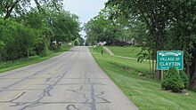
Signage along Morey Highway -
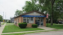
U.S. Post Office in Clayton -
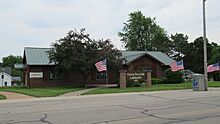
Clayton Town Hall and Library


See also
 In Spanish: Clayton (Míchigan) para niños
