Clover Creek, Virginia facts for kids
Quick facts for kids
Clover Creek, Virginia
|
|
|---|---|

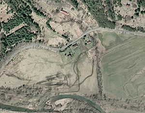
Aerial view of Clover Creek, Virginia
|
|
| Country | United States |
| State | Virginia |
| County | Highland |
| Elevation | 1,870 ft (570 m) |
| Time zone | UTC-5 (Eastern (EST)) |
| • Summer (DST) | UTC-4 (EDT) |
| ZIP code |
24458
|
| Area code(s) | 540 |
| GNIS feature ID | 1495400 |
Clover Creek is a small, quiet community in Highland County, Virginia, in the United States. It's not a city or town with its own government, but rather an "unincorporated community." You can find it about 10 miles (16 km) south of Monterey, Virginia, along State Route 678. The community sits in the beautiful Bullpasture Valley, right by the Bullpasture River.
Contents
What's in a Name?
Clover Creek has had a few different names over the years. It was once known as "McClungs Mill." For a while, it was officially called "Clovercreek" (one word). This name was decided by the United States Board on Geographic Names in 1897. However, in 1970, the board changed it to the two-word "Clover Creek" that we use today.
A Glimpse into History
Clover Creek has an interesting past, especially during the French and Indian War.
Fort George: A Frontier Outpost
In 1754, during the French and Indian War, a British fort called Fort George was built near Clover Creek. This fort was made of wood and was about 90 feet (27 meters) square. It was built to protect the area.
Was Fort George Ever Attacked?
Even though it was a fort, Fort George was never directly attacked by enemy forces. At one point, arrows were shot at the fort from a distance. Luckily, they didn't cause any damage.
George Washington's Visit
It's believed that George Washington, who would later become the first President of the United States, might have visited Fort George. He was traveling in the area at the time. If he did visit, it would be the only time Washington ever came to the region now known as Highland County.
Historic Places
The McClung Farm Historic District is an important part of Clover Creek's history. This district, which includes the Clover Creek Presbyterian Church, is listed on the National Register of Historic Places. This means it's recognized for its historical importance and is protected.
 | Madam C. J. Walker |
 | Janet Emerson Bashen |
 | Annie Turnbo Malone |
 | Maggie L. Walker |


