Clyde Walkway facts for kids
Quick facts for kids Clyde walkway |
|
|---|---|

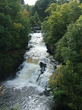
Corra Linn above New Lanark
|
|
| Length | 65 km (40 mi) |
| Location | Central Scotland |
| Established | 2005 |
| Designation | Scotland's Great Trails |
| Trailheads | Partick station, Glasgow 55°52′12″N 4°18′32″W / 55.870°N 4.309°W Bonnington Linn, New Lanark 55°38′49″N 3°46′12″W / 55.647°N 3.77°W |
| Use | Hiking |
| Elevation gain/loss | 720 metres (2,360 ft) gain |
| Sights | River Clyde |
The Clyde Walkway is a special path in Scotland. It's great for walking and mountain biking. This path goes from Glasgow all the way to a famous place called New Lanark. New Lanark is a UNESCO World Heritage Site.
The path follows the River Clyde for most of its journey. It was finished in 2005. Now, it's one of Scotland's Great Trails. These are long-distance paths that are well-known. The whole path is about 65 kilometres (40 miles) long.
It mixes city walking through Glasgow with beautiful countryside. You'll see the Clyde Valley Woodlands National Nature Reserve. You can also visit the amazing Falls of Clyde. About 155,000 people use this path each year. Some even walk the whole route over a few days!
Contents
Exploring the Clyde Walkway
The Clyde Walkway is divided into different sections. Each part offers something new to see. Let's explore them!
From Glasgow to Cambuslang Bridge
This first part of the path is about 15 kilometres (9 miles) long. It starts at Partick station in Glasgow. From there, it follows the north side of the River Clyde. The path ends near Cambuslang Bridge.
This section connects to other long-distance paths. These include the Glasgow to Inverness National Cycle Route. You can also link up with the Kelvin Walkway. There are also paths leading to Edinburgh and Greenock. Along the way, you'll pass many interesting places.
From Cambuslang Bridge to Strathclyde Country Park
This section is about 14 kilometres (9 miles) long. It stays very close to the River Clyde. As you walk, you'll pass some cool historic spots.
You can see Bothwell Castle, which is a very old building. You'll also go by the David Livingstone Centre. This place celebrates a famous Scottish explorer. The path ends at the Watersports Centre in Strathclyde Country Park. This park is a fun place for outdoor activities.
From Strathclyde Country Park to Cardies Bridge
This part of the walkway is also about 14 kilometres (9 miles) long. It mostly follows the north side of the River Clyde. This section takes you through open countryside. It's a great place to enjoy nature.
You can also find the Avon Walkway here. This path can take you to Chatelherault Country Park. The section finishes at Cardies Bridge.
From Cardies Bridge to Crossford
This part of the path is about 10 kilometres (6 miles) long. It goes through very pretty countryside. This area of the Clyde Valley was once famous for its fruit orchards. It also had many greenhouses. Some of these old orchards are still there today.
You'll also pass Craignethan Castle. This castle was built in the 1500s and is very well preserved. The path ends at the village of Crossford. From here, you can catch a bus to nearby towns.
From Crossford to New Lanark
This last section is about 11 kilometres (7 miles) long. Many people think it's the most beautiful part of the path. It continues through open country along the River Clyde.
First, you'll see the Stonybyres Hydroelectric Station. This power station was built in 1927. The waterfalls here are 21 metres (69 feet) high! Fish like salmon can't swim past them.
After passing the town of Lanark, you'll enter New Lanark. This village is a UNESCO World Heritage site. It was built in the 1700s. People used the power of the River Clyde to run cotton mills. Now, it's a restored village where you can learn about history.
Beyond New Lanark, the path enters the Falls of Clyde Nature Reserve. You'll pass another power station, Bonnington Hydroelectric Station. Then, you'll see the three remaining Falls of Clyde. The most amazing one is Corra Linn. It's a huge waterfall, 28 metres (92 feet) high!
The Clyde Walkway finishes in the countryside at the top waterfall, Bonnington Linn. There's a dam here that sends water to the power station.
 | Calvin Brent |
 | Walter T. Bailey |
 | Martha Cassell Thompson |
 | Alberta Jeannette Cassell |

