Coal Road facts for kids
Quick facts for kids Coal Road |
|
|---|---|
| Lua error in Module:Infobox_road/map at line 15: attempt to index field 'wikibase' (a nil value). | |

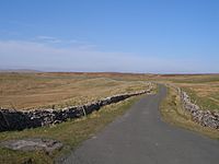
The Coal Road, looking north
|
|
| Route information | |
| Length | 4 mi (6 km) |
| Existed | 12th century–present |
| Major junctions | |
| North end | Garsdale |
| South end | Dent |
| Location | |
| Counties: | Cumbria, |
| Highway system | |
| Template:Infobox road/browselinks/ENG | |
The Coal Road is a historic path in Cumbria, England. It's also known as the Galloway Gate Road. This road connects the railway stations at Garsdale and Dent. It runs through the beautiful Yorkshire Dales National Park. Long ago, it was part of the West Riding of Yorkshire. The road got its name because people used it to carry coal from local mines. Even before that, it was a special path for moving animals between England and Scotland.
Contents
What is the Coal Road?
The Coal Road is an old path that links Garsdale and Dentdale. It goes along the western side of Great Knoutberry Hill. At its highest point, the road reaches about 1,755 feet (535 meters) above sea level. Because it's so high up, the road often gets blocked by snow in winter.
Why is it Called the Coal Road?
The name "Coal Road" comes from the many coal mines that used to be near the road. These mines were on the northern slopes of Great Knoutberry. People first got permission to dig for coal here in 1742. Miners used the Coal Road to carry their coal on horses. They took it to places like Dentdale, Garsdale, Sedbergh, and even as far as Kendal. This continued until the Settle Carlisle Railway was built. The railway made it easier to bring in better coal from other places.
At its busiest, there were about twenty coal mines on Great Knoutberry. Most of these were shallow pits, easy to dig from the ground. The coal layer was only about 7 inches (18 cm) thick. But it was very useful for whitesmiths (metalworkers) in the valley. The biggest mine, Cross Pits Colliery, was about 1,800 feet (550 meters) above sea level. Miners mostly dug the coal by hand, using a simple winch called a "jack roller."
The Old Drovers' Route
Maps also show this path was called the Galloway Gate Road. The Galloway Gate was part of an old route used by "drovers." Drovers were people who moved large groups of farm animals, like cattle, from one place to another. This route went between England and Scotland through Mallerstang. The part of the Coal Road from Lea Yeat in Cowgill to Garsdale railway station is 4 miles (6.4 km) long. It was paved with tarmac in 1954.
The name Galwaithegate was mentioned in a document from the 12th century. It described a road between Tebay and Kirkby Lonsdale where cattle were moved. It's believed that the Scottish Galloway cattle might have given the road its name.
A Challenge for Cyclists
The Coal Road is very famous among cyclists. This is because of its steep climb from Dentdale towards Garsdale Head. The paved road "goes up and down like a fairground ride," making it an exciting challenge. The road is part of a big cycling event called the Etape du Dales, which happens every May. A section of the road is also part of the Pennine Bridleway, a long trail for horse riders, cyclists, and walkers.

