Colchester (CDP), Connecticut facts for kids
Quick facts for kids
Colchester, Connecticut
|
|
|---|---|

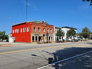
Main Street
|
|
| Country | |
| State | Connecticut |
| County | New London |
| Town | Colchester |
| Area | |
| • Total | 11.58 km2 (4.47 sq mi) |
| • Land | 11.58 km2 (4.47 sq mi) |
| • Water | 0.0 km2 (0 sq mi) |
| Elevation | 141 m (463 ft) |
| Population
(2010)
|
|
| • Total | 4,781 |
| • Density | 413.0/km2 (1,070/sq mi) |
| Time zone | UTC-5 (Eastern (EST)) |
| • Summer (DST) | UTC-4 (EDT) |
| ZIP Code |
06415
|
| Area code(s) | 860/959 |
| FIPS code | 09-15840 |
| GNIS feature ID | 2378348 |
Colchester is a special kind of community called a census-designated place (CDP). This means it's an area that the U.S. Census Bureau defines for gathering population data. It includes the main village and nearby homes within the larger town of Colchester.
Colchester is located in New London County, Connecticut, in the United States. A major road, Connecticut Route 2, runs through the southern part of the community. In 2010, the CDP had a population of 4,781 people. The entire town of Colchester had a population of 16,068 at that time.
Colchester Village Historic District
The very center of Colchester village is a special area known as the Colchester Village Historic District. This district covers about 75 acres (30 hectares). It was officially recognized and added to the National Register of Historic Places in 1994. This means it's an important place with historical buildings and features that are protected.
See also
 In Spanish: Colchester (condado de New London) para niños
 | Selma Burke |
 | Pauline Powell Burns |
 | Frederick J. Brown |
 | Robert Blackburn |


