Colesville, New York facts for kids
Quick facts for kids
Colesville, New York
|
|
|---|---|

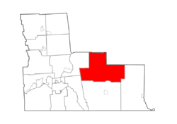
Map highlighting Colesville's location within Broome County.
|
|
| Country | United States |
| State | New York |
| County | Broome |
| Government | |
| • Type | Town Council |
| Area | |
| • Total | 79.17 sq mi (205.05 km2) |
| • Land | 78.36 sq mi (202.94 km2) |
| • Water | 0.81 sq mi (2.11 km2) |
| Elevation | 1,348 ft (411 m) |
| Population
(2020)
|
|
| • Total | 4,877 |
| • Estimate
(2021)
|
4,832 |
| • Density | 64.99/sq mi (25.09/km2) |
| Time zone | UTC-5 (Eastern (EST)) |
| • Summer (DST) | UTC-4 (EDT) |
| ZIP code |
13787
|
| Area code(s) | 607 |
| FIPS code | 36-007-17046 |
| GNIS feature ID | 0978851 |
Colesville is a small town located in Broome County, New York, in the United States. In 2020, about 4,877 people lived there.
The town is in the northeastern part of Broome County. It is also northeast of a larger city called Binghamton.
Contents
A Look at Colesville's History
The Colesville area was first settled around 1785. The town itself was officially created in 1821. It was formed from a part of the nearby town of Windsor.
How Colesville Got Its Name
A man named Robert Harpur was an important early developer in the area. He is believed to have given many places in central New York their names, including the community of Harpursville.
The Town Seal
The official seal for the town of Colesville was adopted in 2021.
Exploring Colesville's Geography
Colesville covers a total area of about 205 square kilometers (79 square miles). Most of this area is land, with a small part being water.
Location and Natural Features
The northern border of Colesville touches Chenango County. The Susquehanna River flows through the town, heading south.
Roads and Travel
Several important roads pass through Colesville:
- Interstate 88 is a major highway that crosses the town.
- New York State Route 7 and New York State Route 79 are other key highways.
- New York State Route 235 connects NY Route 7 north of Harpursville to State Route 206 in Coventry.
People of Colesville
Colesville has seen its population change over the years. Here's how the number of people living in Colesville has grown and changed:
| Historical population | |||
|---|---|---|---|
| Census | Pop. | %± | |
| 1830 | 2,389 | — | |
| 1840 | 2,528 | 5.8% | |
| 1850 | 3,061 | 21.1% | |
| 1860 | 3,250 | 6.2% | |
| 1870 | 2,460 | −24.3% | |
| 1880 | 3,208 | 30.4% | |
| 1890 | 3,126 | −2.6% | |
| 1900 | 2,773 | −11.3% | |
| 1910 | 2,415 | −12.9% | |
| 1920 | 2,311 | −4.3% | |
| 1930 | 2,394 | 3.6% | |
| 1940 | 2,652 | 10.8% | |
| 1950 | 3,084 | 16.3% | |
| 1960 | 3,773 | 22.3% | |
| 1970 | 4,420 | 17.1% | |
| 1980 | 4,965 | 12.3% | |
| 1990 | 5,590 | 12.6% | |
| 2000 | 5,441 | −2.7% | |
| 2010 | 5,232 | −3.8% | |
| 2020 | 4,877 | −6.8% | |
| 2021 (est.) | 4,832 | −7.6% | |
| U.S. Decennial Census | |||
In 2000, there were 5,441 people living in Colesville. About 36% of the households had children under 18. The average age of people in the town was 37 years old.
Most people in Colesville are White (about 97.85%). There are also smaller groups of African American, Native American, and Asian residents. About 0.74% of the population identified as Hispanic or Latino.
Communities and Places in Colesville
Colesville is made up of several smaller communities and interesting spots:
- Belden – A small village located northwest of Harpursville on NY Route 7.
- Center Village – Another small village, found south of Harpursville on NY Route 79.
- Doraville – A village in the eastern part of the town.
- Harpursville – This is the main community in Colesville. It's on NY-79 and has an exit from Interstate 88 (exit 6). The Harpursville United Methodist Church is an important historical building here.
- Nathaniel Cole Park Pond – A lake near West Colesville, great for outdoor activities.
- New Ohio – A village in the northwestern part of the town.
- Nineveh – A village northeast of Harpursville, right on the northern border of the town.
- North Colesville – A village in the northwestern part of the town, also on NY-79.
- Ouaquaga – A village located in the southern part of the town.
- Sanitaria Springs – A village at the western edge of the town. It can be reached from Interstate 88 (exit 4). It used to be called "Osborne Hollow."
- Tunnel – A location south of New Ohio.
- West Colesville – A village on the southern border of the town.
See also
 In Spanish: Colesville (Nueva York) para niños
 | Frances Mary Albrier |
 | Whitney Young |
 | Muhammad Ali |


