
College Hill, Wichita, Kansas facts for kids
Quick facts for kids
College Hill
|
|
|---|---|

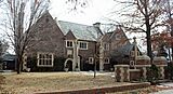
The Aviary, 330 Circle Drive
|
|
| Country | United States |
| State | Kansas |
| County | Sedgwick |
| City | Wichita |
| Elevation | 1,360 ft (410 m) |
| Population
(2016)
|
|
| • Total | 4,893 |
| ZIP code |
67208, 67211, 67214, 67218
|
| Area code | 316 |
College Hill is a historic neighborhood in Wichita, Kansas. It is mostly a place where people live. This area is known for its beautiful old homes and friendly community feel.
Contents
History of College Hill
College Hill started as a series of building projects in the 1880s. This was a time when many people were buying and selling land quickly. The neighborhood got its name from a college that was supposed to be built there. A Methodist church planned to build a college at Douglas and Rutan. However, they decided to build it in Winfield, Kansas instead. That college is now known as Southwestern College.
Most of the houses in College Hill were built between 1900 and 1934. In 1926, a new area called Lincoln Heights Addition opened up. It had 73 acres and 250 lots for new homes. Later, the Lincoln Heights Shopping Center was built. Construction started in June 1948 and finished in July 1949.
Where is College Hill Located?
College Hill is located in Wichita, Kansas. It sits at an elevation of 1,360 feet (410 meters) above sea level. The neighborhood is bordered by Central Avenue to the north and U.S. Route 54 to the south. Hillside Street is to the west, and Oliver Avenue is to the east.
College Hill is about 2.5 miles (4 km) east of Downtown Wichita. It is next to several other neighborhoods. These include Sleepy Hollow and Country Overlook to the north. Crown Heights North and Crown Heights South are to the east. Fairfax and Longview are to the south. Finally, East Front and Uptown are to the west.
College Hill Park: A Community Gem

College Hill Park is a large green space in the neighborhood. The Wichita Department of Park and Recreation takes care of it. This city park covers 22 acres (9 hectares). You can find it on English and Circle Drive, just south of Douglas Avenue.
The park has many fun things to do. It includes a basketball court, a playground, and shuffleboard courts. There is also a swimming pool and tennis courts. It's a great place for families to relax and play.
The Park's Interesting Past
Back in the 1880s, Wichita was growing very fast. It was even called the "Peerless Princess of the Plains." During this time, streetcars pulled by mules traveled along Douglas Avenue. They took people to work and to go shopping.
A college was originally planned for the area where the park is now. But those plans changed. From 1901 to 1912, the area was actually the Wichita Country Club. It had a golf course. Later, during the Great Depression, the park was redeveloped. Funds from the WPA helped turn the overgrown golf course into the park we see today. This included building the swimming pool.
Today, College Hill Park is a beloved spot. It's a wonderful place for families to walk, play, and enjoy nature.

Education in College Hill
Students in College Hill have several school options. Wichita Public Schools runs one school right in the neighborhood. This is College Hill Elementary School.
For older students, College Hill is part of the school systems for Wichita East High School. It is also part of the system for Robinson Middle School.
The Roman Catholic Diocese of Wichita also oversees one Catholic school here. This is Blessed Sacrament School.
Fun Places to Visit in College Hill
College Hill has several interesting places to explore:
- Allen-Lambe House: A famous house designed by a well-known architect.
- Clifton Square: A unique shopping and dining area.
- Crown Uptown Theatre: A historic theater.
- Lincoln Heights Shopping Center: A place for shopping.
- Wichita Community Theatre: A local theater group.
- The Aviary Home: A notable building in the neighborhood.
Getting Around College Hill
Douglas Avenue is the main street that goes east and west through College Hill. Other important roads include Hillside Street, which runs north and south along the western edge. Oliver Avenue also runs north and south along the eastern edge. Central Avenue runs east and west along the northern edge.
U.S. Route 54 is a major freeway just south of College Hill. It's also known as the Kellogg Avenue freeway. You can get onto it from interchanges at Hillside and Oliver.
Wichita Transit provides bus service in College Hill. You can catch buses on routes 21, 24, and 25. On Fridays and Saturdays, the free Q-Line trolley also serves the neighborhood. This trolley runs along the Douglas route.
Gallery
-
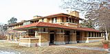
The Allen-Lambe House (2013)
-
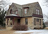
The C. M. Jackman House (2013)
-
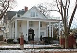
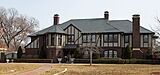
Chester Long House (2013)
-
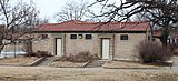
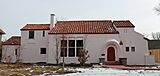
The College Hill Park Bathhouse (2013)
-
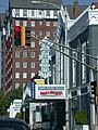
The Crown Uptown Theatre with the Hillcrest Apartments in the background (2003)
-
Frank Blaser House (2013)
-
Hillside Cottage (2013)
-
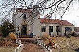
Powell House (2013)
-
R. D. W. Clapp House (2013)


.JPG)


