Collinwood, Tennessee facts for kids
Quick facts for kids
Collinwood, Tennessee
|
|||
|---|---|---|---|

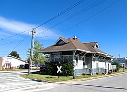
Collinwood Railroad Station
|
|||
|
|||

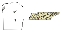
Location of Collinwood in Wayne County, Tennessee.
|
|||
| Country | United States | ||
| State | Tennessee | ||
| County | Wayne | ||
| Area | |||
| • Total | 2.78 sq mi (7.20 km2) | ||
| • Land | 2.78 sq mi (7.20 km2) | ||
| • Water | 0.00 sq mi (0.00 km2) | ||
| Elevation | 1,060 ft (323 m) | ||
| Population
(2020)
|
|||
| • Total | 898 | ||
| • Density | 322.91/sq mi (124.68/km2) | ||
| Time zone | UTC-6 (Central (CST)) | ||
| • Summer (DST) | UTC-5 (CDT) | ||
| ZIP code |
38450
|
||
| Area code(s) | 931 | ||
| FIPS code | 47-16480 | ||
| GNIS feature ID | 1269482 | ||
Collinwood is a small city located in Wayne County, Tennessee, in the United States. In 2020, about 898 people lived there. It's a friendly place with a rich history tied to railroads and local industries.
Contents
History of Collinwood
Collinwood started in 1913. It was a stop on the Tennessee Western Railroad. This train line was built to help the iron industry in the area. The city got its name from W.W. Collins. He was the president of the Collinwood Land Company. This company planned out the city.
The railroad was supposed to go further north. But it only went as far as Collinwood. So, Collinwood became the end of the line for this railroad. In June 1913, the Collinwood Land Company sold lots for the new city. By the next year, about 300 people lived there.
Most people worked for the railroad. Others worked in the local lumber industry. During World War I, Collinwood grew a lot. Its population went up to over 2,000 people. After the war, plants were built to make wood alcohol and iron. But when people didn't need these products as much, the city's economy slowed down. The train tracks were removed in the late 1930s.
The Collinwood Railroad Station was built in 1916. It is still standing in the city center. This station is a historic building. It shows what train stations looked like back then. Today, the old station is used as a library and a museum.
Geography of Collinwood
Collinwood is located at 35°10′13″N 87°44′34″W / 35.17028°N 87.74278°W. The city sits on a flat area. This area is surrounded by small hills. Streams in the eastern part of the city flow into Shoal Creek. Streams in the western part flow into Indian Creek. Both of these creeks eventually join the Tennessee River.
Collinwood is mainly along State Route 13. It is about halfway between Waynesboro to the north and the Tennessee-Alabama state line to the south. Another road, State Route 203, meets State Route 13 in Collinwood. This road connects the city to Savannah in the west. The Natchez Trace Parkway also goes through Collinwood.
The city covers an area of about 2.8 square miles (7.2 square kilometers). All of this area is land.
Population Information
| Historical population | |||
|---|---|---|---|
| Census | Pop. | %± | |
| 1950 | 589 | — | |
| 1960 | 596 | 1.2% | |
| 1970 | 922 | 54.7% | |
| 1980 | 1,064 | 15.4% | |
| 1990 | 1,014 | −4.7% | |
| 2000 | 1,024 | 1.0% | |
| 2010 | 982 | −4.1% | |
| 2020 | 898 | −8.6% | |
| Sources: | |||
People in Collinwood (2020)
| Group | Number of People | Percentage |
|---|---|---|
| White (not Hispanic) | 835 | 92.98% |
| Other/Mixed | 36 | 4.01% |
| Hispanic or Latino | 27 | 3.01% |
In 2020, there were 898 people living in Collinwood. There were 426 households and 298 families.
Fun Places and Businesses
- Ralph M. Hughes Memorial Park
- Collinwood City Park—Also known as Dixie Youth Park (You can go swimming, play tennis, and baseball here!)
- Wayne County Welcome Center
- Collinwood Depot Library/Museum (The old train station!)
- The Natchez Trace Parkway (A historic road for scenic drives)
- Hasti-Mart
- Roadhouse Express
- Dollar General
- Piggly Wiggly
- The Dragonfly Emporium
- Andy’s Barbershop
Churches in Collinwood
Here are some of the churches you can find in Collinwood:
- Cornerstone Church of Collinwood
- Collinwood Church of God
- Collinwood Church of Christ
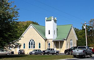
- Collinwood United Methodist Church
- Collinwood Free Will Baptist Church
Schools in Collinwood
- Collinwood High
- Collinwood Middle
- Collinwood Elementary
- Bevis Education Center
Local Manufacturing
- Hassell and Hughes
- Dixie Handle Company
Roads and Parkways
- Natchez Trace Parkway
 Tennessee State Route 13
 Tennessee State Route 203
Radio Station
- FM 94.9 WMSR-FM
See also
 In Spanish: Collinwood (Tennessee) para niños
 | Dorothy Vaughan |
 | Charles Henry Turner |
 | Hildrus Poindexter |
 | Henry Cecil McBay |


