Waynesboro, Tennessee facts for kids
Quick facts for kids
Waynesboro, Tennessee
|
|||
|---|---|---|---|
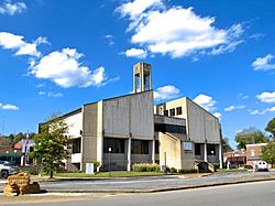
Wayne County Courthouse
|
|||
|
|||
| Motto(s):
Progressing toward our future, through an understanding of our past
|
|||
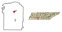
Location of Waynesboro in Wayne County, Tennessee.
|
|||
| Country | United States | ||
| State | Tennessee | ||
| County | Wayne | ||
| Established | 1821 | ||
| Incorporated | 1850 | ||
| Named for | General Anthony Wayne | ||
| Area | |||
| • Total | 4.28 sq mi (11.10 km2) | ||
| • Land | 4.28 sq mi (11.10 km2) | ||
| • Water | 0.00 sq mi (0.00 km2) | ||
| Elevation | 748 ft (228 m) | ||
| Population
(2020)
|
|||
| • Total | 2,317 | ||
| • Density | 540.85/sq mi (208.81/km2) | ||
| Time zone | UTC-6 (Central (CST)) | ||
| • Summer (DST) | UTC-5 (CDT) | ||
| ZIP code |
38485
|
||
| Area code(s) | 931 | ||
| FIPS code | 47-78600 | ||
| GNIS feature ID | 1326575 | ||
Waynesboro is a city in the state of Tennessee, United States. It is the main city and government center for Wayne County. In 2020, about 2,317 people lived there. The city's motto is "Progressing toward our future, through an understanding of our past."
Contents
History of Waynesboro
Waynesboro was started in 1821. It became the main town for the new Wayne County. The city began with a 40-acre area. This area included the courthouse and the jail.
A school called Ashland Academy opened in 1843. Waynesboro officially became a city in 1850.
Geography and Location
Waynesboro is located where two main roads meet: State Route 13 and U.S. Route 64. It is about 105 miles (169 km) south of Nashville. The city is also about 135 miles (217 km) east of Memphis.
Another road, State Route 99, connects Waynesboro to Hohenwald. The famous Natchez Trace Parkway is also just a few miles east of the city.
Waynesboro sits along the Green River. This river flows through a narrow valley. Hurricane Creek also joins the Green River just north of the city. A large forest area nearby is part of the Eagle Creek Wildlife Management Area. The city covers about 2.5 square miles (6.5 km2) of land.
Waynesboro Climate
| Climate data for Waynesboro, Tennessee (1991–2020 normals, extremes 1893–present) | |||||||||||||
|---|---|---|---|---|---|---|---|---|---|---|---|---|---|
| Month | Jan | Feb | Mar | Apr | May | Jun | Jul | Aug | Sep | Oct | Nov | Dec | Year |
| Record high °F (°C) | 79 (26) |
82 (28) |
91 (33) |
92 (33) |
96 (36) |
106 (41) |
108 (42) |
106 (41) |
107 (42) |
96 (36) |
86 (30) |
76 (24) |
108 (42) |
| Mean daily maximum °F (°C) | 48.9 (9.4) |
53.2 (11.8) |
62.0 (16.7) |
71.9 (22.2) |
78.6 (25.9) |
85.3 (29.6) |
88.4 (31.3) |
88.2 (31.2) |
83.1 (28.4) |
73.1 (22.8) |
60.9 (16.1) |
51.7 (10.9) |
70.4 (21.3) |
| Daily mean °F (°C) | 37.8 (3.2) |
41.2 (5.1) |
48.8 (9.3) |
57.7 (14.3) |
65.9 (18.8) |
73.7 (23.2) |
77.2 (25.1) |
76.2 (24.6) |
70.0 (21.1) |
59.0 (15.0) |
47.7 (8.7) |
40.5 (4.7) |
58.0 (14.4) |
| Mean daily minimum °F (°C) | 26.7 (−2.9) |
29.3 (−1.5) |
35.7 (2.1) |
43.4 (6.3) |
53.1 (11.7) |
62.1 (16.7) |
65.9 (18.8) |
64.1 (17.8) |
56.8 (13.8) |
44.9 (7.2) |
34.4 (1.3) |
29.4 (−1.4) |
45.5 (7.5) |
| Record low °F (°C) | −21 (−29) |
−20 (−29) |
2 (−17) |
19 (−7) |
27 (−3) |
34 (1) |
41 (5) |
41 (5) |
29 (−2) |
16 (−9) |
−5 (−21) |
−9 (−23) |
−21 (−29) |
| Average precipitation inches (mm) | 4.99 (127) |
5.61 (142) |
5.56 (141) |
5.59 (142) |
5.83 (148) |
5.27 (134) |
5.36 (136) |
4.43 (113) |
4.38 (111) |
4.40 (112) |
4.19 (106) |
6.18 (157) |
61.79 (1,569) |
| Average snowfall inches (cm) | 0.4 (1.0) |
0.4 (1.0) |
0.5 (1.3) |
0.0 (0.0) |
0.0 (0.0) |
0.0 (0.0) |
0.0 (0.0) |
0.0 (0.0) |
0.0 (0.0) |
0.0 (0.0) |
0.0 (0.0) |
0.0 (0.0) |
1.3 (3.3) |
| Average precipitation days (≥ 0.01 in) | 11.1 | 10.4 | 11.8 | 10.2 | 10.6 | 10.5 | 10.0 | 9.1 | 7.9 | 7.9 | 9.2 | 11.4 | 120.1 |
| Average snowy days (≥ 0.1 in) | 0.5 | 0.7 | 0.2 | 0.0 | 0.0 | 0.0 | 0.0 | 0.0 | 0.0 | 0.0 | 0.0 | 0.2 | 1.6 |
| Source: NOAA | |||||||||||||
Population and People
| Historical population | |||
|---|---|---|---|
| Census | Pop. | %± | |
| 1880 | 236 | — | |
| 1890 | 239 | 1.3% | |
| 1910 | 357 | — | |
| 1940 | 768 | — | |
| 1950 | 1,147 | 49.3% | |
| 1960 | 1,343 | 17.1% | |
| 1970 | 1,983 | 47.7% | |
| 1980 | 2,109 | 6.4% | |
| 1990 | 1,824 | −13.5% | |
| 2000 | 2,228 | 22.1% | |
| 2010 | 2,449 | 9.9% | |
| 2020 | 2,317 | −5.4% | |
| Sources: | |||
2020 Census Information
In 2020, the census counted 2,317 people living in Waynesboro. There were 937 households and 655 families. Most people identified as White (91.8%).
| Race | Number | Percentage |
|---|---|---|
| White (non-Hispanic) | 2,127 | 91.8% |
| Black or African American (non-Hispanic) | 54 | 2.33% |
| Native American | 3 | 0.13% |
| Asian | 14 | 0.6% |
| Other/Mixed | 70 | 3.02% |
| Hispanic or Latino | 49 | 2.11% |
Schools in Waynesboro
Waynesboro has several schools for students of all ages:
- Waynesboro Elementary School
- Waynesboro Middle School
- Wayne County High School
- Wayne County Technology Center
- Hollis Academy
Local Media
Waynesboro has a few radio stations:
- WWON Big Oldies 930
- W210BE 89.9 American Family Radio
- WWON-FM 100.7
Transportation and Roads
Major highways that pass through or near Waynesboro include:

 US 64 / SR 15
 SR 13
SR 13 SR 99
SR 99
Famous People from Waynesboro
Some notable people who have connections to Waynesboro include:
- Clay Allison – a famous gun fighter from the Old West
- Mark Collie – a country music singer
- Greg Seitz – the director of athletics at Jacksonville State University
See also
 In Spanish: Waynesboro (Tennessee) para niños
 | Anna J. Cooper |
 | Mary McLeod Bethune |
 | Lillie Mae Bradford |


