Colyton, New South Wales facts for kids
Quick facts for kids ColytonSydney, New South Wales |
|||||||||||||||
|---|---|---|---|---|---|---|---|---|---|---|---|---|---|---|---|

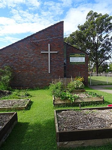
Presbyterian Community Church, Marsden Road, Colyton
|
|||||||||||||||
| Population | 7,993 (2011 census) | ||||||||||||||
| Established | 1846 | ||||||||||||||
| Postcode(s) | 2760 | ||||||||||||||
| Elevation | 57 m (187 ft) | ||||||||||||||
| Location | 43 km (27 mi) W of Sydney | ||||||||||||||
| LGA(s) | Penrith City Council | ||||||||||||||
| State electorate(s) | Londonderry | ||||||||||||||
| Federal Division(s) | Lindsay | ||||||||||||||
|
|||||||||||||||
Colyton is a suburb in Sydney, New South Wales, Australia. It's about 43 kilometres west of the centre of Sydney. Colyton is part of the City of Penrith area. It's also part of the bigger Greater Western Sydney region.
Colyton is one of the easternmost suburbs of the City of Penrith. Its borders are Ropes Creek, the Great Western Highway, Marsden Road, and the M4 Western Motorway. Colyton is an older suburb with many homes on large blocks of land. It is mostly a place where people live. You can find big sports fields, schools, a shopping centre, and the Life Education Centre here. There are also some industrial businesses along Roper Road.
Contents
History of Colyton
Colyton got its name from a town in Devon, England. This was the hometown of the wife of William Cox Junior. William Cox Senior was famous for building the first road across the Blue Mountains.
Early Land Grants
William Cox Junior was given 800 acres (about 3.2 square kilometres) of land here in 1819. This land was on the south side of the Western Highway. At first, the land was used for grazing animals and growing wheat.
The Village of Colyton
In 1842, William Cox's land was put up for sale. It was advertised as a chance to create the 'Village of Colyton'. The land was described as having good grass and timber for building. It also had plenty of water from nearby Ropes Creek.
Historically, the name Colyton usually meant the area east of Ropes Creek. The place we now call Colyton was once part of St Marys. The Colyton Post Office opened in 1892 but closed in 1962.
People in Colyton
The 2016 census found that 8,439 people lived in Colyton.
- About 5.1% of the people were Aboriginal and Torres Strait Islander.
- Most people (66.9%) were born in Australia.
- Other common birthplaces included New Zealand, the Philippines, England, Fiji, and India.
- Most people (68.9%) spoke only English at home.
- Other languages spoken included Arabic, Hindi, Tagalog, Samoan, and Greek.
- The most common religions were Catholic, No Religion, and Anglican.
- Many people worked in office jobs, as machinery operators, or in trades.
Getting Around Colyton
Colyton is easy to reach by car. It is close to the Great Western Highway and the M4 Motorway. Bus services are also available. These buses can take you to St Marys railway station, Westfield Mount Druitt, and Mount Druitt railway station.
Schools in Colyton
There are two schools located within the suburb of Colyton:
- Bennett Road Public School
- Colyton High School
Bennett Road Public School
Bennett Road Public School started in 1961. It first had 230 students. The school opened its library in 1984. A new hall and canteen were added in 1986.
Colyton High School
Colyton High School is a large high school serving the area.
Note: Colyton Public School is not actually in Colyton. It is located across the Great Western Highway in Old Mt Druitt. This school was established in the late 1800s. Its new school hall opened in November 2009.
Churches in Colyton
- Colyton Baptist Church holds services at Bennett Road Public School.
- The Christian Reformed Church is on Marsden Road.
- The Presbyterian Community Church is also on Marsden Road.
 | Delilah Pierce |
 | Gordon Parks |
 | Augusta Savage |
 | Charles Ethan Porter |

