St Clair, New South Wales facts for kids
Quick facts for kids St ClairSydney, New South Wales |
|||||||||||||||
|---|---|---|---|---|---|---|---|---|---|---|---|---|---|---|---|

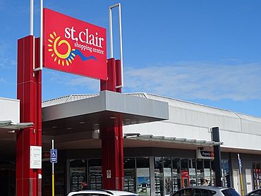
St Clair Shopping Centre c. 2015
|
|||||||||||||||
| Population | 19,837 (2011 census) | ||||||||||||||
| Established | 1981 | ||||||||||||||
| Postcode(s) | 2759 | ||||||||||||||
| Elevation | 50 m (164 ft) | ||||||||||||||
| Location | 44 km (27 mi) west of Sydney CBD | ||||||||||||||
| LGA(s) | Penrith City Council | ||||||||||||||
| State electorate(s) | Badgerys Creek | ||||||||||||||
| Federal Division(s) | McMahon | ||||||||||||||
|
|||||||||||||||
St Clair is a suburb located in Sydney, New South Wales, Australia. It's about 44 kilometres west of the main city area. St Clair is part of the City of Penrith and is known for its views of the beautiful Blue Mountains. It's a growing community with lots of families.
Contents
How St Clair Got Its Name
St Clair got its name from a new housing area that started in 1970. The local Post Office opened its doors on March 17, 1981.
First People of the Land
Long ago, the Dharug people were the traditional owners of this land. Sadly, by 1816, many Dharug people had passed away due to conflicts and illnesses brought by European settlers. Over time, their traditional way of life changed. They became more reliant on the settlers for food and clothing. Even though they had a camp near the Mamre estate, Reverend Samuel Marsden encouraged them to work for their needs.
European Settlers Arrive
This area was once called South Creek. Later, people unofficially called it South St Mary's. The southern part was known as Erskine Park. The land where St Clair now stands was once part of Chatsworth Nursery. This nursery was a branch of Darling Nursery, which started in 1827.
The owner, Thomas Shepherd, created a system to water his plants using water from Eastern Creek. A large part of the area was covered with beautiful camellias. The nursery later moved to Colyton and closed down by the end of the 1800s. The area stayed mostly rural until new houses were built in the 1970s.
Why the Name St Clair?
The name "St Clair" doesn't have old ties to the area. It was chosen for a housing project started in 1970 by a company called Latex Finance. This company later went bankrupt in 1976. The Land Commission of New South Wales then bought the land. They made the area bigger to create a large suburb.
In late 1981, the Geographical Names Board of New South Wales decided to split the area. They created two separate suburbs: St Clair and Erskine Park. Many people wanted the whole area to be called Erskine Park. Since 1981, St Clair's population has grown a lot. It is now a well-known suburb with modern facilities. It also has easy access to the M4 Motorway and a shopping centre.
Where is St Clair Located?
St Clair is surrounded by important roads. Erskine Park Road is to the east, the M4 Motorway is to the north, and Mamre Road is along its western side. The suburbs to the south and east of St Clair are part of Erskine Park.
St Clair has many parks and open spaces for fun activities. It's known for being a very family-friendly place. Next to St Clair is Erskine Park, which was once called "Fox Dale." Erskine Park is smaller than St Clair in terms of houses and people. However, a huge new industrial area is being built to the south. This area will bring new job opportunities.
Schools in St Clair
St Clair has one public high school called St Clair High School. It is located on Endeavour Avenue. Some students from St Clair also go to the nearby Erskine Park High School.
Private high schools close to St Clair include Emmaus Catholic College and Mamre Anglican School. For younger students, primary schools in St Clair are St Clair Public School, Banks Public School, Blackwell Public School, Clairgate Public School, and Holy Spirit Catholic School.
St Clair High School's New Look
On June 29, 2014, a fire happened at St Clair High School. Firefighters put out the fire by 5:45 AM. About 80% of a two-story building was damaged. Luckily, no one was hurt. After the fire, the Department of Education spent $20 million to rebuild the school. The new school opened in October 2018. It now has 16 new classrooms, a research area, a lecture hall, three new kitchens, and a cafe. There are also many outdoor learning areas and a large terraced space for students to enjoy.
Shopping and Fun
In 2008, the St Clair shopping centre got a big makeover. It now has new specialty stores, a food court, and outdoor seating. You can find medical services like X-ray and optometrists there. There are also food places, newsagents, fashion and jewellery shops, and electronics stores. The local library and a petrol station are also part of the centre.
Two local schools are next to the shopping centre. There are also soccer fields to the north, which include a new skate bowl. St Clair also has three BWS bottle shops. The Blue Cattle Dog Hotel is the only pub in St Clair or Erskine Park. It's located at the corner of Mamre Road and Banks Drive.
Leisure Centre
St Clair has an indoor leisure centre. It is located behind the St Clair Shopping Centre. The local government, Penrith City Council, manages this centre. It's a great place for sports and activities.
Community Support
Community Junction Inc. helps residents in St Clair, Erskine Park, Colyton, St Marys, and Werrington. This group manages several community halls for Penrith Council. They also run many programs for people living in these areas.
Churches
Holy Spirit Parish, St Clair.
 | Isaac Myers |
 | D. Hamilton Jackson |
 | A. Philip Randolph |


