
Concepción Chiquirichapa facts for kids
Quick facts for kids
Concepción Chiquirichapa
Conspyon
|
|
|---|---|
|
Municipality and town
|
|
| Nickname(s):
Conce
|
|

Concepción Chiquirichapa
Location in Guatemala
|
|
| Country | |
| Department | |
| Area | |
| • Municipality and town | 10.0 sq mi (25.9 km2) |
| • Land | 10.0 sq mi (25.9 km2) |
| Elevation | 8,415 ft (2,565 m) |
| Population
(2018 census)
|
|
| • Municipality and town | 17,342 |
| • Density | 1,734/sq mi (669.6/km2) |
| • Urban | 9,879 |
| Time zone | UTC+6 (Central Time) |
| Climate | Cwb |
Concepción Chiquirichapa is a town and municipality in Guatemala. It is located in the Quetzaltenango area, in the Western Highlands. The town is about 14 kilometers west of Quetzaltenango city. It is also 214 kilometers west of Guatemala City, the country's capital.
In 2018, Concepción Chiquirichapa had a population of 17,342 people. Most of the people, about 98%, are Maya-Mam. They speak a special kind of the Mam language.
Contents
History of Concepción Chiquirichapa
Early Days and Religious Influence

After the Spanish took over Guatemala in the 1520s, a religious group called the Mercedarians became important. They were given control over several towns, including Concepción Chiquirichapa.
The Mercedarians managed these towns for many years. However, in 1754, the Spanish kings made changes. They decided that religious orders like the Mercedarians had to give up control of their towns. So, Concepción Chiquirichapa was then managed by other church leaders.
The Legend of Chiquirichapa's Beginning

There's an old story about how Concepción Chiquirichapa began. It has been told by people for many generations. Long ago, the first people lived on a hill near another hill called "Tuicacaix." They built homes and even a wooden church for their religious activities. They called their town "Twisak Bajlak," which means "Place of White Shilote" in the Mam language. Shilote is a word for white corn.
One day, strange things started happening. Children began to disappear from the community. The mothers were worried because giant birds called "Tiw" were taking the little ones. These birds were taking the children to their nests high in the mountains.
The elders tried to protect the babies by covering their heads with baskets. But if a child was not covered, the giant birds would still take them. The villagers found it hard to fight the birds because their nests were too high. No one had ever dared to climb that mountain before.
Some brave people did climb up. They reported that the nests were like tunnels, about 2 meters wide and very deep. The town's leader, called a cacique, realized they needed a new, safer place to live. He sent men to search for a new home, but they came back without finding anything suitable.
Then, the cacique used his special stick, which had magical powers. He placed it on a mountain called "To-xucuwe" to see if it was a good place. But the mountain moved when he touched it, so he knew it wasn't safe.
After two failed attempts, the cacique and some friends went to "Popbil" hill. He planted his stick there again. This time, the mountain did not move! Everyone was very happy. They had found a new place by a lake, where they had once buried their dead. The search party returned with the good news. When the town moved, they left behind only the remains of the old church. Today, it is called "Tui Glesbén" in Mam, meaning "Place Where There was the Church."
The new place is where Concepción Chiquirichapa is located today. But even here, the giant birds still threatened the children. One day, the strongest men decided to climb the mountain and fill the birds' nests, finally getting rid of them. They succeeded, and the bird problem was solved.
However, a new problem appeared. Children would go into the nearby lake and never come back. The cacique used his power again. He made long sticks or tubes and used a piece of cotton. He prayed to the gods to make the lake water disappear through the tubes. As soon as he finished his prayer, the cotton soaked up the water. Then, the cacique pointed the tubes towards the East, and the water flowed away to create what is now Lake Atitlan.
Days later, the water was gone, leaving a huge valley. The land dried up, and both problems were solved. Children could now play safely without fear of birds or the lake.
All the land around belonged to the people of the original village. As the population grew, the leader told some people to move and take care of the forests to the North and South. Over time, these new settlements grew into new communities. These included San Juan Ostuncalco, Cajolá, San Miguel Sigüilá, San Martín Sacatepéquez, Varsovia, and Monrovia. Many of these towns later became their own municipalities in the Quetzaltenango Department. Concepción Chiquirichapa still says it was the first home for all of them.
What's in a Name?
The name "Chiquirichapa" comes from an old word meaning "The stream of cicadas or locusts." "Concepción" is a Catholic name given to honor the Virgin Mary. In 1860, the municipality was officially named "Concepcion Chiquirichapa."
People and Languages
The 17,342 people living in Concepción Chiquirichapa are mostly indigenous Mam. There are also some non-indigenous people, who are often called white. The main language spoken here is a type of Mam.
Beliefs and Faith
The people of Concepción Chiquirichapa have strong spiritual beliefs. They believe in a higher power that guides their community. There are both Evangelical (Protestant) churches and a Catholic Church in the town. People go to these churches daily to pray, give thanks, and honor their Creator. The Catholic Church building has a colonial style.
Fun Traditions and Customs
Concepción Chiquirichapa has many interesting customs and traditions.
Main Festival
The town's main festival is usually held from December 5th to 9th. The most important day is December 7th. On this day, the church celebrates in honor of the Conception of the Virgin Mary.
On December 7th, a procession carries the Virgin Mary through the main streets. People believe this brings great blessings to the town. When the procession returns to the church, there is a fireworks display in the churchyard every year.
On December 8th and 9th, musical groups perform in the churchyard. People celebrate the holiday with music and joy, following the traditions of the indigenous Mam people. Another important holiday is on July 22nd, which honors "Our Lady of Magdalene."
Market Day
The market days in Concepción Chiquirichapa are Sunday and Thursday. On these days, people gather in the main square to buy and sell goods. It's also a time for people to share their joys and sorrows.
Traditional Clothing
The women of Concepción Chiquirichapa wear beautiful traditional clothes. Their outfit includes a red Huipil (a type of blouse), a black skirt, and a woven belt. The women often make these clothes themselves. The red color of the huipil represents the blood shed by their ancestors. The dark or black skirt represents the evening. The belt shows the strength and purity of women.
Delicious Food and Drinks
The town has many typical foods. Some popular dishes include:
- Pepián (a rich stew)
- Jocón (a green chicken stew)
- Beef tripe soup
- Chicken broth
- Caldo de Pata (hoof broth)
- Levanta Carne (a meat dish)
- Preserved beef
- Chicken and egg wrapped with vegetables like potato, huisquil (chayote), green beans, and carrots.
- Of course, they also eat tortillas with their meals.
For drinks, they enjoy Such and Atol de masa (a warm corn drink).
Weather in Concepción Chiquirichapa
Concepción Chiquirichapa has a subtropical highland climate. This means it has mild temperatures all year round, with a rainy season and a drier season.
| Climate data for Concepción Chiquirichapa | |||||||||||||
|---|---|---|---|---|---|---|---|---|---|---|---|---|---|
| Month | Jan | Feb | Mar | Apr | May | Jun | Jul | Aug | Sep | Oct | Nov | Dec | Year |
| Mean daily maximum °C (°F) | 16.6 (61.9) |
17.3 (63.1) |
18.7 (65.7) |
19.7 (67.5) |
19.3 (66.7) |
18.3 (64.9) |
18.2 (64.8) |
18.7 (65.7) |
18.1 (64.6) |
17.4 (63.3) |
17.4 (63.3) |
16.9 (62.4) |
18.1 (64.5) |
| Daily mean °C (°F) | 9.2 (48.6) |
9.7 (49.5) |
11.0 (51.8) |
12.7 (54.9) |
13.8 (56.8) |
13.5 (56.3) |
13.3 (55.9) |
13.2 (55.8) |
13.3 (55.9) |
12.5 (54.5) |
11.1 (52.0) |
10.1 (50.2) |
11.9 (53.5) |
| Mean daily minimum °C (°F) | 1.8 (35.2) |
2.2 (36.0) |
3.4 (38.1) |
5.8 (42.4) |
8.3 (46.9) |
8.8 (47.8) |
8.5 (47.3) |
7.7 (45.9) |
8.6 (47.5) |
7.7 (45.9) |
4.9 (40.8) |
3.4 (38.1) |
5.9 (42.7) |
| Average precipitation mm (inches) | 4 (0.2) |
5 (0.2) |
14 (0.6) |
50 (2.0) |
186 (7.3) |
247 (9.7) |
183 (7.2) |
204 (8.0) |
284 (11.2) |
170 (6.7) |
24 (0.9) |
7 (0.3) |
1,378 (54.3) |
| Source: Climate-Data.org | |||||||||||||
Where is Concepción Chiquirichapa?
Concepción Chiquirichapa is in the middle of the Quetzaltenango Department. It is surrounded by other towns in this department. The area covers about 25.9 square kilometers, and the weather is generally cold. It is about 18 kilometers from Quetzaltenango city and 237 kilometers from Guatemala City.
 |
San Juan Ostuncalco and San Mateo | |
||
| San Juan Ostuncalco and San Martín Sacatepéquez | San Mateo and Quetzaltenango | |||
| San Martín Sacatepéquez and Quetzaltenango |
Images for kids
-

The Mercedarian coat of arms.
-
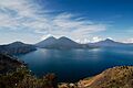
Lake Atitlan in Sololá Department, Guatemala. A legend says this lake was formed when a powerful leader moved a lake from Concepción Chiquirichapa to Sololá.
See also
 In Spanish: Concepción Chiquirichapa para niños
