Congelin, Western Australia facts for kids
Quick facts for kids CongelinWestern Australia |
|
|---|---|

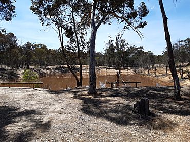
Congelin Railway Dam, part of the former Pinjarra to Narrogin railway at Congelin Railway Siding
|
|
| Established | 1913 |
| Postcode(s) | 6391 |
| Elevation | 278 m (912 ft) |
| Location | |
| LGA(s) | Shire of Williams |
| State electorate(s) | Roe |
| Federal Division(s) | O'Connor |
Congelin is a small area in the Wheatbelt region of Western Australia. It is located north of the town of Williams. This area is part of the Shire of Williams, which is like its local government district.
Contents
What is Congelin?
Congelin is not a big town today. It is mostly a quiet farming area. It sits near the edge of the Darling Scarp, which is a line of hills.
History of Congelin
How Congelin Got Its Name
In 1911, people living nearby wanted to create a town in this area. They called it Congelin. The name comes from an Aboriginal word. It is believed to be named after a nearby waterhole. However, the exact meaning of the name is not known today.
When Congelin Became Official
Congelin was officially recognized as a town in 1913. This is called being "gazetted." Even though it was made an official town, it never really grew very much. It stayed a quiet place with not many people living there.
Congelin Today
Today, Congelin is still a farming area. The local government, the Shire of Williams, has plans to improve some of the roads in the area. This includes parts of the road that connects Congelin to Narrogin.
 | Bessie Coleman |
 | Spann Watson |
 | Jill E. Brown |
 | Sherman W. White |


