Congerville, Illinois facts for kids
Quick facts for kids
Congerville
|
|
|---|---|

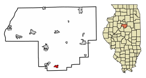
Location of Congerville in Woodford County, Illinois.
|
|

Location of Illinois in the United States
|
|
| Country | United States |
| State | Illinois |
| County | Woodford |
| Area | |
| • Total | 0.97 sq mi (2.50 km2) |
| • Land | 0.96 sq mi (2.49 km2) |
| • Water | 0.00 sq mi (0.01 km2) |
| Elevation | 745 ft (227 m) |
| Population
(2020)
|
|
| • Total | 497 |
| • Density | 516.10/sq mi (199.35/km2) |
| Time zone | UTC-6 (CST) |
| • Summer (DST) | UTC-5 (CDT) |
| ZIP Code(s) |
61729
|
| Area code(s) | 309 |
| FIPS code | 17-16119 |
| Wikimedia Commons | Congerville, Illinois |
Congerville is a small village located in Woodford County, Illinois, in the United States. It's a part of the larger Peoria area. In 2020, about 497 people lived there, making it a close-knit community.
Contents
The Story of Congerville's Name
Congerville has an interesting history, especially when it comes to its name! The area where the village now stands was first surveyed for a person named Joseph Schrock on January 2, 1888. Because of this, the village was first known as Schrock.
However, the name didn't stick for long. On February 27, 1888, it was changed to Conger. This new name honored an early settler in the area, Ben Conger. Just a few months later, on July 31, 1888, the name was changed one last time to Congerville, which is what it's called today.
Where is Congerville?
Congerville is located in Illinois at these coordinates: 40°36′51″N 89°12′24″W / 40.614130°N 89.206576°W.
This village once held a special record for being the coldest place in Illinois! On January 5, 1999, the temperature dropped to an amazing -36 degrees Fahrenheit (that's -38 degrees Celsius!). This was the coldest temperature ever officially recorded in the state at that time.
Before Congerville, the record was held by Mount Carroll, which had a temperature of -35 degrees Fahrenheit in 1930. However, Mount Carroll took the record back on January 31, 2019, when it got even colder there, reaching -38 degrees Fahrenheit!
Congerville covers a total area of about 1.12 square miles (2.9 square kilometers). Most of this area is land, with only a tiny bit being water.
Who Lives in Congerville?
| Historical population | |||
|---|---|---|---|
| Census | Pop. | %± | |
| 1970 | 266 | — | |
| 1980 | 373 | 40.2% | |
| 1990 | 397 | 6.4% | |
| 2000 | 466 | 17.4% | |
| 2010 | 474 | 1.7% | |
| 2020 | 497 | 4.9% | |
| U.S. Decennial Census | |||
The population of Congerville has slowly grown over the years. In 1970, there were 266 people living there. By 2020, the population had increased to 497 residents.
According to the 2000 census, there were 466 people living in the village. Most of the people living in Congerville were White. About 37.4% of the homes had children under 18 living there. The average household had about 2.86 people.
The people in Congerville are of different ages. About 28.5% of the population was under 18 years old. The median age was 30 years old, meaning half the people were younger than 30 and half were older.
Famous People from Congerville
Congerville has been home to some notable individuals:
- Simon E. Lantz: He was a farmer and a politician in Illinois. He lived in Congerville and was involved in state politics.
- Andy Studebaker: He is a professional football player. Andy played as an outside linebacker for several teams in the NFL, including the Philadelphia Eagles, Kansas City Chiefs, and Indianapolis Colts.
See also
 In Spanish: Congerville para niños
 | Chris Smalls |
 | Fred Hampton |
 | Ralph Abernathy |

